Difference between revisions of "2022-07-31 52 5"
From Geohashing
(Created page with "{{subst:Expedition}}") |
m (subst-ing) |
||
| (4 intermediate revisions by 3 users not shown) | |||
| Line 1: | Line 1: | ||
| − | + | [[Image:{{{image|2022-07-31 52 5 surroundings.jpeg}}}|thumb|left]] | |
| − | + | {{meetup graticule | |
| − | + | | lat=52 | |
| − | + | | lon=5 | |
| − | + | | date=2022-07-31 | |
| − | |||
| − | |||
| − | |||
| − | | lat= | ||
| − | | lon= | ||
| − | | date= | ||
}}<!-- edit as necessary --> | }}<!-- edit as necessary --> | ||
__NOTOC__ | __NOTOC__ | ||
== Location == | == Location == | ||
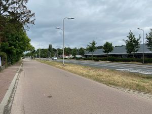
| − | + | Next to the Utrechtseweg in De Bilt. | |
== Participants == | == Participants == | ||
| − | + | [[User:Xnyhps|Xnyhps]] ([[User talk:Xnyhps|talk]]) | |
| − | |||
== Plans == | == Plans == | ||
| − | + | === xnyhps === | |
| + | I was planning to make a cycling trip anyway, so when the hash showed up as being on the grass between the road and the adjacent cycling path I decided to go for it. Planned a route from Zeist, via De Bilt to Utrecht which would take me past the hash point. | ||
== Expedition == | == Expedition == | ||
| − | + | Everything went as planned, although a bit more rainy than the forecast had shown. | |
| − | |||
| − | |||
| − | |||
== Photos == | == Photos == | ||
| − | |||
| − | |||
| − | |||
<gallery perrow="5"> | <gallery perrow="5"> | ||
| + | Image:2022-07-31 52 5 proof.png | Proof | ||
| + | Image:2022-07-31 52 5 hash.jpeg | The location of the hash | ||
| + | Image:2022-07-31 52 5 surroundings.jpeg | The surroundings of the hash point | ||
| + | Image:2022-07-31 52 5 pano.jpeg | Panorama around the hash point (with an interesting bus driving by) | ||
</gallery> | </gallery> | ||
| Line 40: | Line 32: | ||
<!-- Add any achievement ribbons you earned below, or remove this section --> | <!-- Add any achievement ribbons you earned below, or remove this section --> | ||
| − | |||
| − | |||
| − | |||
| − | |||
| − | |||
| − | |||
| − | |||
| − | |||
| − | |||
| − | |||
| − | |||
| − | |||
| − | |||
| − | |||
[[Category:Expeditions]] | [[Category:Expeditions]] | ||
| − | + | [[Category:Coordinates reached]] | |
[[Category:Expeditions with photos]] | [[Category:Expeditions with photos]] | ||
| − | + | {{location|NL|UT}} | |
| − | |||
| − | |||
| − | |||
| − | |||
| − | |||
| − | |||
| − | |||
| − | |||
| − | |||
| − | |||
| − | |||
| − | |||
| − | |||
| − | |||
| − | |||
| − | |||
| − | |||
| − | |||
| − | |||
| − | |||
| − | |||
| − | |||
| − | |||
Latest revision as of 20:50, 24 May 2024
| Sun 31 Jul 2022 in 52,5: 52.1009832, 5.1671697 geohashing.info google osm bing/os kml crox |
Location
Next to the Utrechtseweg in De Bilt.
Participants
Plans
xnyhps
I was planning to make a cycling trip anyway, so when the hash showed up as being on the grass between the road and the adjacent cycling path I decided to go for it. Planned a route from Zeist, via De Bilt to Utrecht which would take me past the hash point.
Expedition
Everything went as planned, although a bit more rainy than the forecast had shown.


