Difference between revisions of "2022-08-18 59 18"
([live picture]A location in the forest just north of Angarnsjöängens nature preserve. I took a car to the northern parking lot. From there I was only about 700m from the spot. I pretty much just tried to wing my way there and started on a trail that...) |
m (Location) |
||
| (2 intermediate revisions by 2 users not shown) | |||
| Line 15: | Line 15: | ||
== Location == | == Location == | ||
<!-- where you've surveyed the hash to be --> | <!-- where you've surveyed the hash to be --> | ||
| + | A location in the forest just north of Angarnsjöängens nature preserve. | ||
== Participants == | == Participants == | ||
<!-- who attended: If you link to your wiki user name in this section, your expedition will be picked up by the various statistics generated for geohashing. You may use three tildes ~ as a shortcut to automatically insert the user signature of the account you are editing with. | <!-- who attended: If you link to your wiki user name in this section, your expedition will be picked up by the various statistics generated for geohashing. You may use three tildes ~ as a shortcut to automatically insert the user signature of the account you are editing with. | ||
--> | --> | ||
| + | *[[User:deep-thot|deep-thot]] | ||
== Plans == | == Plans == | ||
| Line 25: | Line 27: | ||
== Expedition == | == Expedition == | ||
<!-- how it all turned out. your narrative goes here. --> | <!-- how it all turned out. your narrative goes here. --> | ||
| + | I took a car to the northern parking lot. From there I was only about 700m from the spot. I pretty much just tried to wing my way there and started on a trail that seemed to be heading in the right direction. However it soon ended in a really thick patch of deciduous trees, which I had to find my way around. It turned out to be not that big and I made my way to the spot by part bushwhacking, part following very loosely defined trails. The location itself was in a bit of lighter forest, right on top of what seemed like an old forestry trail. | ||
| + | |||
| + | Going back, I did the smart thing and used the local Strava heatmaps to find a much more convenient route back to the car. | ||
== Tracklog == | == Tracklog == | ||
| Line 35: | Line 40: | ||
<gallery perrow="5"> | <gallery perrow="5"> | ||
| − | Image:2022-08-18_59_18_deep-thot_1660831525810.jpg| | + | Image:2022-08-18_59_18_deep-thot_1660831525810.jpg|The location itself was in a bit of lighter forest, right on top of what seemed like an old forestry trail. |
| − | + | Image:2022-08-18_59_18_deep-thot_1660831636039.jpg|Proof of presence | |
| − | The location itself was in a bit of lighter forest, right on top of what seemed like an old forestry trail. | ||
| − | |||
| − | |||
</gallery> | </gallery> | ||
| Line 46: | Line 48: | ||
<!-- Add any achievement ribbons you earned below, or remove this section --> | <!-- Add any achievement ribbons you earned below, or remove this section --> | ||
| − | |||
| − | |||
| − | |||
| − | |||
| − | |||
| − | |||
| − | |||
| − | |||
| − | |||
| − | |||
| − | |||
| − | |||
| − | |||
| − | |||
[[Category:Expeditions]] | [[Category:Expeditions]] | ||
| − | |||
[[Category:Expeditions with photos]] | [[Category:Expeditions with photos]] | ||
| − | |||
| − | |||
| − | |||
| − | |||
| − | |||
[[Category:Coordinates reached]] | [[Category:Coordinates reached]] | ||
| − | + | {{location|SE|AB}} | |
| − | |||
| − | |||
| − | |||
| − | |||
| − | |||
| − | |||
| − | |||
| − | |||
| − | |||
| − | |||
| − | |||
| − | |||
| − | |||
| − | |||
| − | |||
| − | |||
| − | |||
Latest revision as of 16:44, 21 August 2022
| Thu 18 Aug 2022 in 59,18: 59.5641103, 18.1742680 geohashing.info google osm bing/os kml crox |
Location
A location in the forest just north of Angarnsjöängens nature preserve.
Participants
Plans
Expedition
I took a car to the northern parking lot. From there I was only about 700m from the spot. I pretty much just tried to wing my way there and started on a trail that seemed to be heading in the right direction. However it soon ended in a really thick patch of deciduous trees, which I had to find my way around. It turned out to be not that big and I made my way to the spot by part bushwhacking, part following very loosely defined trails. The location itself was in a bit of lighter forest, right on top of what seemed like an old forestry trail.
Going back, I did the smart thing and used the local Strava heatmaps to find a much more convenient route back to the car.
Tracklog
Photos
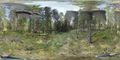
The location itself was in a bit of lighter forest, right on top of what seemed like an old forestry trail.
Proof of presence

