Difference between revisions of "2022-08-20 58 5"
From Geohashing
(→Location) |
(→Achievements) |
||
| (11 intermediate revisions by 3 users not shown) | |||
| Line 12: | Line 12: | ||
| date=2022-08-20 | | date=2022-08-20 | ||
}}<!-- edit as necessary --> | }}<!-- edit as necessary --> | ||
| − | |||
== Location == | == Location == | ||
<!-- where you've surveyed the hash to be --> | <!-- where you've surveyed the hash to be --> | ||
| − | Bore, Klepp, Norway | + | In a small forest in Bore, Klepp, Norway |
== Participants == | == Participants == | ||
<!-- who attended: If you link to your wiki user name in this section, your expedition will be picked up by the various statistics generated for geohashing. You may use three tildes ~ as a shortcut to automatically insert the user signature of the account you are editing with. | <!-- who attended: If you link to your wiki user name in this section, your expedition will be picked up by the various statistics generated for geohashing. You may use three tildes ~ as a shortcut to automatically insert the user signature of the account you are editing with. | ||
--> | --> | ||
| + | *[[User:Pica42|Pica42]] | ||
== Plans == | == Plans == | ||
| Line 26: | Line 26: | ||
== Expedition == | == Expedition == | ||
<!-- how it all turned out. your narrative goes here. --> | <!-- how it all turned out. your narrative goes here. --> | ||
| + | Today's trip was a nice trip in beautiful summer weather. In addition to the geohash, I also found 7 geocaches. | ||
== Tracklog == | == Tracklog == | ||
<!-- if your GPS device keeps a log, you may use Template:Tracklog, post a link here, or both --> | <!-- if your GPS device keeps a log, you may use Template:Tracklog, post a link here, or both --> | ||
| + | |||
| + | {{tracklog |Activity 9440219224.gpx}} | ||
== Photos == | == Photos == | ||
| Line 37: | Line 40: | ||
Image:2022-08-20_58_5_Pica42_1660984669597.jpg|Bore [https://openstreetmap.org/?mlat=58.79091530&mlon=5.56537870&zoom=16 @58.7909,5.5654] | Image:2022-08-20_58_5_Pica42_1660984669597.jpg|Bore [https://openstreetmap.org/?mlat=58.79091530&mlon=5.56537870&zoom=16 @58.7909,5.5654] | ||
| + | Image:20220820 01.jpg|thumb|I found cranberries on the way to the hash. | ||
| + | Image:20220820 02 NW.jpg|thumb|View from the hash to the northwest. | ||
| + | Image:20220820 03 SE.jpg|thumb|View from the hash to the southeast. | ||
| + | Image:20220820 04.jpg|thumb|I passed this figure on my way home. | ||
| + | Image:20220820 113930.jpg|thumb|View from Borestranda. | ||
</gallery> | </gallery> | ||
| Line 43: | Line 51: | ||
<!-- Add any achievement ribbons you earned below, or remove this section --> | <!-- Add any achievement ribbons you earned below, or remove this section --> | ||
| − | + | {{land geohash |name=[[User:Pica42|Pica42]] |date=2022-08-03 |latitude=58 |longitude=5 }} | |
| − | + | ||
| − | [[ | ||
| − | |||
| − | |||
| − | |||
| − | |||
| − | |||
| − | |||
| − | + | __NOTOC__ | |
[[Category:Expeditions]] | [[Category:Expeditions]] | ||
| − | |||
[[Category:Expeditions with photos]] | [[Category:Expeditions with photos]] | ||
| − | |||
| − | |||
| − | |||
| − | |||
| − | |||
[[Category:Coordinates reached]] | [[Category:Coordinates reached]] | ||
| − | + | {{location|NO|11}} | |
| − | |||
| − | |||
| − | |||
| − | |||
| − | |||
| − | |||
| − | |||
| − | |||
| − | |||
| − | |||
| − | |||
| − | |||
| − | |||
| − | |||
| − | |||
| − | |||
| − | |||
Latest revision as of 17:02, 20 November 2022
| Sat 20 Aug 2022 in 58,5: 58.7908258, 5.5654495 geohashing.info google osm bing/os kml crox |
Location
In a small forest in Bore, Klepp, Norway
Participants
Plans
Expedition
Today's trip was a nice trip in beautiful summer weather. In addition to the geohash, I also found 7 geocaches.
Tracklog
Photos

Bore @58.7909,5.5654
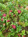
I found cranberries on the way to the hash.
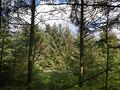
View from the hash to the northwest.
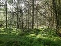
View from the hash to the southeast.
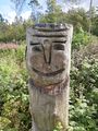
I passed this figure on my way home.
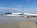
View from Borestranda.


Achievements
Pica42 earned the Land geohash achievement
|