Difference between revisions of "2022-08-28 -37 144"
Felix Dance (talk | contribs) ([live picture]Beers!) |
m (Location) |
||
| (5 intermediate revisions by 2 users not shown) | |||
| Line 1: | Line 1: | ||
| − | + | [[Image:{{{image|2022-08-28_-37_144_Felix Dance_1661691286373.jpg}}}|thumb|left]] | |
| − | + | {{meetup graticule | |
| − | |||
| − | |||
| − | |||
| − | |||
| − | |||
| − | |||
| lat=-37 | | lat=-37 | ||
| lon=144 | | lon=144 | ||
| date=2022-08-28 | | date=2022-08-28 | ||
| − | }} | + | }} |
| + | |||
== Location == | == Location == | ||
| − | + | On the nature strip of Kennedy St in Keilor at night. | |
== Participants == | == Participants == | ||
| − | + | *[[User:Felix Dance|Felix Dance]] | |
| − | + | *[[User:Mdixon4|Matt]] | |
| + | *[[User:Lachie|Lachie]] | ||
| + | *[[User:johnwrw|John]] | ||
| − | == | + | == Expedition - Felix Dance == |
| − | + | Matt had the absurd idea: instead of going to bed at 10pm on a work night, we'd get on our bikes, meet up, and do two consecutive geohashes overnight. | |
| − | + | The plan as executed was to meet at the Maribyrnong River in Moonee Ponds (I mistakenly tried to meet at Moonee Ponds Creek in the federal electorate of Maribyrnong, costing us valuable minutes), ride out along the river bike path to Keilor, grab the hash on the side of the road - beering it up to celebrate, of course - and then, as midnight approached, head along the M80 Ring Road bike path towards the [[2022-08-29 -37 144]] geohash. And that's pretty much how it went down. | |
| − | + | ||
| + | It was a beautiful night for riding, with unseasonably warm air, clear skies for which to show off Jupiter in most of its glory, and frequent plane overflights to heighten the atmosphere. Lachie did a masterful job of directing us and we met Part II of the hash in good time. | ||
== Tracklog == | == Tracklog == | ||
| − | + | {{Tracklog | 20220828_215723 2 Hashes.gpx}} | |
== Photos == | == Photos == | ||
| − | |||
| − | |||
| − | |||
<gallery perrow="5"> | <gallery perrow="5"> | ||
Image:2022-08-28_-37_144_Felix Dance_1661691286367.jpg|GPS proof | Image:2022-08-28_-37_144_Felix Dance_1661691286367.jpg|GPS proof | ||
| + | Image:2022-08-28_-37_144_Felix Dance_1661691286373.jpg|Beers! | ||
| + | Image:2022-08-28_-37_144_Felix Dance_1661693036763.jpg|At the hash! | ||
| − | |||
</gallery> | </gallery> | ||
== Achievements == | == Achievements == | ||
{{#vardefine:ribbonwidth|100%}} | {{#vardefine:ribbonwidth|100%}} | ||
| − | + | {{bicycle geohash | |
| − | + | | latitude = -37 | |
| − | + | | longitude = 144 | |
| − | + | | date = 2022-08-28 | |
| − | [[ | + | | name = [[User:Felix Dance|Felix Dance]], [[User:Mdixon4|Matt]], [[User:Lachie|Lachie]] and [[User:johnwrw|John]] |
| + | | distance = 42 kms | ||
| + | | bothways = true | ||
| + | | image = 2022-08-28_-37_144_Felix Dance_1661693036763.jpg | ||
| − | + | }} | |
| − | + | __NOTOC__ | |
| − | |||
| − | |||
| − | |||
| − | |||
| − | |||
| − | |||
[[Category:Expeditions]] | [[Category:Expeditions]] | ||
| − | |||
[[Category:Expeditions with photos]] | [[Category:Expeditions with photos]] | ||
| − | |||
| − | |||
| − | |||
| − | |||
| − | |||
[[Category:Coordinates reached]] | [[Category:Coordinates reached]] | ||
| − | + | {{location|AU|VIC|BR}} | |
| − | |||
| − | |||
| − | |||
| − | |||
| − | |||
| − | |||
| − | |||
| − | |||
| − | |||
| − | |||
| − | |||
| − | |||
| − | |||
| − | |||
| − | |||
| − | |||
| − | |||
Latest revision as of 18:42, 4 September 2022

| Sun 28 Aug 2022 in -37,144: -37.7196101, 144.8334665 geohashing.info google osm bing/os kml crox |
Location
On the nature strip of Kennedy St in Keilor at night.
Participants
Expedition - Felix Dance
Matt had the absurd idea: instead of going to bed at 10pm on a work night, we'd get on our bikes, meet up, and do two consecutive geohashes overnight.
The plan as executed was to meet at the Maribyrnong River in Moonee Ponds (I mistakenly tried to meet at Moonee Ponds Creek in the federal electorate of Maribyrnong, costing us valuable minutes), ride out along the river bike path to Keilor, grab the hash on the side of the road - beering it up to celebrate, of course - and then, as midnight approached, head along the M80 Ring Road bike path towards the 2022-08-29 -37 144 geohash. And that's pretty much how it went down.
It was a beautiful night for riding, with unseasonably warm air, clear skies for which to show off Jupiter in most of its glory, and frequent plane overflights to heighten the atmosphere. Lachie did a masterful job of directing us and we met Part II of the hash in good time.
Tracklog
Photos
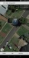
GPS proof
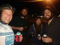
Beers!
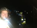
At the hash!


Achievements
Felix Dance, Matt, Lachie and John earned the Bicycle geohash achievement
|