Difference between revisions of "2022-09-09 52 -0"
PeterRoder (talk | contribs) m |
m (subst-ing) |
||
| (3 intermediate revisions by 2 users not shown) | |||
| Line 1: | Line 1: | ||
{{meetup graticule | {{meetup graticule | ||
| − | | lat= | + | | lat=52 |
| − | | lon= | + | | lon=-0 |
| − | | date= | + | | date=2022-09-09 |
}} | }} | ||
== Location == | == Location == | ||
| Line 8: | Line 8: | ||
== Participants == | == Participants == | ||
| − | [[PeterRoder]] | + | [[User:PeterRoder|PeterRoder]] |
== Expedition == | == Expedition == | ||
| − | + | After leaving home at about 10:00, the start of the route was my walk to school from over a decade ago, so was quite nostalgic. The rest of the route was also familiar, but I still made a slight navigational error, crossing the H5 too early. Fortunately, this had very little effect on the length of my journey, and I reached the general vicinity of the hash at about 10:50. [[Image:2022-09-09 52 -0 at the hash.jpg|thumb|upright|left|Found it]]The hash itself was just on the other side of a barbed wire fence, but I was well within the gps circle of uncertainty just by leaning over the fence, so I did not feel the need to climb it. | |
| + | |||
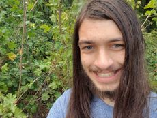
| + | [[Image:2022-09-09 52 -0 me.jpg|thumb|upright|right|Stupid grin]] | ||
| + | |||
| + | I then walked up a hill and took photos of a couple of sculptures in the park (red cross marks the approximate hash location). | ||
| + | |||
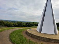
| + | [[Image:2022-09-09 52 -0 light pyramid.jpg|thumb|upright|left|The "Light Pyramid"]] | ||
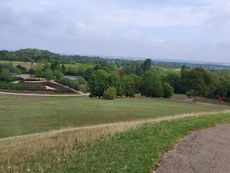
| + | [[Image:2022-09-09 52 -0 chain reaction.jpg|thumb|upright|right|"Chain Reaction"]] | ||
| + | |||
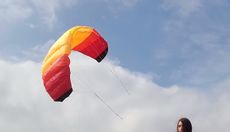
| + | I had also brought a kite with me, hoping to [[Fly a kite achievement|fly it]], but photographing this by myself was rather challenging. The only place I could be in the wind and in view of the hash was next to the light pyramid. I left my tablet leaning against the light pyramid videoing me, but as this was only a few meters away from the edge of the hill, I couldn't fit the kite a full length in frame. Instead, I flew it on a couple of meters of string to get the picture, then did some proper kite flying afterwards. | ||
| + | |||
| + | [[Image:2022-09-09 52 -0 kite.jpg|thumb|upright|left]] | ||
| + | |||
| + | I set off at about 11:10. The return journey was uneventful, and I took the correct route this time, bringing me home at 12:00. | ||
== Tracklog == | == Tracklog == | ||
| − | + | {{Tracklog|2022-09-09 52 -0.gpx}} | |
| − | |||
| − | |||
| − | |||
| − | |||
| − | |||
| − | |||
== Achievements == | == Achievements == | ||
{{#vardefine:ribbonwidth|100%}} | {{#vardefine:ribbonwidth|100%}} | ||
| − | |||
| − | + | {{Fly a kite achievement | |
| − | + | | latitude = 52 | |
| − | + | | longitude = -0 | |
| − | [[ | + | | date = 2022-09-09 |
| + | | name = [[User:PeterRoder|Peter]] | ||
| + | }} | ||
| − | |||
| − | |||
| + | __NOTOC__ | ||
[[Category:Expeditions]] | [[Category:Expeditions]] | ||
| − | + | ||
[[Category:Expeditions with photos]] | [[Category:Expeditions with photos]] | ||
| − | |||
| − | + | ||
| − | |||
[[Category:Coordinates reached]] | [[Category:Coordinates reached]] | ||
| + | {{location|GB|ENG|MIK}} | ||
Latest revision as of 20:51, 24 May 2024
| Fri 9 Sep 2022 in 52,-0: 52.0481390, -0.7423466 geohashing.info google osm bing/os kml crox |
Location
Campbell Park, Milton Keynes
Participants
Expedition
After leaving home at about 10:00, the start of the route was my walk to school from over a decade ago, so was quite nostalgic. The rest of the route was also familiar, but I still made a slight navigational error, crossing the H5 too early. Fortunately, this had very little effect on the length of my journey, and I reached the general vicinity of the hash at about 10:50.
The hash itself was just on the other side of a barbed wire fence, but I was well within the gps circle of uncertainty just by leaning over the fence, so I did not feel the need to climb it.
I then walked up a hill and took photos of a couple of sculptures in the park (red cross marks the approximate hash location).
I had also brought a kite with me, hoping to fly it, but photographing this by myself was rather challenging. The only place I could be in the wind and in view of the hash was next to the light pyramid. I left my tablet leaning against the light pyramid videoing me, but as this was only a few meters away from the edge of the hill, I couldn't fit the kite a full length in frame. Instead, I flew it on a couple of meters of string to get the picture, then did some proper kite flying afterwards.
I set off at about 11:10. The return journey was uneventful, and I took the correct route this time, bringing me home at 12:00.
Tracklog
Achievements
Peter earned the Fly a kite achievement
|


