Difference between revisions of "2022-11-09 53 9"
(preliminary report) |
m (subst-ing) |
||
| (2 intermediate revisions by one other user not shown) | |||
| Line 1: | Line 1: | ||
{{meetup graticule | {{meetup graticule | ||
| − | | lat= | + | | lat=53 |
| − | | lon= | + | | lon=9 |
| − | | date= | + | | date=2022-11-09 |
}} | }} | ||
| Line 12: | Line 12: | ||
==Expedition== | ==Expedition== | ||
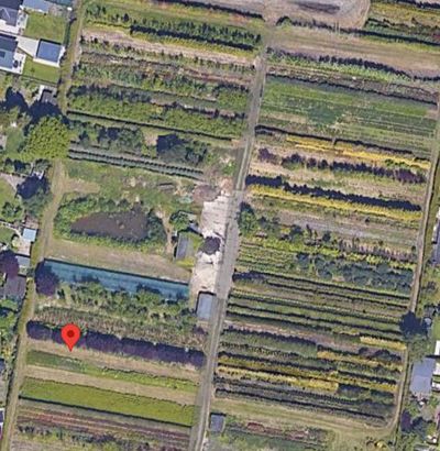
| − | + | Today's hash was not far from [[wikipedia:DESY|DESY]], where on Wednesdays this semester I attend a lecture on general relativity. So after I finished at uni I cycled and walked around the DESY campus for a bit (there's always something more to discover, I love exploring the place), then cycled 6.4 km through Lurup and Schenefeld to the hash. I was very curious about the place, because I could absolutely not tell what kind of environment it was in from the satellite imagery, which looks like this: | |
| + | |||
| + | [[File:2022-11-09 53 9 sat.jpg|400px]]. | ||
| + | |||
| + | But when I arrived, I got even more confused about the place. On Discord, I later described it as ''"rows and rows of different vegetation, some cultivated, some left to itself, some fallow; many hedgerows and rows of trees, and some neglected man-made structures in between. But I don't know what it's for, it seems like every 10 m strip was given to a different person to choose what to grow there. And there's residential area all around. I've never seen anything like it."'' | ||
| + | |||
| + | The hash lay on some grass in one of the many rows. I walked along all of them and became ever more puzzled: What was this place? Who owned it, and why wasn't it residential like everything around it? Who planted all these rows of different plants, and for what purpose? There were no fences, but some had metal supports, some roofings, some were empty, some were lakes, and all of them (except one actual private garden in the corner) looked forlorn. There were a house and shack, both overgrown. The door to the ground floor of the house opened (just barely), the entire room was full of (enter your guesses now) … warehouse transport trolleys. | ||
| + | |||
| + | After taking lots of pictures of the rows, I cycled to Halstenbek station, had to wait a while for the train to Eidelstedt and then rode home. | ||
| + | |||
| + | Definitely one of the most interesting and the most baffling place I've hashed. | ||
==Photos== | ==Photos== | ||
Latest revision as of 20:53, 24 May 2024
| Wed 9 Nov 2022 in 53,9: 53.6145241, 9.8351106 geohashing.info google osm bing/os kml crox |
Location
on [whatever the frak it was] in Halstenbek, Schleswig-Holstein
Participants
Expedition
Today's hash was not far from DESY, where on Wednesdays this semester I attend a lecture on general relativity. So after I finished at uni I cycled and walked around the DESY campus for a bit (there's always something more to discover, I love exploring the place), then cycled 6.4 km through Lurup and Schenefeld to the hash. I was very curious about the place, because I could absolutely not tell what kind of environment it was in from the satellite imagery, which looks like this:
But when I arrived, I got even more confused about the place. On Discord, I later described it as "rows and rows of different vegetation, some cultivated, some left to itself, some fallow; many hedgerows and rows of trees, and some neglected man-made structures in between. But I don't know what it's for, it seems like every 10 m strip was given to a different person to choose what to grow there. And there's residential area all around. I've never seen anything like it."
The hash lay on some grass in one of the many rows. I walked along all of them and became ever more puzzled: What was this place? Who owned it, and why wasn't it residential like everything around it? Who planted all these rows of different plants, and for what purpose? There were no fences, but some had metal supports, some roofings, some were empty, some were lakes, and all of them (except one actual private garden in the corner) looked forlorn. There were a house and shack, both overgrown. The door to the ground floor of the house opened (just barely), the entire room was full of (enter your guesses now) … warehouse transport trolleys.
After taking lots of pictures of the rows, I cycled to Halstenbek station, had to wait a while for the train to Eidelstedt and then rode home.
Definitely one of the most interesting and the most baffling place I've hashed.
Photos
will follow shortly (23+ pictures)
Achievements
Land geohash, Public transport geohash
