Difference between revisions of "2022-12-15 42 -71"
From Geohashing
([live picture]Requisite Silly Grin at hashpoint [https://openstreetmap.org/?mlat=42.36963100&mlon=-71.08053470&zoom=16 @42.3696,-71.0805]) |
m (subst-ing) |
||
| (2 intermediate revisions by 2 users not shown) | |||
| Line 8: | Line 8: | ||
And DON'T FORGET to add your expedition and the best photo you took to the gallery on the Main Page! We'd love to read your report, but that means we first have to discover it! :) | And DON'T FORGET to add your expedition and the best photo you took to the gallery on the Main Page! We'd love to read your report, but that means we first have to discover it! :) | ||
-->{{meetup graticule | -->{{meetup graticule | ||
| − | | lat= | + | | lat=42 |
| − | | lon= | + | | lon=-71 |
| − | | date= | + | | date=2022-12-15 |
}}<!-- edit as necessary --> | }}<!-- edit as necessary --> | ||
== Location == | == Location == | ||
| Line 45: | Line 45: | ||
__NOTOC__ | __NOTOC__ | ||
| − | |||
| − | |||
| − | |||
| − | |||
| − | |||
| − | |||
| − | |||
| − | |||
| − | |||
| − | |||
| − | |||
| − | |||
| − | |||
| − | |||
[[Category:Expeditions]] | [[Category:Expeditions]] | ||
| − | |||
[[Category:Expeditions with photos]] | [[Category:Expeditions with photos]] | ||
| − | + | [[Category:Coordinates reached]] <!--The photo displays coordinates that don't match the Geohash, however, the background looks exactly like Google Streetview imagery of the Geohash's surroundings, so I think that this Geohash was reached. -Fippe--> | |
| − | + | {{location|US|MA|MI}} | |
| − | |||
| − | |||
| − | |||
| − | [[Category:Coordinates reached]] | ||
| − | |||
| − | |||
| − | |||
| − | |||
| − | |||
| − | |||
| − | |||
| − | |||
| − | |||
| − | |||
| − | |||
| − | |||
| − | |||
| − | |||
| − | |||
| − | |||
| − | |||
| − | |||
Latest revision as of 20:54, 24 May 2024
| Thu 15 Dec 2022 in 42,-71: 42.3703878, -71.0827225 geohashing.info google osm bing/os kml crox |
Location
100 Otis St., Cambridge, MA
Participants
JesseFTW (talk) 16:18, 15 December 2022 (UTC)
Plans
An easy walk for me (finally!), so I plan to walk there, take a few pictures, and head back.
Expedition
Tracklog
Photos
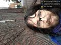
Requisite Silly Grin at hashpoint @42.3696,-71.0805
