Difference between revisions of "2023-01-07 50 8"
(An expedition message sent via Geohash Droid for Android.) |
(expediton added) |
||
| (4 intermediate revisions by 2 users not shown) | |||
| Line 1: | Line 1: | ||
| − | + | {{meetup graticule | |
| − | |||
| − | |||
| − | |||
| − | |||
| − | |||
| − | |||
| − | |||
| − | |||
| lat=50 | | lat=50 | ||
| lon=8 | | lon=8 | ||
| date=2023-01-07 | | date=2023-01-07 | ||
| − | }} | + | | graticule_name=Frankfurt am Main |
| + | | graticule_link=Frankfurt am Main, Germany}} | ||
| + | |||
== Location == | == Location == | ||
<!-- where you've surveyed the hash to be --> | <!-- where you've surveyed the hash to be --> | ||
| + | In a field next to the Nidda in Bad Vilbel. | ||
== Participants == | == Participants == | ||
| − | + | * [[User:Monotof|Monotof]] | |
| − | + | * [[User:GeorgDerReisende|GeorgDerReisende]] | |
== Plans == | == Plans == | ||
| − | + | === Monotof === | |
| + | The Hash point seemed reasonably easy to reach by bike and cycling along the river Nidda is always nice, so i went for it. | ||
| + | === GeorgDerReisende === | ||
| + | I wanted to combine the walk to the hash with a walk through northern parts of Frankfurt. | ||
== Expedition == | == Expedition == | ||
| − | + | === Monotof === | |
| + | ==== To the hash point==== | ||
| + | I started off cycling my normal route to Burgholzhausen, there i went off the main road into the fields. | ||
| + | |||
| + | On the upside, cycling mostly through fields on quiet service roads with sunset views of Frankfurts skyline was pretty nice. | ||
| + | On the downside, there was a decent headwind, which might have been obvious as the route passed directly beneath some wind turbines. Also some of the cycle paths Google Maps and OsmAnd found for me were not well suited for my road bike. | ||
| + | |||
| + | Finally i met the Nidda in Dortelweil, already very close to the hash point. | ||
| + | |||
| + | ==== At the hash point ==== | ||
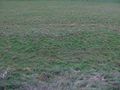
| + | The hash point was in a fallow field (as it is January), next to the river Nidda in Bad Vilbel. There is a foot and cycle path between the field and the Nidda itself. On the other side of the field is the backside of some medium industry buildings of Hassia, a local producer of Mineral Water (and other beverages). It was easy to reach the precise hash point as the field was damp but not too muddy. | ||
| + | |||
| + | After a short snack and tea break i get back on my bike for the ride home. | ||
| + | |||
| + | ==== Back home ==== | ||
| + | Following the Nidda downstream i got to see a bit of the center of Bad Vilbel. Its quite nice and especially the public library looks pretty cool being build above and across the Nidda. | ||
| + | |||
| + | There was some major construction happening at the Train station Bad Vilbel Süd, and i had to alter my route a bit (keeping the Tron challenge in mind). | ||
| + | |||
| + | In Harheim i left the Nidda and instead followed the Eschbach upstream. Both streams were very nice to cycle along. | ||
| + | |||
| + | Finally in Bad Homburg i left the Eschbach and make my way home on my usual bike route from Frankfurt. | ||
| + | === GeorgDerReisende === | ||
| + | ==== On the Run ==== | ||
| + | I started my walk at Bonames and walked via Harheim and Massenheim to Bad Vilbel. At the beginning I had plenty of time but at the end I was running to be at the hash at hash o'clock. | ||
| + | |||
| + | ==== Back home ==== | ||
| + | Astonished I looked to the report of Monotof. We had missed only by some minutes. Looking at my own timestamps I wondered, if I have a photo with him. And I found it. Just as I left the area, I took a photo of it, with the monument. And right off the monument a small red person beyond the dam. (My photos are normalized against the GPSr.) | ||
== Tracklog == | == Tracklog == | ||
| − | + | === Monotof === | |
| + | If the track looks a little too clean: I had to clean up the first half as my phone kept going into a power saving mode and loosing GPS tracking, therefore i fixed the missing parts manually. If necessary you can cross check with the metadata of the photos. | ||
| + | {{tracklog | 2023-01-07 50 8 Bad Vilbel.gpx}} | ||
| + | === GeorgDerReisende === | ||
| + | {{tracklog | 2023-01-07 50 8 GeorgDerReisende 1.gpx }} | ||
== Photos == | == Photos == | ||
| − | + | === Monotof === | |
| − | |||
| − | |||
<gallery perrow="5"> | <gallery perrow="5"> | ||
| + | Image:20230107_50-8_frankfurt_sunset.jpg|Sunset views of Frankfurt am Main | ||
| + | Image:20230107_50-8_wind_turbines.jpg|Wind Turbines | ||
| + | Image:20230107_50-8_bad_path.jpg|Bad path for road bikes | ||
| + | Image:20230107_50-8_Lightcycle_and_Hassia.jpg|My Lightcycle of choice in front of the hash point | ||
| + | Image:20230107_50-8_geohash_reached.jpg|Hash point reached within 0.5 m | ||
| + | Image:20230107_50-8_stupid-grin.jpg|Stupid Grin(TM) | ||
| + | Image:20230107_50-8_Nidda.jpg|View of the Nidda from the footpath near the Geohash | ||
| + | Image:20230107_50-8_constuction_01.jpg|The path is blocked by construction | ||
| + | Image:20230107_50-8_constuction_02.jpg|Taking a bridge over the construction site | ||
| + | </gallery> | ||
| + | === GeorgDerReisende === | ||
| + | <gallery> | ||
| + | File:2023-01-07 50 8 GeorgDerReisende 4663.jpg | the Nidda, the dam and the hash area | ||
| + | File:2023-01-07 50 8 GeorgDerReisende 4664.jpg | the hash from the dam | ||
| + | File:2023-01-07 50 8 GeorgDerReisende 4665.jpg | proof | ||
| + | File:2023-01-07 50 8 GeorgDerReisende 4666.jpg | proof | ||
| + | File:2023-01-07 50 8 GeorgDerReisende 4667.jpg | looking north | ||
| + | File:2023-01-07 50 8 GeorgDerReisende 4668.jpg | east | ||
| + | File:2023-01-07 50 8 GeorgDerReisende 4669.jpg | south | ||
| + | File:2023-01-07 50 8 GeorgDerReisende 4670.jpg | west | ||
| + | File:2023-01-07 50 8 GeorgDerReisende 4671.jpg | Grrr (TM) | ||
| + | File:2023-01-07 50 8 GeorgDerReisende 4675.jpg | the hash area shortly after hash o'clock | ||
| + | File:2023-01-07 50 8 GeorgDerReisende 4683.jpg | the last photo, with Monotof | ||
</gallery> | </gallery> | ||
== Achievements == | == Achievements == | ||
{{#vardefine:ribbonwidth|100%}} | {{#vardefine:ribbonwidth|100%}} | ||
| − | + | {{land geohash | |
| + | | name = [[User:Monotof|Monotof]] | ||
| + | | latitude = 50 | ||
| + | | longitude = 8 | ||
| + | | date = 2023-01-07 | ||
| + | }} | ||
| + | {{bicycle geohash | ||
| + | | name = [[User:Monotof|Monotof]] | ||
| + | | latitude = 50 | ||
| + | | longitude = 8 | ||
| + | | date = 2023-01-07 | ||
| + | | bothways = true | ||
| + | | distance = 31.3 km | ||
| + | }} | ||
| + | {{Tron | ||
| + | | latitude = 50 | ||
| + | | longitude = 8 | ||
| + | | date = 2023-01-07 | ||
| + | | name = [[User:Monotof|Monotof]] | ||
| + | | tracklog = https://geohashing.site/geohashing/File:2023-01-07_50_8_Bad_Vilbel.gpx | ||
| + | | possessive = his | ||
| + | }} | ||
| + | |||
| + | {{xkcd centurion|count=83|name=[[User:GeorgDerReisende|GeorgDerReisende]]}} | ||
__NOTOC__ | __NOTOC__ | ||
| − | |||
| − | |||
| − | |||
| − | |||
| − | |||
| − | |||
| − | |||
| − | |||
| − | |||
| − | |||
| − | |||
| − | |||
| − | |||
[[Category:Expeditions]] | [[Category:Expeditions]] | ||
| − | |||
[[Category:Expeditions with photos]] | [[Category:Expeditions with photos]] | ||
| − | |||
| − | |||
| − | |||
| − | |||
| − | |||
[[Category:Coordinates reached]] | [[Category:Coordinates reached]] | ||
| − | + | {{location|DE|HE|FB}} | |
| − | |||
| − | |||
| − | |||
| − | |||
| − | |||
| − | |||
| − | |||
| − | |||
| − | |||
| − | |||
| − | |||
| − | |||
| − | |||
| − | |||
| − | |||
| − | |||
| − | |||
Latest revision as of 20:21, 9 January 2023
| Sat 7 Jan 2023 in Frankfurt am Main: 50.1945437, 8.7492250 geohashing.info google osm bing/os kml crox |
Location
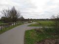
In a field next to the Nidda in Bad Vilbel.
Participants
Plans
Monotof
The Hash point seemed reasonably easy to reach by bike and cycling along the river Nidda is always nice, so i went for it.
GeorgDerReisende
I wanted to combine the walk to the hash with a walk through northern parts of Frankfurt.
Expedition
Monotof
To the hash point
I started off cycling my normal route to Burgholzhausen, there i went off the main road into the fields.
On the upside, cycling mostly through fields on quiet service roads with sunset views of Frankfurts skyline was pretty nice. On the downside, there was a decent headwind, which might have been obvious as the route passed directly beneath some wind turbines. Also some of the cycle paths Google Maps and OsmAnd found for me were not well suited for my road bike.
Finally i met the Nidda in Dortelweil, already very close to the hash point.
At the hash point
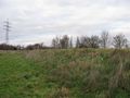
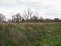
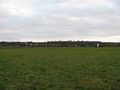
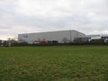
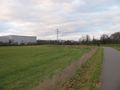
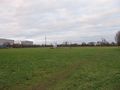
The hash point was in a fallow field (as it is January), next to the river Nidda in Bad Vilbel. There is a foot and cycle path between the field and the Nidda itself. On the other side of the field is the backside of some medium industry buildings of Hassia, a local producer of Mineral Water (and other beverages). It was easy to reach the precise hash point as the field was damp but not too muddy.
After a short snack and tea break i get back on my bike for the ride home.
Back home
Following the Nidda downstream i got to see a bit of the center of Bad Vilbel. Its quite nice and especially the public library looks pretty cool being build above and across the Nidda.
There was some major construction happening at the Train station Bad Vilbel Süd, and i had to alter my route a bit (keeping the Tron challenge in mind).
In Harheim i left the Nidda and instead followed the Eschbach upstream. Both streams were very nice to cycle along.
Finally in Bad Homburg i left the Eschbach and make my way home on my usual bike route from Frankfurt.
GeorgDerReisende
On the Run
I started my walk at Bonames and walked via Harheim and Massenheim to Bad Vilbel. At the beginning I had plenty of time but at the end I was running to be at the hash at hash o'clock.
Back home
Astonished I looked to the report of Monotof. We had missed only by some minutes. Looking at my own timestamps I wondered, if I have a photo with him. And I found it. Just as I left the area, I took a photo of it, with the monument. And right off the monument a small red person beyond the dam. (My photos are normalized against the GPSr.)
Tracklog
Monotof
If the track looks a little too clean: I had to clean up the first half as my phone kept going into a power saving mode and loosing GPS tracking, therefore i fixed the missing parts manually. If necessary you can cross check with the metadata of the photos.
GeorgDerReisende
Photos
Monotof
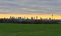
Sunset views of Frankfurt am Main
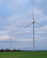
Wind Turbines
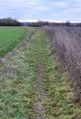
Bad path for road bikes
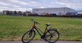
My Lightcycle of choice in front of the hash point

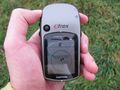
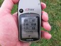
Hash point reached within 0.5 m

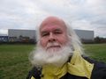
Stupid Grin(TM)
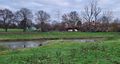
View of the Nidda from the footpath near the Geohash
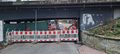
The path is blocked by construction
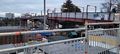
Taking a bridge over the construction site


GeorgDerReisende
the Nidda, the dam and the hash area
the hash from the dam
proof
proof
looking north
east
south
west
Grrr (TM)
the hash area shortly after hash o'clock
the last photo, with Monotof


Achievements
Monotof earned the Land geohash achievement
|
Monotof earned the Bicycle geohash achievement
|
Monotof earned the Tron achievement
|
GeorgDerReisende earned the xkcd Octaginturion achievement
|