Difference between revisions of "2023-01-22 53 7"
FelixTheCat (talk | contribs) |
FelixTheCat (talk | contribs) m (Typo) |
||
| (11 intermediate revisions by 2 users not shown) | |||
| Line 11: | Line 11: | ||
== Expedition == | == Expedition == | ||
| − | I've | + | I've been keeping an eye out for geohashes on the East Frisian Islands for quite a while. Their small size means hashes are very rare, and since they're quite far from my home I would need at least one full day to mount a successful expedition. Fippe already managed to reach Borkum on [[2020-09-17 53 6]], and the (non-East Frisian) island of Helgoland on [[2018-11-29 54 7]]. It was finally my turn to get lucky this weekend: the hash fell on Juist on Sunday, and I didn't have any other plans yet. I immediately began planning my trip, which involved a four-hour drive to a small airfield near Norden followed by a short flight to Juist. |
I got up very early on Sunday morning and drove off at 06:00. The roads were largely empty and I arrived at Norden-Norddeich Airfield with plenty of time to spare. I checked in and then sat in the departure area for about an hour. Eventually only two other passengers showed up. We boarded the aircraft at 11:45, took off, and landed at around 11:50. I then walked towards the hash: first on a path through the dunes, and then along the northern beach. I found the point and took the required pictures. | I got up very early on Sunday morning and drove off at 06:00. The roads were largely empty and I arrived at Norden-Norddeich Airfield with plenty of time to spare. I checked in and then sat in the departure area for about an hour. Eventually only two other passengers showed up. We boarded the aircraft at 11:45, took off, and landed at around 11:50. I then walked towards the hash: first on a path through the dunes, and then along the northern beach. I found the point and took the required pictures. | ||
| − | Then I walked along the beach a bit more and spotted a few seals. I then followed a different path through the dunes back towards the | + | Then I walked along the beach a bit more and spotted a few seals. I then followed a different path through the dunes back towards the airfield. Unfortunately I didn't have time to go to the main village on the island, so I decided to stay at the airfield and wait for my flight back. Luckily I had some snacks with me, because it turned out that the airfield restaurant was closed today. The flight back was nearly full, and because there was a large gentleman in the seat next to me it was uncomfortably cramped. I was glad the flight time was only five minutes. After we landed I got back in the hashmobile and drove all the way back home. |
== Tracklog == | == Tracklog == | ||
| − | + | {{tracklog | 2023-01-22 53 7 FelixTheCat.gpx}} | |
== Photos == | == Photos == | ||
| Line 25: | Line 25: | ||
--> | --> | ||
<gallery perrow="5"> | <gallery perrow="5"> | ||
| − | Image:2023-01-22 53 7 FelixTheCat 1.JPG | Preparing my trip the day before. | + | Image:2023-01-22 53 7 FelixTheCat 1.JPG | Preparing my trip on the day before. |
Image:2023-01-22 53 7 FelixTheCat 2.JPG | On the way to Norddeich I stopped in Suurhusen to visit [https://en.wikipedia.org/wiki/Leaning_Tower_of_Suurhusen its leaning tower], apparently the most inclined tower in the world. | Image:2023-01-22 53 7 FelixTheCat 2.JPG | On the way to Norddeich I stopped in Suurhusen to visit [https://en.wikipedia.org/wiki/Leaning_Tower_of_Suurhusen its leaning tower], apparently the most inclined tower in the world. | ||
Image:2023-01-22 53 7 FelixTheCat 3.JPG | At Norddeich I climbed up the dyke and looked out over the Wadden Sea. Juist is already visible. | Image:2023-01-22 53 7 FelixTheCat 3.JPG | At Norddeich I climbed up the dyke and looked out over the Wadden Sea. Juist is already visible. | ||
Image:2023-01-22 53 7 FelixTheCat 4.JPG | Looking south, we see Norden-Norddeich Airfield (IATA:NOE). | Image:2023-01-22 53 7 FelixTheCat 4.JPG | Looking south, we see Norden-Norddeich Airfield (IATA:NOE). | ||
Image:2023-01-22 53 7 FelixTheCat 5.JPG | The terminal is a small building. | Image:2023-01-22 53 7 FelixTheCat 5.JPG | The terminal is a small building. | ||
| − | Image:2023-01-22 53 7 FelixTheCat 6.JPG | Enjoying my complimentary | + | Image:2023-01-22 53 7 FelixTheCat 6.JPG | Enjoying my complimentary hot beverage in the departure lounge. |
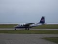
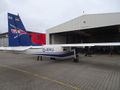
Image:2023-01-22 53 7 FelixTheCat 7.JPG | Our aircraft for today: a Britten-Norman BN-2 Islander, registration D-IFKU. | Image:2023-01-22 53 7 FelixTheCat 7.JPG | Our aircraft for today: a Britten-Norman BN-2 Islander, registration D-IFKU. | ||
Image:2023-01-22 53 7 FelixTheCat 8.JPG | Our pilot preparing for takeoff. | Image:2023-01-22 53 7 FelixTheCat 8.JPG | Our pilot preparing for takeoff. | ||
| Line 36: | Line 36: | ||
Image:2023-01-22 53 7 FelixTheCat 10.JPG | Our pilot preparing for landing. | Image:2023-01-22 53 7 FelixTheCat 10.JPG | Our pilot preparing for landing. | ||
Image:2023-01-22 53 7 FelixTheCat 11.JPG | I took this path through the dunes to end up on the northern beach. | Image:2023-01-22 53 7 FelixTheCat 11.JPG | I took this path through the dunes to end up on the northern beach. | ||
| − | Image:2023-01-22 53 7 FelixTheCat 12.JPG | It's a very wide beach. There | + | Image:2023-01-22 53 7 FelixTheCat 12.JPG | It's a very wide beach. There was a nasty cold wind, but there were quite a few people walking. |
Image:2023-01-22 53 7 FelixTheCat 13.JPG | The hash is in front of us. | Image:2023-01-22 53 7 FelixTheCat 13.JPG | The hash is in front of us. | ||
Image:2023-01-22 53 7 FelixTheCat 14.png | GPS proof. | Image:2023-01-22 53 7 FelixTheCat 14.png | GPS proof. | ||
Image:2023-01-22 53 7 FelixTheCat 15.JPG | Lloyd and Harriet celebrating. | Image:2023-01-22 53 7 FelixTheCat 15.JPG | Lloyd and Harriet celebrating. | ||
| − | Image:2023-01-22 53 7 FelixTheCat 16.JPG | Looking east, towards the | + | Image:2023-01-22 53 7 FelixTheCat 16.JPG | Looking east, towards the neighbouring island of Norderney. |
Image:2023-01-22 53 7 FelixTheCat 17.JPG | Looking south at the dunes. | Image:2023-01-22 53 7 FelixTheCat 17.JPG | Looking south at the dunes. | ||
Image:2023-01-22 53 7 FelixTheCat 18.JPG | A bit further along the beach I saw this seal. Seals shouldn't be disturbed, so I kept my distance and used the zoom function on my camera to snap this picture. | Image:2023-01-22 53 7 FelixTheCat 18.JPG | A bit further along the beach I saw this seal. Seals shouldn't be disturbed, so I kept my distance and used the zoom function on my camera to snap this picture. | ||
Image:2023-01-22 53 7 FelixTheCat 19.JPG | The path back to the airfield. It was flooded along most of its length. | Image:2023-01-22 53 7 FelixTheCat 19.JPG | The path back to the airfield. It was flooded along most of its length. | ||
| − | Image:2023-01-22 53 7 FelixTheCat 20.JPG | Back at the | + | Image:2023-01-22 53 7 FelixTheCat 20.JPG | Back at the airfield. The only restaurant was sadly closed. |
Image:2023-01-22 53 7 FelixTheCat 21.JPG | This waiting room was open however, so I rested my legs and had a small snack. | Image:2023-01-22 53 7 FelixTheCat 21.JPG | This waiting room was open however, so I rested my legs and had a small snack. | ||
Image:2023-01-22 53 7 FelixTheCat 22.JPG | Our aircraft is back. | Image:2023-01-22 53 7 FelixTheCat 22.JPG | Our aircraft is back. | ||
Image:2023-01-22 53 7 FelixTheCat 23.JPG | It's quite cramped when fully loaded. | Image:2023-01-22 53 7 FelixTheCat 23.JPG | It's quite cramped when fully loaded. | ||
Image:2023-01-22 53 7 FelixTheCat 24.JPG | The port of Norddeich seen from the air. This is where the ferry to Juist leaves. | Image:2023-01-22 53 7 FelixTheCat 24.JPG | The port of Norddeich seen from the air. This is where the ferry to Juist leaves. | ||
| − | Image:2023-01-22 53 7 FelixTheCat 25.JPG | Back on the ground, ready for the | + | Image:2023-01-22 53 7 FelixTheCat 25.JPG | Back on the ground, ready for the four-hour drive home. |
</gallery> | </gallery> | ||
== Achievements == | == Achievements == | ||
{{#vardefine:ribbonwidth|100%}} | {{#vardefine:ribbonwidth|100%}} | ||
| − | + | {{land geohash | |
| − | + | | latitude = 53 | |
| − | + | | longitude = 7 | |
| − | + | | date = 2023-01-22 | |
| − | + | | name = [[User:FelixTheCat|FelixTheCat]] ([[User talk:FelixTheCat|talk]]) | |
| − | [[ | + | }} |
| − | + | {{Border geohash achievement | |
| − | + | | latitude = 53 | |
| − | + | | longitude = 7 | |
| − | + | | date = 2023-01-22 | |
| − | + | | country1 = Dutch | |
| − | + | | country2 = German | |
| − | + | | name = [[User:FelixTheCat|FelixTheCat]] ([[User talk:FelixTheCat|talk]]) | |
| − | + | }} | |
| − | |||
| − | |||
| − | |||
[[Category:Expeditions]] | [[Category:Expeditions]] | ||
| − | |||
[[Category:Expeditions with photos]] | [[Category:Expeditions with photos]] | ||
| − | |||
| − | |||
| − | |||
| − | |||
| − | |||
[[Category:Coordinates reached]] | [[Category:Coordinates reached]] | ||
| − | + | {{location|DE|NI|AUR}} | |
| − | |||
| − | |||
| − | |||
| − | |||
| − | |||
| − | |||
| − | |||
| − | |||
| − | |||
| − | |||
| − | |||
| − | |||
| − | |||
| − | |||
| − | |||
| − | |||
| − | |||
Latest revision as of 08:06, 26 January 2023
| Sun 22 Jan 2023 in 53,7: 53.6875241, 7.0802566 geohashing.info google osm bing/os kml crox |
Location
On the island of Juist, Lower Saxony, Germany.
Participants
Expedition
I've been keeping an eye out for geohashes on the East Frisian Islands for quite a while. Their small size means hashes are very rare, and since they're quite far from my home I would need at least one full day to mount a successful expedition. Fippe already managed to reach Borkum on 2020-09-17 53 6, and the (non-East Frisian) island of Helgoland on 2018-11-29 54 7. It was finally my turn to get lucky this weekend: the hash fell on Juist on Sunday, and I didn't have any other plans yet. I immediately began planning my trip, which involved a four-hour drive to a small airfield near Norden followed by a short flight to Juist.
I got up very early on Sunday morning and drove off at 06:00. The roads were largely empty and I arrived at Norden-Norddeich Airfield with plenty of time to spare. I checked in and then sat in the departure area for about an hour. Eventually only two other passengers showed up. We boarded the aircraft at 11:45, took off, and landed at around 11:50. I then walked towards the hash: first on a path through the dunes, and then along the northern beach. I found the point and took the required pictures.
Then I walked along the beach a bit more and spotted a few seals. I then followed a different path through the dunes back towards the airfield. Unfortunately I didn't have time to go to the main village on the island, so I decided to stay at the airfield and wait for my flight back. Luckily I had some snacks with me, because it turned out that the airfield restaurant was closed today. The flight back was nearly full, and because there was a large gentleman in the seat next to me it was uncomfortably cramped. I was glad the flight time was only five minutes. After we landed I got back in the hashmobile and drove all the way back home.
Tracklog
Photos
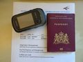
Preparing my trip on the day before.
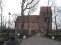
On the way to Norddeich I stopped in Suurhusen to visit its leaning tower, apparently the most inclined tower in the world.
At Norddeich I climbed up the dyke and looked out over the Wadden Sea. Juist is already visible.
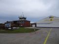
Looking south, we see Norden-Norddeich Airfield (IATA:NOE).
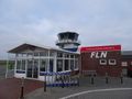
The terminal is a small building.
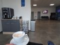
Enjoying my complimentary hot beverage in the departure lounge.
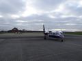
Our aircraft for today: a Britten-Norman BN-2 Islander, registration D-IFKU.
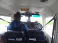
Our pilot preparing for takeoff.
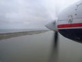
Juist comes into view, with its airfield (IATA:JUI) and the hashpoint on the beach behind it.
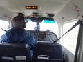
Our pilot preparing for landing.
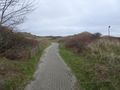
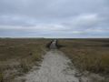
I took this path through the dunes to end up on the northern beach.
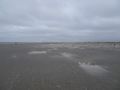
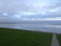
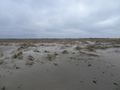
It's a very wide beach. There was a nasty cold wind, but there were quite a few people walking.
The hash is in front of us.
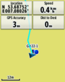
GPS proof.
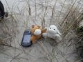
Lloyd and Harriet celebrating.
Looking east, towards the neighbouring island of Norderney.
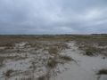
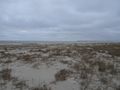
Looking south at the dunes.
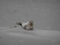
A bit further along the beach I saw this seal. Seals shouldn't be disturbed, so I kept my distance and used the zoom function on my camera to snap this picture.
The path back to the airfield. It was flooded along most of its length.
Back at the airfield. The only restaurant was sadly closed.
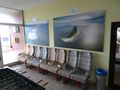
This waiting room was open however, so I rested my legs and had a small snack.
Our aircraft is back.
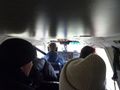
It's quite cramped when fully loaded.
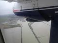
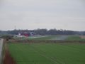
The port of Norddeich seen from the air. This is where the ferry to Juist leaves.
Back on the ground, ready for the four-hour drive home.


Achievements
FelixTheCat (talk) earned the Land geohash achievement
|
FelixTheCat (talk) earned the Border geohash achievement
|