Difference between revisions of "2023-02-11 43 -79"
From Geohashing
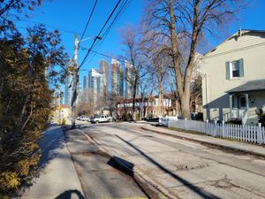
([retro picture]This tree is at the hashpoint) |
m (Location) |
||
| (3 intermediate revisions by one other user not shown) | |||
| Line 1: | Line 1: | ||
| − | + | [[Image:{{{image|2023-02-11 43 -79 frogman 1676383481262.jpg}}}|thumb|left]] | |
| − | + | {{meetup graticule | |
| − | |||
| − | |||
| − | |||
| − | |||
| − | |||
| − | |||
| lat=43 | | lat=43 | ||
| lon=-79 | | lon=-79 | ||
| Line 13: | Line 7: | ||
}}<!-- edit as necessary --> | }}<!-- edit as necessary --> | ||
== Location == | == Location == | ||
| − | + | On a sidewalk by a school in Mimico. | |
== Participants == | == Participants == | ||
| − | + | *[[User:Frogman|Frogman]] | |
| − | + | *Wyatt | |
| − | + | *Keenan | |
| − | |||
| − | |||
== Expedition == | == Expedition == | ||
| − | + | Wyatt and I met up at Old Mill subway station and walked south along the Humber River Trail. Keenan met us at The Queensway and joined us for the expedition. | |
| − | + | The hashpoint itself was on a sidewalk in front of David Hornell Junior School. We snapped a couple pictures, hung out a bit, and then left for a walk along the lake shore. It was nice! | |
| − | |||
== Photos == | == Photos == | ||
| Line 39: | Line 30: | ||
Image:2023-02-11_43_-79_frogman_1676383524514.jpg|This tree is at the hashpoint | Image:2023-02-11_43_-79_frogman_1676383524514.jpg|This tree is at the hashpoint | ||
| + | |||
| + | Image:2023-02-11_43_-79_frogman_1676383547309.jpg|The geohashers! | ||
| + | |||
| + | Image:2023-02-11_43_-79_frogman_1676383562348.jpg|Checking out a nearby playground | ||
</gallery> | </gallery> | ||
== Achievements == | == Achievements == | ||
{{#vardefine:ribbonwidth|100%}} | {{#vardefine:ribbonwidth|100%}} | ||
| − | + | {{drag-along | |
| − | + | | latitude = 43 | |
| − | + | | longitude = -79 | |
| − | + | | date = 2023-02-11 | |
| − | [[ | + | | partner = Keenan |
| + | | name = Wyatt and [[User:Frogman|Frogman]] | ||
| − | + | }} | |
| − | + | __NOTOC__ | |
| − | |||
| − | |||
| − | |||
| − | |||
| − | |||
| − | |||
| − | |||
[[Category:Expeditions]] | [[Category:Expeditions]] | ||
| − | |||
[[Category:Expeditions with photos]] | [[Category:Expeditions with photos]] | ||
| − | |||
| − | |||
| − | |||
| − | |||
| − | |||
[[Category:Coordinates reached]] | [[Category:Coordinates reached]] | ||
| − | + | {{location|CA|ON|TO}} | |
| − | |||
| − | |||
| − | |||
| − | |||
| − | |||
| − | |||
| − | |||
| − | |||
| − | |||
| − | |||
| − | |||
| − | |||
| − | |||
| − | |||
| − | |||
| − | |||
| − | |||
Latest revision as of 14:42, 14 February 2023
| Sat 11 Feb 2023 in 43,-79: 43.6191979, -79.4883106 geohashing.info google osm bing/os kml crox |
Location
On a sidewalk by a school in Mimico.
Participants
- Frogman
- Wyatt
- Keenan
Expedition
Wyatt and I met up at Old Mill subway station and walked south along the Humber River Trail. Keenan met us at The Queensway and joined us for the expedition.
The hashpoint itself was on a sidewalk in front of David Hornell Junior School. We snapped a couple pictures, hung out a bit, and then left for a walk along the lake shore. It was nice!
Photos
Achievements
Wyatt and Frogman earned the Drag-along achievement
|


