Difference between revisions of "2023-02-19 56 -2"
From Geohashing
m (subst-ing) |
|||
| (6 intermediate revisions by 3 users not shown) | |||
| Line 8: | Line 8: | ||
And DON'T FORGET to add your expedition and the best photo you took to the gallery on the Main Page! We'd love to read your report, but that means we first have to discover it! :) | And DON'T FORGET to add your expedition and the best photo you took to the gallery on the Main Page! We'd love to read your report, but that means we first have to discover it! :) | ||
-->{{meetup graticule | -->{{meetup graticule | ||
| − | | lat= | + | | lat=56 |
| − | | lon= | + | | lon=-2 |
| − | | date= | + | | date=2023-02-19 |
}}<!-- edit as necessary --> | }}<!-- edit as necessary --> | ||
== Location == | == Location == | ||
| Line 38: | Line 38: | ||
[[File:hash2023-02-19.jpg|400px]] | [[File:hash2023-02-19.jpg|400px]] | ||
| − | There are no sidewalks out here, I'm running on awkwardly sloped grass verges where possible while cars go by, it's not a great time, would not run at Ethiebeaton Farm and Drumsturdy Road again. Headed back for the city as soon as possible. | + | There are no sidewalks out here, I'm running on awkwardly sloped grass verges where possible while cars go by, it's not a great time, would not run at Ethiebeaton Farm and Drumsturdy Road again. Headed back for the city as soon as possible, giving up my tron plans. |
| − | |||
== Tracklog == | == Tracklog == | ||
<!-- if your GPS device keeps a log, you may use Template:Tracklog, post a link here, or both --> | <!-- if your GPS device keeps a log, you may use Template:Tracklog, post a link here, or both --> | ||
<gallery perrow="5"> | <gallery perrow="5"> | ||
| − | Image: | + | Image:2023-02-19 56 -2 Garmin.png | garmin trace |
Image:Screenshot_20230219-104820_Geohash_Droid.png | geohash droid | Image:Screenshot_20230219-104820_Geohash_Droid.png | geohash droid | ||
| − | Image:busroutedraw_20230218-172231.png| Bus route + run path | + | Image:busroutedraw_20230218-172231.png| Bus route + run path: no tron |
</gallery> | </gallery> | ||
| + | |||
== Photos == | == Photos == | ||
<!-- Insert pictures between the gallery tags using the following format: | <!-- Insert pictures between the gallery tags using the following format: | ||
| Line 70: | Line 70: | ||
}} | }} | ||
| − | |||
| − | |||
| − | |||
| − | |||
| − | |||
| − | |||
| − | |||
| − | |||
| − | |||
| − | |||
__NOTOC__ | __NOTOC__ | ||
<!-- =============== USEFUL CATEGORIES FOLLOW ================ | <!-- =============== USEFUL CATEGORIES FOLLOW ================ | ||
Delete the next line ONLY if you have chosen the appropriate categories below. If you are unsure, don't worry. People will read your report and help you with the classification. --> | Delete the next line ONLY if you have chosen the appropriate categories below. If you are unsure, don't worry. People will read your report and help you with the classification. --> | ||
| − | |||
<!-- ==REQUEST FOR TWITTER BOT== Please leave either the New report or the Expedition planning category in as long as you work on it. This helps the twitter bot a lot with announcing the right outcome at the right moment. --> | <!-- ==REQUEST FOR TWITTER BOT== Please leave either the New report or the Expedition planning category in as long as you work on it. This helps the twitter bot a lot with announcing the right outcome at the right moment. --> | ||
| Line 92: | Line 81: | ||
[[Category:Expeditions]] | [[Category:Expeditions]] | ||
| − | + | [[Category:Expeditions with photos]] | |
[[Category:Coordinates reached]] | [[Category:Coordinates reached]] | ||
| + | {{location|GB|SCT|ANS}} | ||
Latest revision as of 20:56, 24 May 2024
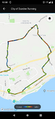
| Sun 19 Feb 2023 in 56,-2: 56.4963914, -2.8446142 geohashing.info google osm bing/os kml crox |
Location
Ethiebeaton, just east of Dundee
Participants
Plans
Bus to Broughty Ferry, 5km run to the spot, 13km run home by a different route.
Expedition
Run from Broughty Ferry to the spot, easy. Thanks Monifieth path network. Discovered Seven Arches Viaduct.
Gallow Hill, a quarry site

It's in this dwelling's parking bay

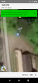
The spot

There are no sidewalks out here, I'm running on awkwardly sloped grass verges where possible while cars go by, it's not a great time, would not run at Ethiebeaton Farm and Drumsturdy Road again. Headed back for the city as soon as possible, giving up my tron plans.
Tracklog
garmin trace
geohash droid
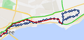
Bus route + run path: no tron


Photos
Achievements
jsk earned the Land geohash achievement
|