Difference between revisions of "2023-03-03 58 5"
From Geohashing
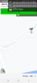
([live picture]Bollestad [https://openstreetmap.org/?mlat=58.76012600&mlon=5.89457080&zoom=16 @58.7601,5.8946]) |
(→Achievements) |
||
| (7 intermediate revisions by the same user not shown) | |||
| Line 12: | Line 12: | ||
| date=2023-03-03 | | date=2023-03-03 | ||
}}<!-- edit as necessary --> | }}<!-- edit as necessary --> | ||
| + | [[Image:20230303 58-5-Me.jpg|thumb|left]] | ||
| + | |||
== Location == | == Location == | ||
<!-- where you've surveyed the hash to be --> | <!-- where you've surveyed the hash to be --> | ||
| + | |||
| + | On a tractor road on the farm Bollestad, Ålgård, Gjesdal, Norway | ||
== Participants == | == Participants == | ||
<!-- who attended: If you link to your wiki user name in this section, your expedition will be picked up by the various statistics generated for geohashing. You may use three tildes ~ as a shortcut to automatically insert the user signature of the account you are editing with. | <!-- who attended: If you link to your wiki user name in this section, your expedition will be picked up by the various statistics generated for geohashing. You may use three tildes ~ as a shortcut to automatically insert the user signature of the account you are editing with. | ||
--> | --> | ||
| + | |||
| + | *[[User:Pica42|Pica42]] | ||
== Plans == | == Plans == | ||
| Line 24: | Line 30: | ||
== Expedition == | == Expedition == | ||
<!-- how it all turned out. your narrative goes here. --> | <!-- how it all turned out. your narrative goes here. --> | ||
| + | |||
| + | This was a lovely day to find a hash point. First I drove about 21 km, and from where I parked to the hash it was only about 100 meters to walk. The hash was roughly in the middle of a tractor road. | ||
== Tracklog == | == Tracklog == | ||
| Line 35: | Line 43: | ||
Image:2023-03-03_58_5_Pica42_1677830685926.jpg|Bollestad [https://openstreetmap.org/?mlat=58.76012600&mlon=5.89457080&zoom=16 @58.7601,5.8946] | Image:2023-03-03_58_5_Pica42_1677830685926.jpg|Bollestad [https://openstreetmap.org/?mlat=58.76012600&mlon=5.89457080&zoom=16 @58.7601,5.8946] | ||
| + | Image:20230303 58-5-NE.jpg|thumb|View to the northeast. | ||
| + | Image:20230303 58-56-SW.jpg|thumb|View to the southwest. | ||
</gallery> | </gallery> | ||
| Line 41: | Line 51: | ||
<!-- Add any achievement ribbons you earned below, or remove this section --> | <!-- Add any achievement ribbons you earned below, or remove this section --> | ||
| − | + | {{land geohash |name=[[User:Pica42|Pica42]] |date=2023-03-03 |latitude=58 |longitude=5 }} | |
| − | |||
| − | |||
| − | [[ | ||
| − | |||
| − | |||
| − | |||
| − | |||
| − | |||
| − | |||
| − | |||
| − | |||
| − | |||
| − | |||
| − | |||
[[Category:Expeditions]] | [[Category:Expeditions]] | ||
| − | |||
[[Category:Expeditions with photos]] | [[Category:Expeditions with photos]] | ||
| − | |||
| − | |||
| − | |||
| − | |||
| − | |||
[[Category:Coordinates reached]] | [[Category:Coordinates reached]] | ||
| + | {{location|NO|11}} | ||
| − | + | __NOTOC__ | |
| − | |||
| − | |||
| − | |||
| − | |||
| − | |||
| − | |||
| − | |||
| − | |||
| − | |||
| − | |||
| − | |||
| − | |||
| − | |||
| − | |||
| − | |||
Latest revision as of 09:34, 3 March 2023
| Fri 3 Mar 2023 in 58,5: 58.7601819, 5.8945609 geohashing.info google osm bing/os kml crox |

Location
On a tractor road on the farm Bollestad, Ålgård, Gjesdal, Norway
Participants
Plans
Expedition
This was a lovely day to find a hash point. First I drove about 21 km, and from where I parked to the hash it was only about 100 meters to walk. The hash was roughly in the middle of a tractor road.
Tracklog
Photos
Bollestad @58.7601,5.8946
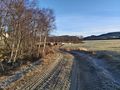
View to the northeast.
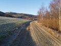
View to the southwest.


Achievements
Pica42 earned the Land geohash achievement
|