Difference between revisions of "2023-03-15 64 25"
m (subst-ing) |
|||
| (2 intermediate revisions by one other user not shown) | |||
| Line 1: | Line 1: | ||
{{meetup graticule | {{meetup graticule | ||
| − | | lat= | + | | lat=64 |
| − | | lon= | + | | lon=25 |
| − | | date= | + | | date=2023-03-15 |
}} | }} | ||
== Location == | == Location == | ||
| Line 10: | Line 10: | ||
{{MapSiteLink | {{MapSiteLink | ||
| lat = 64.9922765 | lon = 25.4638556 | | lat = 64.9922765 | lon = 25.4638556 | ||
| − | | title = Geohash+ | + | | title = Geohash+2023-03-15+64+25 |
}} | }} | ||
| Line 35: | Line 35: | ||
I continued jogging to Äimärautio and back to Mäntylä. | I continued jogging to Äimärautio and back to Mäntylä. | ||
Making sure I would not fail the Tron achievement back in the yard was very easy because my footprints were clearly visible in the fresh snow. | Making sure I would not fail the Tron achievement back in the yard was very easy because my footprints were clearly visible in the fresh snow. | ||
| + | I cut out the beginning and the end of the tracklog so I would not reveal my exact home location, but disregarding noise the tracklog does not cross itself on the yard either. | ||
I ended up traversing a distance of 5.6 kilometres. | I ended up traversing a distance of 5.6 kilometres. | ||
According to the GPS receiver, my average speed was 7.5 km/h while moving and 6.1 km/h overall. | According to the GPS receiver, my average speed was 7.5 km/h while moving and 6.1 km/h overall. | ||
The whole trip took a little less than an hour. | The whole trip took a little less than an hour. | ||
| − | |||
== Tracklog == | == Tracklog == | ||
| Line 59: | Line 59: | ||
{{Land geohash | {{Land geohash | ||
| name = [[User:Kripakko|Kripakko]] | | name = [[User:Kripakko|Kripakko]] | ||
| − | | latitude = | + | | latitude = 64 | longitude = 25 | date = 2023-03-15 |
}} | }} | ||
{{Walk geohash | {{Walk geohash | ||
| name = [[User:Kripakko|Kripakko]] | distance = 5.6 km | | name = [[User:Kripakko|Kripakko]] | distance = 5.6 km | ||
| − | | latitude = | + | | latitude = 64 | longitude = 25 | date = 2023-03-15 |
}} | }} | ||
{{Tron | {{Tron | ||
| name = [[User:Kripakko|Kripakko]] | possessive = his | tracklog = https://geohashing.site/geohashing/File:2023-03-05_64_25_tracklog.gpx | | name = [[User:Kripakko|Kripakko]] | possessive = his | tracklog = https://geohashing.site/geohashing/File:2023-03-05_64_25_tracklog.gpx | ||
| − | | latitude = | + | | latitude = 64 | longitude = 25 | date = 2023-03-15 |
}} | }} | ||
{{Frozen geohash | {{Frozen geohash | ||
| name = [[User:Kripakko|Kripakko]] | temperature = −6 °C | | name = [[User:Kripakko|Kripakko]] | temperature = −6 °C | ||
| − | | latitude = | + | | latitude = 64 | longitude = 25 | date = 2023-03-15 |
}} | }} | ||
Latest revision as of 20:57, 24 May 2024
| Wed 15 Mar 2023 in 64,25: 64.9922765, 25.4638556 geohashing.info google osm bing/os kml crox |
Location
On Kallisensuora street in Limingantulli, Oulu.
The point on a topographic map: [1]
Participants
Plans
About two kilometres from home, in the middle of a street. Since there are many shops, stores and businesses in this area, there is usually a lot of traffic in the daytime. Therefore, I will go walking or cycling at night when it is quiet.
Expedition
I decided to go on foot and to do a Tron achievement since it would be trivial to do. It was snowing fairly heavily, and there were several centimetres of fresh powder snow everywhere, but it was not too much. I jogged most of the way (maybe about three fourths of the distance) and walked sometimes when I felt tired or needed to look at my phone or the GPS receiver. I went from Mäntylä to Lintula, Höyhtyä and Nokela and finally to Limingantulli where I found the hashpoint with barely any effort.
Even though it was already past 11 pm, there was still some traffic that I had to mind: some people were driving to and from the fuel station. Once there was a quiet moment, I went and took a couple of quick photos and ran across the road. I then sprinted to and over Limingantie road along a not exactly legal route because there were no better alternatives. I did not inconvenience anyone else though, so it is fine. I continued jogging to Äimärautio and back to Mäntylä. Making sure I would not fail the Tron achievement back in the yard was very easy because my footprints were clearly visible in the fresh snow. I cut out the beginning and the end of the tracklog so I would not reveal my exact home location, but disregarding noise the tracklog does not cross itself on the yard either.
I ended up traversing a distance of 5.6 kilometres. According to the GPS receiver, my average speed was 7.5 km/h while moving and 6.1 km/h overall. The whole trip took a little less than an hour.
Tracklog
Photos
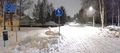
A crossroads on the way. You can really see against the light how it is snowing.
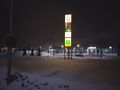
The Prisma megastore and the ABC fuel station near the hashpoint.
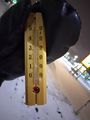
Proof of temperature (−6 °C).
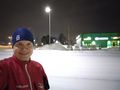
Selfie near the hashpoint. It was located on the road behind me.
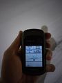
At the hashpoint, proof of location.
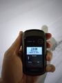
Proof of date and time.


Achievements
Kripakko earned the Land geohash achievement
|
Kripakko earned the Walk geohash Achievement
|
Kripakko earned the Tron achievement
|
