Difference between revisions of "2023-04-07 47 7"
m (Location) |
(Coordinates reached) |
||
| (One intermediate revision by the same user not shown) | |||
| Line 11: | Line 11: | ||
== Plans == | == Plans == | ||
| − | [[User:Baarde|Baarde]] will take the train from Sélestat to Mulhouse, then cycle to the geohash. He expects to arrive | + | [[User:Baarde|Baarde]] will take the train from Sélestat to Mulhouse, then cycle to the geohash. He expects to arrive around 19:30. |
| + | |||
| + | == Expedition == | ||
| + | I finished working earlier than usual today. So I had enough time to go geohashing in the evening. | ||
| + | |||
| + | I cycled from Mulhouse train station to Sausheim, then took a narrow path that goes around a gravel pit, over the A35 highway and a canal, to the Hardt forest. After a couple of kilometers in the forest, I left my bicycle and walked about 200 meters through the woods. The coordinates were located in a thicket of small trees. | ||
| + | |||
| + | After recording proof, I cycled back to the train station and went home. | ||
| + | |||
| + | == Photos == | ||
| + | <gallery> | ||
| + | File:2023-04-07 47 7 01.jpg | In Mulhouse | ||
| + | File:2023-04-07 47 7 02.jpg | In Sausheim | ||
| + | File:2023-04-07 47 7 03.jpg | Over the highway | ||
| + | File:2023-04-07 47 7 04.jpg | On a narrow path | ||
| + | File:2023-04-07 47 7 05.jpg | Over the canal | ||
| + | File:2023-04-07 47 7 06.jpg | In the Hardt forest | ||
| + | File:2023-04-07 47 7 07.jpg | Stupid grin | ||
| + | File:2023-04-07 47 7 08.png | Coordinates reached | ||
| + | File:2023-04-07 47 7 09.jpg | There used to be a path here | ||
| + | </gallery> | ||
| + | |||
| + | == Achievements == | ||
| + | {{#vardefine:ribbonwidth|100%}} | ||
| + | {{land geohash | ||
| + | | latitude = 47 | ||
| + | | longitude = 7 | ||
| + | | date = 2023-04-07 | ||
| + | | name = [[User:Baarde|Baarde]] | ||
| + | }} | ||
__NOTOC__ | __NOTOC__ | ||
[[Category:Expeditions]] | [[Category:Expeditions]] | ||
| + | [[Category:Expeditions with photos]] | ||
| + | [[Category:Coordinates reached]] | ||
{{location|FR|68}} | {{location|FR|68}} | ||
Latest revision as of 19:56, 10 April 2023
| Fri 7 Apr 2023 in 47,7: 47.7864111, 7.4120822 geohashing.info google osm bing/os kml crox |
Location
In the Hardt forest, near Sausheim.
Participants
Plans
Baarde will take the train from Sélestat to Mulhouse, then cycle to the geohash. He expects to arrive around 19:30.
Expedition
I finished working earlier than usual today. So I had enough time to go geohashing in the evening.
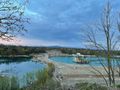
I cycled from Mulhouse train station to Sausheim, then took a narrow path that goes around a gravel pit, over the A35 highway and a canal, to the Hardt forest. After a couple of kilometers in the forest, I left my bicycle and walked about 200 meters through the woods. The coordinates were located in a thicket of small trees.
After recording proof, I cycled back to the train station and went home.
Photos

In Mulhouse
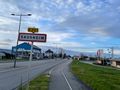
In Sausheim
Over the highway
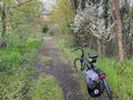
On a narrow path
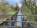
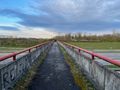
Over the canal
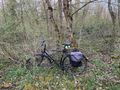
In the Hardt forest

Stupid grin

Coordinates reached
There used to be a path here


Achievements
Baarde earned the Land geohash achievement
|