Difference between revisions of "2023-04-08 -37 145"
(An expedition message sent via Geohash Droid for Android.) |
m (Location) |
||
| (23 intermediate revisions by 2 users not shown) | |||
| Line 1: | Line 1: | ||
| − | + | {{meetup graticule | |
| − | |||
| − | |||
| − | |||
| − | |||
| − | |||
| − | |||
| − | |||
| − | |||
| lat=-37 | | lat=-37 | ||
| lon=145 | | lon=145 | ||
| date=2023-04-08 | | date=2023-04-08 | ||
| − | }} | + | }} |
== Location == | == Location == | ||
| − | + | On a footpath in Wheelers Hill, 190m off the route of our planned bike ride for the day. | |
== Participants == | == Participants == | ||
| − | + | *[[User:Lachie|Lachie]] | |
| − | + | *[[User:LauraG|Laura]] | |
== Plans == | == Plans == | ||
| − | + | The weather forecast for Melbourne over the Easter long weekend was grim. Thunderstorms all day, every day. Laura and I had plans to visit Ferntree Gully and Upwey for family gatherings. I like bike riding but in weather this bad I would usually catch a train instead. | |
| + | |||
| + | The train forecast for Melbourne over the Easter long weekend (and decent chunks of surrounding months) was grim. Rail replacement buses all day, every day on sections of the Belydale (Belgrave/Lilydale) lines. Laura and I had plans to visit Ferntree Gully and the Upwey for family gatherings. I like train riding but in buses this bad I would usually catch a bike instead. | ||
| + | |||
| + | We formulated a hybrid approach where we would ride to Ferntree Gully, accepting our fate that we would be soggy for lunch. Then in the evening we would catch trains back to Box Hill and ride home from there. | ||
| + | |||
| + | When geohashing coordinates for the day our plans barely altered at all. We added 15 minutes to our schedule and each packed a beer. | ||
== Expedition == | == Expedition == | ||
| − | + | I set out from home on my single speed with a handlebar bag under my saddle. The roads were dirty but the sky was blue. I found Laura on a velodrome and we rode out to Wheelers Hill together. As we arrived in Wheelers HIll it started to rain but it didn't matter because we were under cover. | |
| + | |||
| + | We paused to hunt for some easter rabbits then started the descent down the infamous Ferntree Gully Road hill. Half way down the hill we turned off down a side street, made a couple more turns, spotted a geohasher's* parents' house in the distance and then easily found the geohash on the footpath. | ||
| + | |||
| + | We then went across the road to Jells Park for a celebratory 10:30am beer. With perfect timing, just as we arrived under a tree it started bucketing down but it didn't matter because we were under cover. We waited out the storm and then continued our journey. There was another sprinkle of rain but we made it to lunch basically dry. | ||
| + | |||
| + | It rained loudly through lunch but it didn't matter because we were under cover. The rain stopped again in time for us to depart. With a few extra family members in tow we then visited the delightful new Hard Road Brewery in Bayswater. Highly recommended. It rained again, even louder this time but it didn't matter because we were under cover. Again the rain stopped in time for us to head up the hill. | ||
| + | |||
| + | The ride up to Upwey was a long slog on the single speed so Laura ditched me at the bottom of the hill. I did make it up eventually and there was only one little pinch where I had to walk 10 steps. After I arrived it rained again but it didn't matter because we were under cover. | ||
| + | |||
| + | From there we took two trains to Box Hill and rode our separate ways. The rain did finally catch up to us and I arrived home rather wet. | ||
| + | |||
| + | <span>*</span>For privacy reasons I will not disclose who the geohasher is, but I will say they were not present on this expedition. | ||
== Tracklog == | == Tracklog == | ||
| − | + | {{ Tracklog | 2023-04-08 -37 145 Wheelers Hill Geohash.gpx }} | |
== Photos == | == Photos == | ||
| − | |||
| − | |||
| − | |||
<gallery perrow="5"> | <gallery perrow="5"> | ||
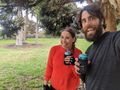
| + | Image:2023-04-08_-37_145_lachie_1680915934333.jpg|Success! | ||
| + | Image:2023-04-08_-37_145_lachie_1680916096924.jpg|Proof | ||
| + | Image:2023-04-08_-37_145_lachie_1680916188580.jpg|Customary Beer | ||
</gallery> | </gallery> | ||
== Achievements == | == Achievements == | ||
{{#vardefine:ribbonwidth|100%}} | {{#vardefine:ribbonwidth|100%}} | ||
| − | + | {{Bicycle geohash|latitude=-37|longitude=145|date=2023-04-08|name=[[User:Lachie|Lachie]]|distance=80km}} | |
| + | {{Bicycle geohash|latitude=-37|longitude=145|date=2023-04-08|name=[[User:LauraG|LauraG]]|distance=73km}} | ||
__NOTOC__ | __NOTOC__ | ||
| − | |||
| − | |||
| − | |||
| − | |||
| − | |||
| − | |||
| − | |||
| − | |||
| − | |||
| − | |||
| − | |||
| − | |||
| − | |||
| − | |||
[[Category:Expeditions]] | [[Category:Expeditions]] | ||
| − | |||
[[Category:Expeditions with photos]] | [[Category:Expeditions with photos]] | ||
| − | |||
| − | |||
| − | |||
| − | |||
| − | |||
[[Category:Coordinates reached]] | [[Category:Coordinates reached]] | ||
| − | + | {{location|AU|VIC|MS}} | |
| − | |||
| − | |||
| − | |||
| − | |||
| − | |||
| − | |||
| − | |||
| − | |||
| − | |||
| − | |||
| − | |||
| − | |||
| − | |||
| − | |||
| − | |||
| − | |||
| − | |||
Latest revision as of 18:43, 10 May 2023
| Sat 8 Apr 2023 in -37,145: -37.9061056, 145.1989824 geohashing.info google osm bing/os kml crox |
Location
On a footpath in Wheelers Hill, 190m off the route of our planned bike ride for the day.
Participants
Plans
The weather forecast for Melbourne over the Easter long weekend was grim. Thunderstorms all day, every day. Laura and I had plans to visit Ferntree Gully and Upwey for family gatherings. I like bike riding but in weather this bad I would usually catch a train instead.
The train forecast for Melbourne over the Easter long weekend (and decent chunks of surrounding months) was grim. Rail replacement buses all day, every day on sections of the Belydale (Belgrave/Lilydale) lines. Laura and I had plans to visit Ferntree Gully and the Upwey for family gatherings. I like train riding but in buses this bad I would usually catch a bike instead.
We formulated a hybrid approach where we would ride to Ferntree Gully, accepting our fate that we would be soggy for lunch. Then in the evening we would catch trains back to Box Hill and ride home from there.
When geohashing coordinates for the day our plans barely altered at all. We added 15 minutes to our schedule and each packed a beer.
Expedition
I set out from home on my single speed with a handlebar bag under my saddle. The roads were dirty but the sky was blue. I found Laura on a velodrome and we rode out to Wheelers Hill together. As we arrived in Wheelers HIll it started to rain but it didn't matter because we were under cover.
We paused to hunt for some easter rabbits then started the descent down the infamous Ferntree Gully Road hill. Half way down the hill we turned off down a side street, made a couple more turns, spotted a geohasher's* parents' house in the distance and then easily found the geohash on the footpath.
We then went across the road to Jells Park for a celebratory 10:30am beer. With perfect timing, just as we arrived under a tree it started bucketing down but it didn't matter because we were under cover. We waited out the storm and then continued our journey. There was another sprinkle of rain but we made it to lunch basically dry.
It rained loudly through lunch but it didn't matter because we were under cover. The rain stopped again in time for us to depart. With a few extra family members in tow we then visited the delightful new Hard Road Brewery in Bayswater. Highly recommended. It rained again, even louder this time but it didn't matter because we were under cover. Again the rain stopped in time for us to head up the hill.
The ride up to Upwey was a long slog on the single speed so Laura ditched me at the bottom of the hill. I did make it up eventually and there was only one little pinch where I had to walk 10 steps. After I arrived it rained again but it didn't matter because we were under cover.
From there we took two trains to Box Hill and rode our separate ways. The rain did finally catch up to us and I arrived home rather wet.
*For privacy reasons I will not disclose who the geohasher is, but I will say they were not present on this expedition.
Tracklog
Photos

Success!
Proof
Customary Beer


Achievements
Lachie earned the Bicycle geohash achievement
|
LauraG earned the Bicycle geohash achievement
|