Difference between revisions of "2023-05-22 65 25"
m (Location) |
m (subst-ing) |
||
| (One intermediate revision by one other user not shown) | |||
| Line 1: | Line 1: | ||
{{meetup graticule | {{meetup graticule | ||
| − | | lat= | + | | lat=65 |
| − | | lon= | + | | lon=25 |
| − | | date= | + | | date=2023-05-22 |
}} | }} | ||
== Location == | == Location == | ||
| Line 14: | Line 14: | ||
The day was sunny, with the temperature around 12 °C in the evening. | The day was sunny, with the temperature around 12 °C in the evening. | ||
I left from the workplace at about 17:40 and made my way to the geohash via Laanila, Puolivälinkangas, Isko, Linnanmaa and Ritaharju. | I left from the workplace at about 17:40 and made my way to the geohash via Laanila, Puolivälinkangas, Isko, Linnanmaa and Ritaharju. | ||
| + | I had not brought the GPS receiver with me, so I had to use Geohash Droid for navigation this time. | ||
Nothing interesting happened, I just parked the bicycle and walked through a strip of woods to the hashpoint. | Nothing interesting happened, I just parked the bicycle and walked through a strip of woods to the hashpoint. | ||
Once there, I took a few photographs and got my first mosquito bite of this year. | Once there, I took a few photographs and got my first mosquito bite of this year. | ||
| Line 38: | Line 39: | ||
{{Land geohash | {{Land geohash | ||
| name = [[User:Kripakko|Kripakko]] | | name = [[User:Kripakko|Kripakko]] | ||
| − | | date = | + | | date = 2023-05-22 | latitude = 65 | longitude = 25 |
}} | }} | ||
{{Bicycle geohash | {{Bicycle geohash | ||
| name = [[User:Kripakko|Kripakko]] | distance = 26.6 km | bothways = true | | name = [[User:Kripakko|Kripakko]] | distance = 26.6 km | bothways = true | ||
| − | | date = | + | | date = 2023-05-22 | latitude = 65 | longitude = 25 |
}} | }} | ||
Latest revision as of 21:00, 24 May 2024
| Mon 22 May 2023 in 65,25: 65.0813931, 25.4317174 geohashing.info google osm bing/os kml crox |
Location
On a former field in Erkkilä, Itä-Patela, Oulu.
Participants
Expedition
I went cycling after work. The day was sunny, with the temperature around 12 °C in the evening. I left from the workplace at about 17:40 and made my way to the geohash via Laanila, Puolivälinkangas, Isko, Linnanmaa and Ritaharju. I had not brought the GPS receiver with me, so I had to use Geohash Droid for navigation this time. Nothing interesting happened, I just parked the bicycle and walked through a strip of woods to the hashpoint. Once there, I took a few photographs and got my first mosquito bite of this year. I took a different route back, following the railway via Rajakylä, Toppila and Tuira and finally via the centrum, Limingantulli and Nokela to Mäntylä. I got back home at about 19:40.
Tracklog
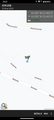
I did not have GPS tracking on, but my route was pretty much this: [1] The true distance of the trip was about 26.7 km, of which I cycled 26.6 km and walked 0.1 km.
Photos
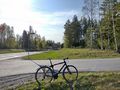
Beginning of Eeralantie road.
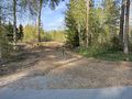
This is where I had to leave the bicycle and continue on foot, about 50 metres to go.
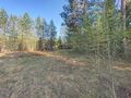
How the former field looked like. The hashpoint was pretty much in the centre of the picture.
Proof of location #1

Proof of location #2
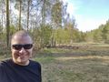
Selfie at the hashpoint.
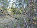
Sure signs of the upcoming summer: birches and rowans are growing new leaves...
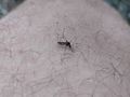
...and mosquitoes begin to eat you alive.


Achievements
Kripakko earned the Land geohash achievement
|
Kripakko earned the Bicycle geohash achievement
|