Difference between revisions of "2023-05-27 65 27"
(Created page with "{{subst:expedition}}") |
m (subst-ing) |
||
| (10 intermediate revisions by 3 users not shown) | |||
| Line 1: | Line 1: | ||
| − | + | {{meetup graticule | |
| + | | lat=65 | ||
| + | | lon=27 | ||
| + | | date=2023-05-27 | ||
| + | }} | ||
| + | == Location == | ||
| + | On Luokanvaara hill in Syöte national park. | ||
| − | + | The point on a topographic map: | |
| + | {{MapSiteLink | ||
| + | | lat = 65.6601464 | lon = 27.8445193 | ||
| + | | title = Geohash+2023-05-27+65+27 | ||
| + | }} | ||
| − | + | == Participants == | |
| − | + | * [[User:Kripakko|Kripakko]] | |
| − | + | == Expedition == | |
| − | + | After missing all previous Geohashing Days and Mouse Over Days due to unlucky locations or circumstances, this year I got a bit more lucky. At first, none of the points in nearby graticules looked too good. Given a chance, I would prefer points in virgin graticules. I gave some thought for [https://geohashing.info/2023-05-27/s/z:8/66,23 66,23] which looked interesting but not really accessible, but then I realised there was an accessible point here in 65,27. If I brought a bicycle in a bus, I would have a doable distance to cycle and plenty of time. Depending on where I would get off the outgoing morning bus and get on the returning evening bus, I would have 6–7 hours to cycle 50–65 kilometres. | |
| − | + | ||
| − | + | I decided to leave from home at 8:00, cycle to the bus station, take the bus leaving from Oulu at 8:30 and get off at the bus stop of Syöte junction at about 10:15. I would then cycle via the hashpoint to Taivalkoski where the returning bus would stop at 17:05 and arrive back in Oulu at 19:20. The weather was partly cloudy with the temperature around 10 °C – a surprisingly annoying temperature because if I wore only a t-shirt, I would get cold due to wind, and if I covered myself any more, I would get too hot due to body heat. I ended up wearing, in addition to light sweatsuit trousers and shoes, only a t-shirt most of the time and just ignoring the slight cold. Occasional sunshine and long uphills got me warmer from time to time. | |
| − | |||
| − | |||
| − | |||
| − | |||
| − | |||
| − | |||
| − | |||
| − | |||
| − | + | After getting off the bus as planned, I made my way to the hashpoint via Salmiperä, Iso-Syöte and Syötekylä. The road was very hilly, similar to what I am used to in North Karelia, but here the hills are much larger. I visited a few geocaches, shops in Iso-Syöte and Syötekylä, and Vattukuru, a beautiful rocky ravine in the national park. Since I had plenty of time to spare, I could take my time stopping in interesting locations. Finally, I parked the bicycle by the road and walked the last 300 metres. The forest was easy to traverse, and a strip of forested bog was almost completely dry except in a few narrow ditches. I reached the hashpoint at 15:00 and had two hours to walk back and cycle 25 kilometres to Taivalkoski. No big deal – I could still stop to find a few geocaches and to take some photos. I arrived at Taivalkoski bus stop at 16:55, ten minutes before the bus would arrive. After the bus ride back to Oulu, I quickly visited a store in Raksila and cycled back home, where I arrived at 19:40. | |
| − | |||
| − | + | I forgot to take distance readings from the GPS receiver, but I believe I cycled about 75 km and walked about 1 km in total. I could get more accurate values by analysing the tracklog, but I do not care enough to do it. I had to pay 65.60 EUR for bus tickets including 14.00 EUR for bringing the bicycle. | |
| − | |||
== Tracklog == | == Tracklog == | ||
| − | + | {{tracklog | 2023-05-27_65_27_tracklog.gpx}} | |
== Photos == | == Photos == | ||
| − | < | + | <gallery perrow="9"> |
| − | Image: | + | Image:2023-05-27_65_27_01-bus1.jpg | At Oulu bus station in the morning, the bus is leaving soon. |
| − | -- | + | Image:2023-05-27_65_27_02-river.jpg | The Naamanganjoki river. |
| − | + | Image:2023-05-27_65_27_03-road.jpg | Regional road 858 near Rengasvaara. Save for occasional nice views, the landscape was mostly this for the whole trip. | |
| + | Image:2023-05-27_65_27_04-reindeer1.jpg | A lone reindeer on the road. | ||
| + | Image:2023-05-27_65_27_05-ridge.jpg | On a tiny ridge by Naamankajärvi lake where I found a geocache. | ||
| + | Image:2023-05-27_65_27_06-pikkusyöte.jpg | View towards Pikku-Syöte fell. | ||
| + | Image:2023-05-27_65_27_07-isosyöte.jpg | View towards Iso-Syöte fell. | ||
| + | Image:2023-05-27_65_27_08-reindeer2.jpg | Two more reindeer that I saw. | ||
| + | Image:2023-05-27_65_27_09-vattukuru.jpg | Boulders and woods in Vattukuru. Not all snow has yet melted. | ||
| + | Image:2023-05-27_65_27_10-bogview.jpg | View to Lakisuo bog. | ||
| + | Image:2023-05-27_65_27_11-bicycle.jpg | Where I parked the bicycle, about 300 metres to go. | ||
| + | Image:2023-05-27_65_27_12-hashpoint.jpg | The hashpoint was located pretty much under the birch. | ||
| + | Image:2023-05-27_65_27_13-gpsr1.jpg | Proof of location. | ||
| + | Image:2023-05-27_65_27_14-gpsr2.jpg | Proof of date and time. | ||
| + | Image:2023-05-27_65_27_15-selfie.jpg | Stupid Grin™ at the hashpoint. | ||
| + | Image:2023-05-27_65_27_16-lakeview.jpg | View to Luokanjärvi lake and some distant hills. | ||
| + | Image:2023-05-27_65_27_17-taivalkoski.jpg | At Taivalkoski bus stop, waiting for the returning bus. | ||
| + | Image:2023-05-27_65_27_18-bus2.jpg | Back in Oulu. | ||
</gallery> | </gallery> | ||
== Achievements == | == Achievements == | ||
| − | {{ | + | {{land geohash |
| − | + | | name = [[User:Kripakko|Kripakko]] | |
| + | | latitude = 65 | longitude = 27 | date = 2023-05-27 | ||
| + | }} | ||
| + | {{public transport geohash | ||
| + | | name = [[User:Kripakko|Kripakko]] | ||
| + | | busline = the Oulu–Kuusamo bus line | ||
| + | | latitude = 65 | longitude = 27 | date = 2023-05-27 | ||
| + | }} | ||
| + | {{Geohashing Day | ||
| + | | name = [[User:Kripakko|Kripakko]] | ||
| + | | mouseover = true | ||
| + | | year = 2023 | ||
| + | | latitude = 65 | longitude = 27 | coorddate = 2023-05-27 | ||
| + | }} | ||
| + | {{graticule unlocked | ||
| + | | name = [[User:Kripakko|Kripakko]] | ||
| + | | latitude = 65 | longitude = 27 | date = 2023-05-27 | ||
| + | }} | ||
__NOTOC__ | __NOTOC__ | ||
| − | |||
| − | |||
| − | |||
| − | |||
| − | |||
| − | |||
| − | |||
| − | |||
| − | |||
| − | |||
| − | |||
| − | |||
| − | |||
[[Category:Expeditions]] | [[Category:Expeditions]] | ||
| − | |||
[[Category:Expeditions with photos]] | [[Category:Expeditions with photos]] | ||
| − | |||
| − | |||
| − | |||
| − | |||
| − | |||
[[Category:Coordinates reached]] | [[Category:Coordinates reached]] | ||
| − | + | {{location|FI|14}} | |
| − | |||
| − | |||
| − | |||
| − | |||
| − | |||
| − | |||
| − | |||
| − | |||
| − | |||
| − | |||
| − | |||
| − | |||
| − | |||
| − | |||
| − | |||
| − | |||
| − | |||
Latest revision as of 21:00, 24 May 2024
| Sat 27 May 2023 in 65,27: 65.6601464, 27.8445193 geohashing.info google osm bing/os kml crox |
Location
On Luokanvaara hill in Syöte national park.
The point on a topographic map: [1]
Participants
Expedition
After missing all previous Geohashing Days and Mouse Over Days due to unlucky locations or circumstances, this year I got a bit more lucky. At first, none of the points in nearby graticules looked too good. Given a chance, I would prefer points in virgin graticules. I gave some thought for 66,23 which looked interesting but not really accessible, but then I realised there was an accessible point here in 65,27. If I brought a bicycle in a bus, I would have a doable distance to cycle and plenty of time. Depending on where I would get off the outgoing morning bus and get on the returning evening bus, I would have 6–7 hours to cycle 50–65 kilometres.
I decided to leave from home at 8:00, cycle to the bus station, take the bus leaving from Oulu at 8:30 and get off at the bus stop of Syöte junction at about 10:15. I would then cycle via the hashpoint to Taivalkoski where the returning bus would stop at 17:05 and arrive back in Oulu at 19:20. The weather was partly cloudy with the temperature around 10 °C – a surprisingly annoying temperature because if I wore only a t-shirt, I would get cold due to wind, and if I covered myself any more, I would get too hot due to body heat. I ended up wearing, in addition to light sweatsuit trousers and shoes, only a t-shirt most of the time and just ignoring the slight cold. Occasional sunshine and long uphills got me warmer from time to time.
After getting off the bus as planned, I made my way to the hashpoint via Salmiperä, Iso-Syöte and Syötekylä. The road was very hilly, similar to what I am used to in North Karelia, but here the hills are much larger. I visited a few geocaches, shops in Iso-Syöte and Syötekylä, and Vattukuru, a beautiful rocky ravine in the national park. Since I had plenty of time to spare, I could take my time stopping in interesting locations. Finally, I parked the bicycle by the road and walked the last 300 metres. The forest was easy to traverse, and a strip of forested bog was almost completely dry except in a few narrow ditches. I reached the hashpoint at 15:00 and had two hours to walk back and cycle 25 kilometres to Taivalkoski. No big deal – I could still stop to find a few geocaches and to take some photos. I arrived at Taivalkoski bus stop at 16:55, ten minutes before the bus would arrive. After the bus ride back to Oulu, I quickly visited a store in Raksila and cycled back home, where I arrived at 19:40.
I forgot to take distance readings from the GPS receiver, but I believe I cycled about 75 km and walked about 1 km in total. I could get more accurate values by analysing the tracklog, but I do not care enough to do it. I had to pay 65.60 EUR for bus tickets including 14.00 EUR for bringing the bicycle.
Tracklog
Photos
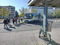
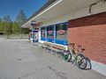
At Oulu bus station in the morning, the bus is leaving soon.
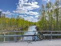
The Naamanganjoki river.
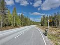
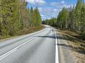
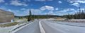
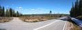
Regional road 858 near Rengasvaara. Save for occasional nice views, the landscape was mostly this for the whole trip.
A lone reindeer on the road.
On a tiny ridge by Naamankajärvi lake where I found a geocache.
View towards Pikku-Syöte fell.
View towards Iso-Syöte fell.
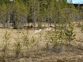
Two more reindeer that I saw.
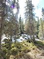
Boulders and woods in Vattukuru. Not all snow has yet melted.
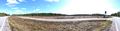
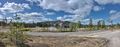
View to Lakisuo bog.
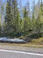
Where I parked the bicycle, about 300 metres to go.
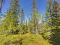
The hashpoint was located pretty much under the birch.
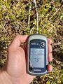
Proof of location.
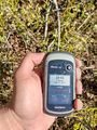
Proof of date and time.
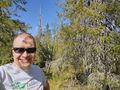
Stupid Grin™ at the hashpoint.
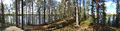
View to Luokanjärvi lake and some distant hills.
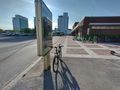
At Taivalkoski bus stop, waiting for the returning bus.
Back in Oulu.


Achievements
Kripakko earned the Land geohash achievement
|
Kripakko earned the Public transport geohash achievement
|
Kripakko earned the 2023 Mouse Over Day achievement
|
Kripakko earned the Graticule Unlocked Achievement
|