Difference between revisions of "2023-07-08 43 -79"
From Geohashing
([live picture]At the spot) |
m (Location) |
||
| (9 intermediate revisions by one other user not shown) | |||
| Line 1: | Line 1: | ||
| − | + | [[Image:{{{image|2023-07-08 43 -79 frogman 1688846842388.jpg}}}|thumb|left]] | |
| − | + | {{meetup graticule | |
| − | [[Image:{{{image| | ||
| − | |||
| − | |||
| − | |||
| − | |||
| − | |||
| − | |||
| lat=43 | | lat=43 | ||
| lon=-79 | | lon=-79 | ||
| date=2023-07-08 | | date=2023-07-08 | ||
| − | }} | + | }} |
== Location == | == Location == | ||
| − | + | At Rathburn Road and The East Mall. | |
== Participants == | == Participants == | ||
| − | + | *[[User:Frogman|Frogman]] | |
| − | |||
| − | |||
| − | |||
| − | |||
== Expedition == | == Expedition == | ||
| − | + | Not too much to say about this one. I tried to take the Rathburn bus from Royal York station, but I missed it by two minutes, so I continued on to Kipling station and caught the The East Mall bus instead. The hashpoint was at the intersection near a pharmacy. Instead of taking the bus back I walked down a ravine trail to Islington station. | |
| − | |||
| − | |||
== Photos == | == Photos == | ||
| Line 35: | Line 22: | ||
Image:2023-07-08_43_-79_frogman_1688846819985.jpg|At the spot | Image:2023-07-08_43_-79_frogman_1688846819985.jpg|At the spot | ||
| + | |||
| + | Image:2023-07-08_43_-79_frogman_1688846842388.jpg|North | ||
| + | |||
| + | Image:2023-07-08_43_-79_frogman_1688846852617.jpg|West | ||
| + | |||
| + | Image:2023-07-08_43_-79_frogman_1688846863708.jpg|South | ||
| + | |||
| + | Image:2023-07-08_43_-79_frogman_1688846870393.jpg|Me | ||
| + | |||
| + | Image:2023-07-08_43_-79_frogman_1688846887491.jpg|Hampshire Heights Park | ||
| + | |||
| + | Image:2023-07-08_43_-79_frogman_1688846909798.jpg|Mimico Creek | ||
| + | |||
| + | Image:2023-07-08_43_-79_frogman_1688846915888.jpg|Art | ||
| + | |||
| + | Image:2023-07-08_43_-79_frogman_1688846924448.jpg|Duck | ||
</gallery> | </gallery> | ||
== Achievements == | == Achievements == | ||
{{#vardefine:ribbonwidth|100%}} | {{#vardefine:ribbonwidth|100%}} | ||
| − | + | {{Public transport geohash | |
| − | + | | latitude = 43 | |
| − | + | | longitude = -79 | |
| − | + | | date = 2023-07-08 | |
| − | [[ | + | | busline = the TTC |
| + | | name = [[User:Frogman|Frogman]] | ||
| − | + | }} | |
| − | + | __NOTOC__ | |
| − | |||
| − | |||
| − | |||
| − | |||
| − | |||
| − | |||
| − | |||
[[Category:Expeditions]] | [[Category:Expeditions]] | ||
| − | |||
[[Category:Expeditions with photos]] | [[Category:Expeditions with photos]] | ||
| − | |||
| − | |||
| − | |||
| − | |||
| − | |||
[[Category:Coordinates reached]] | [[Category:Coordinates reached]] | ||
| − | + | {{location|CA|ON|TO}} | |
| − | |||
| − | |||
| − | |||
| − | |||
| − | |||
| − | |||
| − | |||
| − | |||
| − | |||
| − | |||
| − | |||
| − | |||
| − | |||
| − | |||
| − | |||
| − | |||
| − | |||
Latest revision as of 20:42, 8 July 2023
| Sat 8 Jul 2023 in 43,-79: 43.6550501, -79.5646163 geohashing.info google osm bing/os kml crox |
Location
At Rathburn Road and The East Mall.
Participants
Expedition
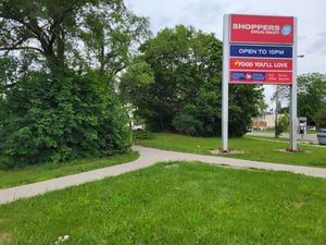
Not too much to say about this one. I tried to take the Rathburn bus from Royal York station, but I missed it by two minutes, so I continued on to Kipling station and caught the The East Mall bus instead. The hashpoint was at the intersection near a pharmacy. Instead of taking the bus back I walked down a ravine trail to Islington station.
Photos
Achievements
Frogman earned the Public transport geohash achievement
|


