Difference between revisions of "2023-08-06 59 5"
From Geohashing
(→Photos) |
(→Tracklog) |
||
| (8 intermediate revisions by the same user not shown) | |||
| Line 12: | Line 12: | ||
| date=2023-08-06 | | date=2023-08-06 | ||
}}<!-- edit as necessary --> | }}<!-- edit as necessary --> | ||
| + | [[Image:1691324811879 58 5 Me.jpg|thumb|left]] | ||
== Location == | == Location == | ||
<!-- where you've surveyed the hash to be --> | <!-- where you've surveyed the hash to be --> | ||
| Line 31: | Line 32: | ||
== Tracklog == | == Tracklog == | ||
<!-- if your GPS device keeps a log, you may use Template:Tracklog, post a link here, or both --> | <!-- if your GPS device keeps a log, you may use Template:Tracklog, post a link here, or both --> | ||
| + | |||
| + | {{tracklog |activity 11724967957.gpx}} | ||
== Photos == | == Photos == | ||
| Line 41: | Line 44: | ||
Image:1691325068231 58 5 1x.jpg|thumb|On the way to the hash, we saw the car ferry Mortavika - Arsvågen. | Image:1691325068231 58 5 1x.jpg|thumb|On the way to the hash, we saw the car ferry Mortavika - Arsvågen. | ||
Image:1691325108781 58 5 2.jpg|thumb|On the way to the hash we saw some sheep | Image:1691325108781 58 5 2.jpg|thumb|On the way to the hash we saw some sheep | ||
| − | + | Image:1691325170580 58 5 3.jpg|thumb|On the way to the hash we saw some sheep | |
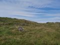
| − | + | Image:1691324856653 58 5 N.jpg|thumb|View to the north | |
| − | + | Image:1691324896416 58 5 V.jpg|thumb|View to the west | |
| + | Image:1691324936806 58 5 SE.jpg|thumb|View to the southeast | ||
</gallery> | </gallery> | ||
| Line 50: | Line 54: | ||
<!-- Add any achievement ribbons you earned below, or remove this section --> | <!-- Add any achievement ribbons you earned below, or remove this section --> | ||
| − | + | {{land geohash |name=[[User:Pica42|Pica42]] |date=2023-08-06 |latitude=59 |longitude=5 }} | |
| − | |||
| − | |||
| − | [[ | ||
| − | |||
| − | |||
| − | |||
| − | |||
| − | |||
| − | |||
| − | |||
| − | |||
| − | |||
| − | |||
| − | |||
[[Category:Expeditions]] | [[Category:Expeditions]] | ||
| − | |||
[[Category:Expeditions with photos]] | [[Category:Expeditions with photos]] | ||
| − | |||
| − | |||
| − | |||
| − | |||
| − | |||
[[Category:Coordinates reached]] | [[Category:Coordinates reached]] | ||
| + | {{location|NO|11}} | ||
| − | + | __NOTOC__ | |
| − | |||
| − | |||
| − | |||
| − | |||
| − | |||
| − | |||
| − | |||
| − | |||
| − | |||
| − | |||
| − | |||
| − | |||
| − | |||
| − | |||
| − | |||
| − | |||
Latest revision as of 13:47, 6 August 2023
| Sun 6 Aug 2023 in 59,5: 59.1262820, 5.5832361 geohashing.info google osm bing/os kml crox |

Location
On the small peninsula Reianes, Rennesøy, Stavanger, Norway
Participants
Plans
Expedition
Tracklog
Photos

Reianes @59.1263,5.5832
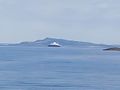
On the way to the hash, we saw the car ferry Mortavika - Arsvågen.
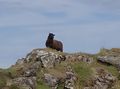
On the way to the hash we saw some sheep
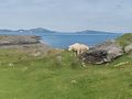
On the way to the hash we saw some sheep

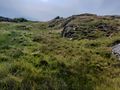
View to the north
View to the west
View to the southeast


Achievements
Pica42 earned the Land geohash achievement
|