Difference between revisions of "2023-08-10 58 5"
From Geohashing
([live picture]Årsland [https://openstreetmap.org/?mlat=58.59236970&mlon=5.64694110&zoom=16 @58.5924,5.6469]) |
(→Expedition) |
||
| (9 intermediate revisions by the same user not shown) | |||
| Line 12: | Line 12: | ||
| date=2023-08-10 | | date=2023-08-10 | ||
}}<!-- edit as necessary --> | }}<!-- edit as necessary --> | ||
| + | [[Image:20230810 58 5 Me.jpg|thumb|left]] | ||
== Location == | == Location == | ||
<!-- where you've surveyed the hash to be --> | <!-- where you've surveyed the hash to be --> | ||
| + | |||
| + | A few meters from a tractor road on a farm in Årsland, Vigrestad, Hå municipality, Norway. | ||
== Participants == | == Participants == | ||
<!-- who attended: If you link to your wiki user name in this section, your expedition will be picked up by the various statistics generated for geohashing. You may use three tildes ~ as a shortcut to automatically insert the user signature of the account you are editing with. | <!-- who attended: If you link to your wiki user name in this section, your expedition will be picked up by the various statistics generated for geohashing. You may use three tildes ~ as a shortcut to automatically insert the user signature of the account you are editing with. | ||
--> | --> | ||
| + | |||
| + | *[[User:Pica42|Pica42]] | ||
== Plans == | == Plans == | ||
| Line 24: | Line 29: | ||
== Expedition == | == Expedition == | ||
<!-- how it all turned out. your narrative goes here. --> | <!-- how it all turned out. your narrative goes here. --> | ||
| + | |||
| + | Today's trip started with about 25 km by car, then it was only almost 1 km to walk to the hash. The weather was fine but not that hot. Everything went as planned. | ||
== Tracklog == | == Tracklog == | ||
| Line 35: | Line 42: | ||
Image:2023-08-10_58_5_Pica42_1691659639259.jpg|Årsland [https://openstreetmap.org/?mlat=58.59236970&mlon=5.64694110&zoom=16 @58.5924,5.6469] | Image:2023-08-10_58_5_Pica42_1691659639259.jpg|Årsland [https://openstreetmap.org/?mlat=58.59236970&mlon=5.64694110&zoom=16 @58.5924,5.6469] | ||
| + | Image:20230810 58 5 W.jpg|thumb|View from the hash to the west | ||
| + | Image:20230810 58 5 S.jpg|thumb|View from the hash to the south | ||
| + | Image:20230810 58 5 E.jpg|thumb|View from the hash to the east | ||
| + | Image:20230810 58 5 N.jpg|thumb|View from the hash to the north | ||
| + | |||
</gallery> | </gallery> | ||
| Line 41: | Line 53: | ||
<!-- Add any achievement ribbons you earned below, or remove this section --> | <!-- Add any achievement ribbons you earned below, or remove this section --> | ||
| − | + | {{land geohash |name=[[User:Pica42|Pica42]] |date=2023-08-10 |latitude=58 |longitude=5 }} | |
| − | |||
| − | |||
| − | [[ | ||
| − | |||
| − | |||
| − | |||
| − | |||
| − | |||
| − | |||
| − | |||
| − | |||
| − | |||
| − | |||
| − | |||
[[Category:Expeditions]] | [[Category:Expeditions]] | ||
| − | |||
[[Category:Expeditions with photos]] | [[Category:Expeditions with photos]] | ||
| − | |||
| − | |||
| − | |||
| − | |||
| − | |||
[[Category:Coordinates reached]] | [[Category:Coordinates reached]] | ||
| + | {{location|NO|11}} | ||
| − | + | __NOTOC__ | |
| − | |||
| − | |||
| − | |||
| − | |||
| − | |||
| − | |||
| − | |||
| − | |||
| − | |||
| − | |||
| − | |||
| − | |||
| − | |||
| − | |||
| − | |||
| − | |||
Latest revision as of 13:06, 10 August 2023
| Thu 10 Aug 2023 in 58,5: 58.5923109, 5.6470764 geohashing.info google osm bing/os kml crox |

Location
A few meters from a tractor road on a farm in Årsland, Vigrestad, Hå municipality, Norway.
Participants
Plans
Expedition
Today's trip started with about 25 km by car, then it was only almost 1 km to walk to the hash. The weather was fine but not that hot. Everything went as planned.
Tracklog
Photos

Årsland @58.5924,5.6469
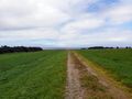
View from the hash to the west
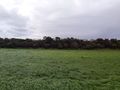
View from the hash to the south
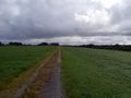
View from the hash to the east
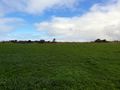
View from the hash to the north


Achievements
Pica42 earned the Land geohash achievement
|