Difference between revisions of "2023-08-18 49 11"
From Geohashing
(→Photos: fix links) |
m (subst-ing) |
||
| (6 intermediate revisions by 2 users not shown) | |||
| Line 8: | Line 8: | ||
And DON'T FORGET to add your expedition and the best photo you took to the gallery on the Main Page! We'd love to read your report, but that means we first have to discover it! :) | And DON'T FORGET to add your expedition and the best photo you took to the gallery on the Main Page! We'd love to read your report, but that means we first have to discover it! :) | ||
-->{{meetup graticule | -->{{meetup graticule | ||
| − | | lat= | + | | lat=49 |
| − | | lon= | + | | lon=11 |
| − | | date= | + | | date=2023-08-18 |
}}<!-- edit as necessary --> | }}<!-- edit as necessary --> | ||
__NOTOC__ | __NOTOC__ | ||
| Line 17: | Line 17: | ||
== Participants == | == Participants == | ||
| − | [[User:Sp3pbn|Sp3pbn]] ([[User talk:Sp3pbn|talk]]) | + | *[[User:Sp3pbn|Sp3pbn]] ([[User talk:Sp3pbn|talk]]) |
| + | *[[User:Torodeas|Torodeas]] ([[User talk:Torodeas|talk]]) | ||
== Plans == | == Plans == | ||
| + | *[[User:Sp3pbn|Sp3pbn]] | ||
As I missed the (nearly) couch-potato hash two days ago (was ~300m from my home, but in a fenced off area), today is another one only 1.5 km (flight distance) away. | As I missed the (nearly) couch-potato hash two days ago (was ~300m from my home, but in a fenced off area), today is another one only 1.5 km (flight distance) away. | ||
It's over the hill, so the real distance is longer. But it should be easily manageable for me to get both ways by bike in half an hour. | It's over the hill, so the real distance is longer. But it should be easily manageable for me to get both ways by bike in half an hour. | ||
| + | |||
| + | *[[User:Torodeas|Torodeas]] | ||
| + | No real plans for me: I just liked the weather for a hike, looked where the hash was and decided I can easily reach it from a bus stop | ||
== Expedition == | == Expedition == | ||
Quick bike ride there. Hash is near a feeding area for deer, nothing of note happend (except for the near 30°C heat, luckily the ride was mostly through the forest). | Quick bike ride there. Hash is near a feeding area for deer, nothing of note happend (except for the near 30°C heat, luckily the ride was mostly through the forest). | ||
| + | |||
| + | |||
| + | == Torodeas' Tracklog == | ||
| + | {{tracklog|Torodeas_20230818.gpx}} | ||
| + | |||
== Photos == | == Photos == | ||
<gallery perrow="5"> | <gallery perrow="5"> | ||
| − | Image: | + | Image:20230818 track.jpg | Track through the forest |
| − | Image: | + | Image:20230818 hash area.jpg | Surroundings of the hash |
| − | Image: | + | Image:20230818 bike.jpg | Proof that I took my bike |
| − | Image: | + | Image:20230818 hash proof.png | Close enough |
</gallery> | </gallery> | ||
Latest revision as of 21:04, 24 May 2024
| Fri 18 Aug 2023 in 49,11: 49.6487212, 11.1886265 geohashing.info google osm bing/os kml crox |
Location
In the forest near Ermreuth
Participants
Plans
As I missed the (nearly) couch-potato hash two days ago (was ~300m from my home, but in a fenced off area), today is another one only 1.5 km (flight distance) away. It's over the hill, so the real distance is longer. But it should be easily manageable for me to get both ways by bike in half an hour.
No real plans for me: I just liked the weather for a hike, looked where the hash was and decided I can easily reach it from a bus stop
Expedition
Quick bike ride there. Hash is near a feeding area for deer, nothing of note happend (except for the near 30°C heat, luckily the ride was mostly through the forest).
Torodeas' Tracklog
Photos
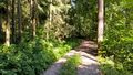
Track through the forest
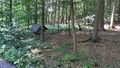
Surroundings of the hash
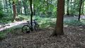
Proof that I took my bike
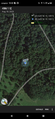
Close enough


