Difference between revisions of "2023-09-06 31 35"
Yerushalmi (talk | contribs) (Created page with "{{subst:Expedition2}}") |
m (subst-ing) |
||
| (5 intermediate revisions by 2 users not shown) | |||
| Line 1: | Line 1: | ||
| + | <!-- If you did not specify these parameters in the template, please substitute appropriate values for IMAGE, LAT, LON, and DATE (YYYY-MM-DD format) | ||
| − | + | [[Image:{{{image|IMAGE}}}|thumb|left]] | |
| − | + | Remove this section if you don't want an image at the top (left) of your report. You should remove the "Image:" or "File:" | |
| + | tag from your image file name, and replace the all upper-case word IMAGE in the above line. | ||
| − | --> | + | And DON'T FORGET to add your expedition and the best photo you took to the gallery on the Main Page! We'd love to read your report, but that means we first have to discover it! :) |
| − | {{meetup graticule | + | -->{{meetup graticule |
| − | | lat= | + | | lat=31 |
| − | | lon= | + | | lon=35 |
| − | | date= | + | | date=2023-09-06 |
| − | }} | + | }}<!-- edit as necessary --> |
== Location == | == Location == | ||
| − | + | In Rabin Park, near a quarry outside of Beit Meir | |
== Participants == | == Participants == | ||
| − | + | [[User:Yerushalmi|Yerushalmi]] ([[User talk:Yerushalmi|talk]]) | |
| − | |||
| − | |||
== Plans == | == Plans == | ||
| + | At some convenient point today I'll take a bus to the general area, walk to the point, then walk back to the bus station and bus to Jerusalem. | ||
| + | |||
| + | == Expedition == | ||
| + | I took the 615/617 from Jerusalem to the bus stop on route 38, crossed 38 on a pedestrian footbridge, and walked into the forest. Using Geohash Droid as my map, I had no trouble navigating which paths I needed to take. | ||
| + | |||
| + | The hashpoint was inside the "elbow" of a path that went from west to east and then hooked to the north. I had to decide whether to go north from the west-east part or go west from the south-north part. | ||
| + | |||
| + | [[File:Screenshot_20230907_155347_Geohash Droid.jpg|400px]] | ||
| + | |||
| + | Heading north from the west-east part looked too steep to attempt safely: | ||
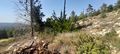
| + | |||
| + | [[File:20230906_153645.jpg|400px]] | ||
| + | So I headed past to the elbow and turned north, saying hi as I passed some loggers who were working there. The descent into the valley from the east was far easier: | ||
| − | + | [[File:20230906_150854.jpg|400px]] | |
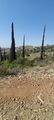
| + | |||
| + | I got nervous as I approached the point that it might be in the middle of this impassible clump of trees: | ||
| + | |||
| + | [[File:20230906_151855.jpg|400px]] | ||
| + | But it turned out to be a few meters away. | ||
| + | Walked back the way I came, took the bus back to Jerusalem. Bosh. | ||
== Photos == | == Photos == | ||
| − | < | + | <gallery> |
| − | + | File:20230906_141435.jpg | Sign at the entrance to the forest | |
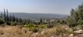
| − | + | File:20230906_145417.jpg | It would be a nice view if not for the permanent cloud of dust | |
| − | + | File:20230906_145433.jpg | I can probably get down here | |
| − | + | File:20230906_145538.jpg | |
| + | File:20230906_150617.jpg | ||
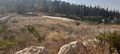
| + | File:20230906_150854.jpg | In the valley | ||
| + | File:20230906_150900.jpg | ||
| + | File:20230906_151823.jpg | Panorama at the point | ||
| + | File:20230906_151855.jpg | ||
| + | File:20230906_153340.jpg | I'm glad I didn't try to go down this way | ||
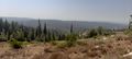
| + | File:20230906_153645.jpg | A quarry off in the distance | ||
| + | File:20230906_153651.jpg | ||
| + | File:20230906_161318.jpg | A footbridge over route 38 with a "Warning: Danger of falling" sign (not the bridge I used, of course) | ||
| + | File:Screenshot_20230906_151806_Geohash Droid.jpg | Proof | ||
| + | File:Screenshot_20230907_155347_Geohash Droid.jpg | The point relative to the two paths. I came in from the west, turned north at the fork, and approached the point from the east | ||
</gallery> | </gallery> | ||
| − | |||
| − | |||
| − | |||
__NOTOC__ | __NOTOC__ | ||
| − | |||
| − | |||
| − | |||
| − | |||
[[Category:Expeditions]] | [[Category:Expeditions]] | ||
[[Category:Expeditions with photos]] | [[Category:Expeditions with photos]] | ||
| − | |||
[[Category:Coordinates reached]] | [[Category:Coordinates reached]] | ||
| − | + | {{location|IL|JM}} | |
| − | |||
| − | |||
| − | |||
| − | |||
| − | |||
| − | |||
| − | |||
Latest revision as of 21:05, 24 May 2024
| Wed 6 Sep 2023 in 31,35: 31.7917828, 35.0259824 geohashing.info google osm bing/os kml crox |
Location
In Rabin Park, near a quarry outside of Beit Meir
Participants
Plans
At some convenient point today I'll take a bus to the general area, walk to the point, then walk back to the bus station and bus to Jerusalem.
Expedition
I took the 615/617 from Jerusalem to the bus stop on route 38, crossed 38 on a pedestrian footbridge, and walked into the forest. Using Geohash Droid as my map, I had no trouble navigating which paths I needed to take.
The hashpoint was inside the "elbow" of a path that went from west to east and then hooked to the north. I had to decide whether to go north from the west-east part or go west from the south-north part.

Heading north from the west-east part looked too steep to attempt safely:

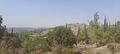
So I headed past to the elbow and turned north, saying hi as I passed some loggers who were working there. The descent into the valley from the east was far easier:

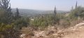
I got nervous as I approached the point that it might be in the middle of this impassible clump of trees:

But it turned out to be a few meters away.
Walked back the way I came, took the bus back to Jerusalem. Bosh.
Photos
Sign at the entrance to the forest
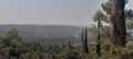
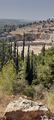
It would be a nice view if not for the permanent cloud of dust
I can probably get down here
In the valley
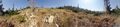
Panorama at the point
I'm glad I didn't try to go down this way
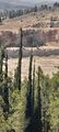
A quarry off in the distance
A footbridge over route 38 with a "Warning: Danger of falling" sign (not the bridge I used, of course)
Proof
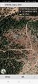
The point relative to the two paths. I came in from the west, turned north at the fork, and approached the point from the east


