Difference between revisions of "2023-10-14 -37 144"
From Geohashing
Felix Dance (talk | contribs) (Added expedition description) |
m (Location) |
||
| (One intermediate revision by one other user not shown) | |||
| Line 25: | Line 25: | ||
{{bicycle geohash | {{bicycle geohash | ||
| − | | latitude = | + | | latitude = -37 |
| − | | longitude = | + | | longitude = 144 |
| date = 2023-10-14 | | date = 2023-10-14 | ||
| name = [[User:Johnwrw|John]] | | name = [[User:Johnwrw|John]] | ||
| Line 35: | Line 35: | ||
}} | }} | ||
| − | |||
[[Category:Expeditions]] | [[Category:Expeditions]] | ||
[[Category:Expeditions with photos]] | [[Category:Expeditions with photos]] | ||
[[Category:Coordinates reached]] | [[Category:Coordinates reached]] | ||
| + | {{location|AU|VIC|HU}} | ||
Latest revision as of 05:42, 26 October 2023

| Sat 14 Oct 2023 in -37,144: -37.5873906, 144.9453599 geohashing.info google osm bing/os kml crox |
Location
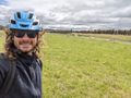
On the Galada Tamboore Pathway, Craigieburn.
Participants
Expedition
Almost no details on this hash. John announced he was embarking on the expedition at 10:08am, arrived at 11:57am as confirmed by his photo to the group, and no more information was forthcoming.
Photos
Success
Achievements
John earned the Bicycle geohash achievement
|