Difference between revisions of "2023-11-13 41 12"
m (Location) |
m (subst-ing) |
||
| (11 intermediate revisions by 2 users not shown) | |||
| Line 1: | Line 1: | ||
| + | {{meetup graticule|date=2023-11-13|lat=41|lon=12}} | ||
| + | ==Location== | ||
| + | This Geohash is located next to the ''Via Fiume Azzurro'' in Torrino. | ||
| + | |||
| + | ==Participants== | ||
| + | *[[User:Jezza|Jezza]] ([[User talk:Jezza|talk]]) | ||
| + | |||
| + | ==Plans== | ||
Setting off now on my bike. May be there in 45 minutes. | Setting off now on my bike. May be there in 45 minutes. | ||
| + | |||
| + | == Expedition == | ||
| + | <!-- how it all turned out. your narrative goes here. --> | ||
| + | Too good to be true. Another geohash within cycling distance, this time on the old road bike. The location is actually quite close to the end of one of my usual rides, but on the other side of a lethal road and the railroad tracks. In the end, I worked out a way to get there without obvious risk, along a big road that had a cycle path. There was a very steep climb near the end, from the top of which I took a photo of the sewage farm that I normally pass on the other side. Too exhilarated by making it up that climb, I overshot the mark on the way down, but managed to retrace my steps. | ||
| + | |||
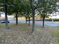
| + | The geohash was on a patch of green among some trees, and I got as close as I could by repeatedly reloading geohashing.info, at the same time recognising that the phone location would never be 100% reliable. | ||
| + | |||
| + | Excellent expedition of about 24 km in glorious sunshine. | ||
| + | |||
| + | == Photos == | ||
| + | <!-- Insert pictures between the gallery tags using the following format: | ||
| + | Image:2020-##-## ## ## Alpha.jpg | Witty Comment | ||
| + | --> | ||
| + | <gallery perrow="5"> | ||
| + | File:2023-11-13 41 12 railway-bridge.jpg|thumb|Tricky railway bridge | ||
| + | File:2023-11-13 41 12 sewage-farm.jpg|thumb|Sewage farm | ||
| + | File:2023-11-13 41 12 map.jpg|thumb|I reckon this counts as reaching the geohash | ||
| + | File:2023-11-13 41 12 on the spot.jpg|thumb|On the spot | ||
| + | File:2023-11-13 41 12 looking-north.jpg|thumb|Looking north | ||
| + | File:2023-11-13 41 12 looking-south.jpg|thumb|Looking south | ||
| + | File:2023-11-13 41 12 bicycle.jpg|thumb|Trusty Raleigh (1979 Record) | ||
| + | File:2023-11-13 41 12 track.jpg|thumb|Route | ||
| + | </gallery> | ||
| + | |||
| + | == Achievements == | ||
| + | {{#vardefine:ribbonwidth|100%}} | ||
| + | <!-- Add any achievement ribbons you earned below, or remove this section --> | ||
| + | |||
| + | __NOTOC__ | ||
| + | {{bicycle geohash | ||
| + | | latitude=41 | ||
| + | | longitude=12 | ||
| + | | date=2023-11-13 | ||
| + | | distance=23.1km | ||
| + | | bothways=true | ||
| + | }} | ||
| + | |||
| + | [[Category:Expeditions]] | ||
| + | [[Category:Expeditions with photos]] | ||
| + | [[Category:Coordinates reached]] | ||
{{location|IT|LZ}} | {{location|IT|LZ}} | ||
Latest revision as of 21:09, 24 May 2024
| Mon 13 Nov 2023 in 41,12: 41.8112018, 12.4317168 geohashing.info google osm bing/os kml crox |
Location
This Geohash is located next to the Via Fiume Azzurro in Torrino.
Participants
Plans
Setting off now on my bike. May be there in 45 minutes.
Expedition
Too good to be true. Another geohash within cycling distance, this time on the old road bike. The location is actually quite close to the end of one of my usual rides, but on the other side of a lethal road and the railroad tracks. In the end, I worked out a way to get there without obvious risk, along a big road that had a cycle path. There was a very steep climb near the end, from the top of which I took a photo of the sewage farm that I normally pass on the other side. Too exhilarated by making it up that climb, I overshot the mark on the way down, but managed to retrace my steps.
The geohash was on a patch of green among some trees, and I got as close as I could by repeatedly reloading geohashing.info, at the same time recognising that the phone location would never be 100% reliable.
Excellent expedition of about 24 km in glorious sunshine.
Photos
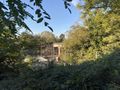
Tricky railway bridge
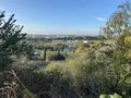
Sewage farm
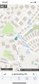
I reckon this counts as reaching the geohash
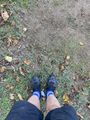
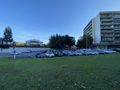
On the spot
Looking north
Looking south
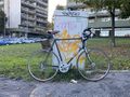
Trusty Raleigh (1979 Record)
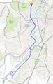
Route


Achievements
This user earned the Bicycle geohash achievement
|