Difference between revisions of "2023-11-23 58 5"
From Geohashing
(→Participants) |
(→Expedition) |
||
| (13 intermediate revisions by the same user not shown) | |||
| Line 12: | Line 12: | ||
| date=2023-11-23 | | date=2023-11-23 | ||
}}<!-- edit as necessary --> | }}<!-- edit as necessary --> | ||
| + | [[Image:20231123 58 5 Me.jpg|thumb|left]] | ||
== Location == | == Location == | ||
<!-- where you've surveyed the hash to be --> | <!-- where you've surveyed the hash to be --> | ||
| Line 28: | Line 29: | ||
== Expedition == | == Expedition == | ||
<!-- how it all turned out. your narrative goes here. --> | <!-- how it all turned out. your narrative goes here. --> | ||
| + | |||
| + | Today the weather was a bit bad, about 7 ℃ and a gale from the west. The hash was in cultivated land near a road. It was quite wet with tractor tracks with some water. Because of the weather, it wasn't so nice to walk around to find the exact hash point. | ||
== Tracklog == | == Tracklog == | ||
| Line 37: | Line 40: | ||
--> | --> | ||
<gallery perrow="5"> | <gallery perrow="5"> | ||
| + | Image:2023-11-23_58_5_Pica42_1700735674619.jpg|Tu [https://openstreetmap.org/?mlat=58.74990160&mlon=5.64857100&zoom=16 @58.7499,5.6486] | ||
| + | Image:20231123 58 5 S.jpg|thumb|View to the south | ||
| + | Image:20231123 58 5 E.jpg|thumb|View to the east | ||
| + | Image:20231123 58 5 N.jpg|thumb|View to the north | ||
| + | Image:20231123 58 5 W.jpg|thumb|View to the west | ||
| + | |||
</gallery> | </gallery> | ||
| Line 43: | Line 52: | ||
<!-- Add any achievement ribbons you earned below, or remove this section --> | <!-- Add any achievement ribbons you earned below, or remove this section --> | ||
| − | + | {{land geohash |name=[[User:Pica42|Pica42]] |date=2023-11-23 |latitude=58 |longitude=5 }} | |
| − | |||
| − | |||
| − | [[ | ||
| − | |||
| − | |||
| − | |||
| − | |||
| − | |||
| − | |||
| − | |||
| − | |||
| − | |||
| − | |||
| − | |||
[[Category:Expeditions]] | [[Category:Expeditions]] | ||
| − | |||
[[Category:Expeditions with photos]] | [[Category:Expeditions with photos]] | ||
| − | |||
| − | |||
| − | |||
| − | |||
| − | |||
[[Category:Coordinates reached]] | [[Category:Coordinates reached]] | ||
| + | {{location|NO|11}} | ||
| − | + | __NOTOC__ | |
| − | |||
| − | |||
| − | |||
| − | |||
| − | |||
| − | |||
| − | |||
| − | |||
| − | |||
| − | |||
| − | |||
| − | |||
| − | |||
| − | |||
| − | |||
| − | |||
Latest revision as of 11:34, 23 November 2023
| Thu 23 Nov 2023 in 58,5: 58.7499223, 5.6485165 geohashing.info google osm bing/os kml crox |
Location
On cultivated land at Tu, Klepp, Norway
Participants
Plans
Expedition
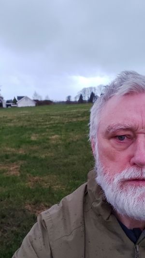
Today the weather was a bit bad, about 7 ℃ and a gale from the west. The hash was in cultivated land near a road. It was quite wet with tractor tracks with some water. Because of the weather, it wasn't so nice to walk around to find the exact hash point.
Tracklog
Photos
Achievements
Pica42 earned the Land geohash achievement
|


