Difference between revisions of "2023-10-15 52 5"
From Geohashing
m (subst-ing) |
|||
| (4 intermediate revisions by 2 users not shown) | |||
| Line 1: | Line 1: | ||
| + | [[Image:{{{image|2023-10-15_52_5_4_Nice_area.jpeg}}}|thumb|left]] | ||
{{meetup graticule | {{meetup graticule | ||
| − | | lat= | + | | lat=52 |
| − | | lon= | + | | lon=5 |
| − | | date= | + | | date=2023-10-15 |
}}<!-- edit as necessary --> | }}<!-- edit as necessary --> | ||
== Location == | == Location == | ||
| Line 8: | Line 9: | ||
== Participants == | == Participants == | ||
| − | *[[User:Xnyhps| | + | *[[User:Xnyhps|xnyhps]] |
== Plans == | == Plans == | ||
| − | + | xnyhps: The hash was in a narrow forest in between some soccer fields and a highway. As I didn't feel like cycling a long distance that day, I decided to take the car, park it near the Zwembad de Krommerijn and walk to the hash point, possibly making it a loop through Amelisweerd. | |
== Expedition == | == Expedition == | ||
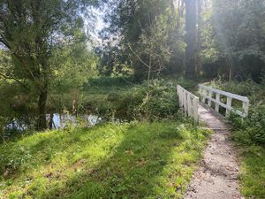
| − | + | xnyhps: Everything went according to plan! The hash was essentially on the path, so it was not difficult to reach. Despite really close to a highway, the forest was surprisingly nice. Went back through Amelisweerd on the other side, which was a lot quieter and also very nice. | |
| − | |||
| − | |||
| − | |||
== Photos == | == Photos == | ||
| Line 24: | Line 22: | ||
--> | --> | ||
<gallery perrow="5"> | <gallery perrow="5"> | ||
| + | Image:2023-10-15 52_5_1_start.jpeg | Starting point of the walk | ||
| + | Image:2023-10-15 52_5_2_bridge.jpeg | Looking down from the bridge | ||
| + | Image:2023-10-15_52_5_3_Soccer_field.jpeg | The soccer fields on one side | ||
| + | Image:2023-10-15_52_5_4_Nice_area.jpeg | This was a pretty nice park, considering its location | ||
| + | Image:2023-10-15_52_5_5_the_hashpoint.jpeg | The hash is somewhere in this picture | ||
| + | Image:2023-10-15_52_5_6_the_highway.jpeg | Passing over the highway | ||
| + | Image:2023-10-15 52 5 6 Amelisweerd.jpeg | Through Amelisweerd for the return trip | ||
| + | Image:2023-10-15_52_5_7_Nice_weather.jpeg | Pretty nice weather | ||
| + | Image:2023-10-15_52_5_8_Proof.png | GPS proof | ||
</gallery> | </gallery> | ||
| + | |||
| + | |||
| + | ==Tracklog== | ||
| + | {{tracklog|2023-10-15 52 5 Tracklog.gpx}} | ||
== Achievements == | == Achievements == | ||
{{#vardefine:ribbonwidth|100%}} | {{#vardefine:ribbonwidth|100%}} | ||
| − | |||
| − | |||
| − | |||
| − | |||
| − | |||
[[Category:Expeditions]] | [[Category:Expeditions]] | ||
| − | |||
[[Category:Expeditions with photos]] | [[Category:Expeditions with photos]] | ||
| − | |||
| − | |||
| − | |||
| − | |||
| − | |||
[[Category:Coordinates reached]] | [[Category:Coordinates reached]] | ||
| − | |||
| − | |||
| − | |||
| − | |||
| − | |||
| − | |||
| − | |||
| − | |||
| − | |||
| − | |||
| − | |||
| − | |||
| − | |||
| − | |||
| − | |||
| − | |||
| − | |||
| − | |||
{{location|NL|UT}} | {{location|NL|UT}} | ||
Latest revision as of 21:08, 24 May 2024
| Sun 15 Oct 2023 in 52,5: 52.0751256, 5.1544645 geohashing.info google osm bing/os kml crox |
Location
This Geohash is located in a forest in Utrecht.
Participants
Plans
xnyhps: The hash was in a narrow forest in between some soccer fields and a highway. As I didn't feel like cycling a long distance that day, I decided to take the car, park it near the Zwembad de Krommerijn and walk to the hash point, possibly making it a loop through Amelisweerd.
Expedition
xnyhps: Everything went according to plan! The hash was essentially on the path, so it was not difficult to reach. Despite really close to a highway, the forest was surprisingly nice. Went back through Amelisweerd on the other side, which was a lot quieter and also very nice.
Photos
Tracklog


