Difference between revisions of "2023-12-31 47 -122"
Coyotebush (talk | contribs) (→Photos: rearrange) |
m (subst-ing) |
||
| (3 intermediate revisions by 2 users not shown) | |||
| Line 22: | Line 22: | ||
--> | --> | ||
| − | * [[User:Coyotebush| | + | * [[User:Coyotebush|coyotebush]] |
| + | * [[User:Zebburkeconte|Zebburkeconte]] | ||
== Plans == | == Plans == | ||
| Line 32: | Line 33: | ||
<!-- how it all turned out. your narrative goes here. --> | <!-- how it all turned out. your narrative goes here. --> | ||
| + | === coyotebush === | ||
| + | Flashbacks to [[2017-12-09 47 -122|2017-12-09]] on account of the similar location and weather. | ||
| + | |||
| + | By midday it was sunny and nearly 50F/10C. I geared up for my first bike ride in nearly two weeks, and my first without an indoor destination in much longer. I decided on a light jacket and cycling tights, but packed hiking pants in my handlebar bag in case they were needed for the forest. | ||
| + | |||
| + | In order to approach the point from above, I climbed Interlaken Boulevard, then followed [https://www.seattle.gov/transportation/projects-and-programs/programs/greenways-program Neighborhood Greenway] routes through Capitol Hill and the Central District to South Jackson Street. | ||
| + | |||
| + | [[Image:2023-12-31 47 -122 coyotebush 1704062409039.jpg|frameless]] | ||
| + | |||
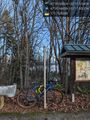
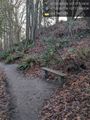
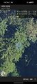
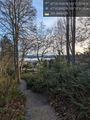
| + | Once on foot, I first tried the upper trail. Below this was mostly cliff. However, in the area of the point, there was a gently sloping spur, thick with brush. Promising. Next I descended quite a few stairs to the lower trail, above which was all cliff. Not promising. | ||
| + | |||
| + | [[Image:2023-12-31_47_-122_coyotebush_1704071898345.jpg|frameless]] | ||
| + | [[Image:2023-12-31_47_-122_coyotebush_1704071928707.jpg|frameless]] | ||
| + | |||
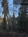
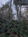
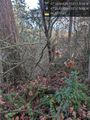
| + | The vegetation on the upper spur necessitated better clothing, so back to the bike for the pants, then to a bench I had passed to pull them on. I ventured off the upper trail, getting snagged and nearly tripped by blackberry vines. My phone's GPS location bounced around a lot in this area, but I got a few close readings and made it out to the large tree anchoring the spur, which seemed to be in about the right location. | ||
| + | |||
| + | [[Image:2023-12-31 47 -122 coyotebush 1704063685405.jpg|frameless]] | ||
| + | |||
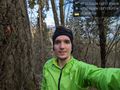
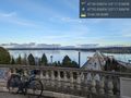
| + | There were beautiful views of Lake Washington and Mount Rainier through the trees. For the ride back north, I sought out better views along Lake Washington Boulevard - a popular recreational cycling route which also passes through Frink Park, another level lower. I met a neighbor who offered to take my photo, then a very nice concessionaire at Madison Park (I never knew there even was a concession stand!) who sold me a hot cocoa. | ||
| + | |||
| + | === Zebburkeconte === | ||
*Reached! Walk Geohash as well for me. Dragged my friend Felix along, though he didn't walk. -- [[User:Zebburkeconte|Zebburkeconte]] ([[User talk:Zebburkeconte|talk]]) 20:37, 31 December 2023 (PST) | *Reached! Walk Geohash as well for me. Dragged my friend Felix along, though he didn't walk. -- [[User:Zebburkeconte|Zebburkeconte]] ([[User talk:Zebburkeconte|talk]]) 20:37, 31 December 2023 (PST) | ||
| − | |||
| − | |||
== Photos == | == Photos == | ||
| Line 74: | Line 94: | ||
<!-- Add any achievement ribbons you earned below, or remove this section --> | <!-- Add any achievement ribbons you earned below, or remove this section --> | ||
| − | + | {{bicycle geohash | |
| − | + | | latitude=47 | |
| − | + | | longitude=-122 | |
| − | + | | date=2023-12-31 | |
| + | | name=coyotebush | ||
| + | }} | ||
| − | + | {{walk geohash | |
| + | | latitude=47 | ||
| + | | longitude=-122 | ||
| + | | date=2023-12-31 | ||
| + | | name=Zebburkeconte | ||
| + | }} | ||
| − | + | __NOTOC__ | |
| − | |||
| − | |||
| − | |||
| − | |||
[[Category:Expeditions]] | [[Category:Expeditions]] | ||
| − | |||
[[Category:Expeditions with photos]] | [[Category:Expeditions with photos]] | ||
| − | |||
| − | |||
| − | |||
| − | |||
| − | |||
[[Category:Coordinates reached]] | [[Category:Coordinates reached]] | ||
| − | + | {{location|US|WA|KN}} | |
| − | |||
| − | |||
| − | |||
| − | |||
| − | |||
| − | |||
| − | |||
| − | |||
| − | |||
| − | |||
| − | |||
| − | |||
| − | |||
| − | |||
| − | |||
| − | |||
| − | |||
Latest revision as of 21:12, 24 May 2024
| Sun 31 Dec 2023 in 47,-122: 47.5988040, -122.2919734 geohashing.info google osm bing/os kml crox |
Location
Frink Park in the Leschi neighborhood.
Close to a trail, but the hillside is steep and the vegetation is dense.
Participants
Plans
Perhaps mid-afternoon?
Expedition
coyotebush
Flashbacks to 2017-12-09 on account of the similar location and weather.
By midday it was sunny and nearly 50F/10C. I geared up for my first bike ride in nearly two weeks, and my first without an indoor destination in much longer. I decided on a light jacket and cycling tights, but packed hiking pants in my handlebar bag in case they were needed for the forest.
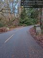
In order to approach the point from above, I climbed Interlaken Boulevard, then followed Neighborhood Greenway routes through Capitol Hill and the Central District to South Jackson Street.

Once on foot, I first tried the upper trail. Below this was mostly cliff. However, in the area of the point, there was a gently sloping spur, thick with brush. Promising. Next I descended quite a few stairs to the lower trail, above which was all cliff. Not promising.


The vegetation on the upper spur necessitated better clothing, so back to the bike for the pants, then to a bench I had passed to pull them on. I ventured off the upper trail, getting snagged and nearly tripped by blackberry vines. My phone's GPS location bounced around a lot in this area, but I got a few close readings and made it out to the large tree anchoring the spur, which seemed to be in about the right location.

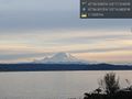
There were beautiful views of Lake Washington and Mount Rainier through the trees. For the ride back north, I sought out better views along Lake Washington Boulevard - a popular recreational cycling route which also passes through Frink Park, another level lower. I met a neighbor who offered to take my photo, then a very nice concessionaire at Madison Park (I never knew there even was a concession stand!) who sold me a hot cocoa.
Zebburkeconte
- Reached! Walk Geohash as well for me. Dragged my friend Felix along, though he didn't walk. -- Zebburkeconte (talk) 20:37, 31 December 2023 (PST)
Photos
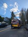
Trolleybus trouble blocking traffic
Parked bike at top of hill @47.5991,-122.2925
From trail above @47.5988,-122.2921
From trail below @47.5989,-122.2916
Handy bench @47.5995,-122.2923
Halfway from trail to tree @47.5987,-122.2918
It's near this tree @47.5989,-122.2920
Best GPS reading
Nearby view towards Mt Rainier @47.5982,-122.2920
Viewpoint over Lake Washington @47.5904,-122.2889
Road through Frink Park @47.5992,-122.2907
Best Rainier view of the day @47.6139,-122.2814
Close enough!


Achievements
coyotebush earned the Bicycle geohash achievement
|
Zebburkeconte earned the Walk geohash Achievement
|