Difference between revisions of "2024-01-18 -23 -46"
([live picture]Uphill to the subway) |
m (Location) |
||
| (9 intermediate revisions by 2 users not shown) | |||
| Line 1: | Line 1: | ||
| − | + | {{meetup graticule | |
| − | |||
| − | |||
| − | |||
| − | |||
| − | |||
| − | |||
| − | |||
| − | |||
| lat=-23 | | lat=-23 | ||
| lon=-46 | | lon=-46 | ||
| date=2024-01-18 | | date=2024-01-18 | ||
| − | }} | + | }} |
== Location == | == Location == | ||
| − | + | Brigadeiro Luiz Antonio Avenue, a large commercial / services avenue near(ish) Sao Paulo downtown. | |
== Participants == | == Participants == | ||
| − | + | *[[User:Shugyosha|Shugyosha]] | |
| − | |||
== Plans == | == Plans == | ||
| − | |||
*This street is in my way home by bus. Will ride through the geohash at about 18h30. -- [[User:Shugyosha|Shugyosha]] ([[User talk:Shugyosha|talk]]) 15:01, 18 January 2024 (GMT-03:00) | *This street is in my way home by bus. Will ride through the geohash at about 18h30. -- [[User:Shugyosha|Shugyosha]] ([[User talk:Shugyosha|talk]]) 15:01, 18 January 2024 (GMT-03:00) | ||
== Expedition == | == Expedition == | ||
| − | + | This hash is on Brigadeiro Luiz Antonio Avenue, a large avenue leading from Sao Paulo downtown to Southwest of the city. It has lots of office buildings, medical offices, and other services. The hashpoint is close to two very famous Sao Paulo landmarks, [[wikipedia:Paulista Avenue|Paulista Avenue]] and [[wikipedia:Ibirapuera Park|Ibirapuera Park]]. | |
| + | |||
| + | More importantly for my case, this avenue has a lot of bus transit, including a bus line connecting my apartment (actually, my girlfriend's) to my work. I usually bypass it by riding the subway, a lot more efficient commute given Sao Paulo's awful traffic. For the last month or so, though, a small traffic reduction due to summer vacations had me riding this bus more often (in fact, I had passed by the hash location that morning, about four hours before it was calculated). Upon seeing the location, I planned to ride the bus back home so I'd pass at the hashpoint again. | ||
| − | + | Alas, it wasn't so simple. A couple of summer rainshowers messed up my timing (and REALLY messed up traffic), so I went to the subway instead. But I still wanted to get to this easy hashpoint, so didn't go straight home. I left at Brigadeiro staion, near Paulista and Brigadeiro avenues corner, then walked to the hashpoint. Paulista Avenue sits on a ridge, splitting Downtown and West side of the city. That means the walk to the hashpoint was downhill, about 600 meters, quite easy. The hash was a typical urban location, street, buildings, no special features. I had briefly considered going to the park, but the rainy weather made me give up. After visiting the point, the walk back to the subway would be uphill. I got lazy, just went to a bus stop a block away, and waited for the bus I would have used on my original plan. | |
| − | |||
== Photos == | == Photos == | ||
| − | |||
| − | |||
| − | |||
<gallery perrow="5"> | <gallery perrow="5"> | ||
| − | |||
| − | |||
| − | |||
| − | |||
| − | |||
| − | |||
| − | |||
Image:2024-01-18_-23_-46_shugyosha_1705614711612.jpg|Uphill to the subway | Image:2024-01-18_-23_-46_shugyosha_1705614711612.jpg|Uphill to the subway | ||
| + | Image:2024-01-18_-23_-46_shugyosha_1705614790618.jpg|Screenshot | ||
| + | Image:2024-01-18_-23_-46_shugyosha_1705614931848.jpg|Closest point on the sidewalk | ||
</gallery> | </gallery> | ||
| Line 49: | Line 32: | ||
__NOTOC__ | __NOTOC__ | ||
| − | |||
| − | |||
| − | |||
| − | |||
| − | |||
| − | |||
| − | |||
| − | |||
| − | |||
| − | |||
| − | |||
| − | |||
| − | |||
| − | |||
[[Category:Expeditions]] | [[Category:Expeditions]] | ||
| − | |||
[[Category:Expeditions with photos]] | [[Category:Expeditions with photos]] | ||
| − | |||
| − | |||
| − | |||
| − | |||
| − | |||
[[Category:Coordinates reached]] | [[Category:Coordinates reached]] | ||
| − | + | {{location|BR|SP}} | |
| − | |||
| − | |||
| − | |||
| − | |||
| − | |||
| − | |||
| − | |||
| − | |||
| − | |||
| − | |||
| − | |||
| − | |||
| − | |||
| − | |||
| − | |||
| − | |||
| − | |||
Latest revision as of 15:06, 29 January 2024
| Thu 18 Jan 2024 in -23,-46: -23.5718063, -46.6532429 geohashing.info google osm bing/os kml crox |
Location
Brigadeiro Luiz Antonio Avenue, a large commercial / services avenue near(ish) Sao Paulo downtown.
Participants
Plans
- This street is in my way home by bus. Will ride through the geohash at about 18h30. -- Shugyosha (talk) 15:01, 18 January 2024 (GMT-03:00)
Expedition
This hash is on Brigadeiro Luiz Antonio Avenue, a large avenue leading from Sao Paulo downtown to Southwest of the city. It has lots of office buildings, medical offices, and other services. The hashpoint is close to two very famous Sao Paulo landmarks, Paulista Avenue and Ibirapuera Park.
More importantly for my case, this avenue has a lot of bus transit, including a bus line connecting my apartment (actually, my girlfriend's) to my work. I usually bypass it by riding the subway, a lot more efficient commute given Sao Paulo's awful traffic. For the last month or so, though, a small traffic reduction due to summer vacations had me riding this bus more often (in fact, I had passed by the hash location that morning, about four hours before it was calculated). Upon seeing the location, I planned to ride the bus back home so I'd pass at the hashpoint again.
Alas, it wasn't so simple. A couple of summer rainshowers messed up my timing (and REALLY messed up traffic), so I went to the subway instead. But I still wanted to get to this easy hashpoint, so didn't go straight home. I left at Brigadeiro staion, near Paulista and Brigadeiro avenues corner, then walked to the hashpoint. Paulista Avenue sits on a ridge, splitting Downtown and West side of the city. That means the walk to the hashpoint was downhill, about 600 meters, quite easy. The hash was a typical urban location, street, buildings, no special features. I had briefly considered going to the park, but the rainy weather made me give up. After visiting the point, the walk back to the subway would be uphill. I got lazy, just went to a bus stop a block away, and waited for the bus I would have used on my original plan.
Photos
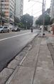
Uphill to the subway
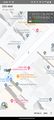
Screenshot
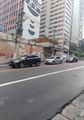
Closest point on the sidewalk


