Difference between revisions of "2024-03-30 66 29"
m (subst-ing) |
|||
| (6 intermediate revisions by 2 users not shown) | |||
| Line 1: | Line 1: | ||
{{meetup graticule | {{meetup graticule | ||
| − | | lat= | + | | lat=66 |
| − | | lon= | + | | lon=29 |
| − | | date= | + | | date=2024-03-30 |
}} | }} | ||
== Location == | == Location == | ||
In the forest next to a road near Takajärvi, Kuusamo. | In the forest next to a road near Takajärvi, Kuusamo. | ||
| − | The point on a topographic map: [https://kripakko.neocities.org/geohash_maplink? | + | The point on a topographic map: [https://kripakko.neocities.org/geohash_maplink?2024-03-30_66_29K] |
== Participants == | == Participants == | ||
| Line 13: | Line 13: | ||
== Expedition == | == Expedition == | ||
| − | + | We were in Kuusamo at Easter, having a long weekend, and I noticed that this hashpoint was in a rather lucky spot. | |
| + | It was reasonably near and next to a road that would likely be kept open in the winter, and I felt like going adventuring and driving to it. | ||
| + | After other activities today, I left late in the afternoon but early enough to have sufficient daylight for taking photos. | ||
| + | |||
| + | As I went, I found out that the road was indeed open and easy to traverse by car. | ||
| + | It was snowing a little, not so much that the car would get stuck but enough to make the countryside roads slightly slippery. | ||
| + | To my surprise, when I was on the final stretch approaching the hashpoint, there was a herd of reindeer blocking the road. | ||
| + | Reindeer are populous in Northern Finland and mostly roam around freely in herds, but in the winter they stay in pens where they are fed. | ||
| + | There was apparently such a pen right here, and the reindeer were free to walk around in the vicinity, including across the road. | ||
| + | I had to wait for a while until the road was clear. | ||
| + | |||
| + | I drove past the hashpoint and found a place where I could turn the car around. | ||
| + | Maybe I could have done so on the spot had I been careful, but I wanted to play it safe. | ||
| + | Despite the road looking pretty wide, the fringes were potentially soft, and the car might very well get stuck there. | ||
| + | I then stopped on the road, making sure I did not block it, and went to visit the hashpoint which turned out to be 15 metres off the road. | ||
| + | The forest was covered in almost a metre of snow, which I could manage wearing tall rubber boots. | ||
| + | Going further would have been easy enough with snowshoes or short skis, at least in level terrain like this. | ||
| + | |||
| + | I then drove back to the town and refuelled the car. 95-octane (RON) gasoline cost 2.00 EUR per litre | ||
| + | (for Americans, 8.18 USD per gallon) today, argh. | ||
| + | Still not nearly as expensive as two years ago when the prices skyrocketed after the war in Ukraine escalated. | ||
| + | |||
| + | The length of my trip was about 62 kilometres. | ||
== Tracklog == | == Tracklog == | ||
| − | |||
{{Tracklog|2024-03-30 66 29.gpx}} | {{Tracklog|2024-03-30 66 29.gpx}} | ||
== Photos == | == Photos == | ||
| − | <gallery perrow=" | + | <gallery perrow="6"> |
| + | Image:2024-03-30 66 29 01-road.jpg | You are being watched... by the national border guard. | ||
| + | Image:2024-03-30 66 29 02-reindeer.jpg | Reindeer temporarily blocking the road. | ||
| + | Image:2024-03-30 66 29 03-temperature.jpg | Proof of temperature. | ||
| + | Image:2024-03-30 66 29 04-car.jpg | The car parked next to the hashpoint. | ||
| + | Image:2024-03-30 66 29 05-selfie.jpg | Stupid Grin™ | ||
| + | Image:2024-03-30 66 29 06-qdgn.png | Proof of location, screenshot of [https://kripakko.neocities.org/qdgn QDGN]. | ||
</gallery> | </gallery> | ||
| Line 28: | Line 55: | ||
{{land geohash | {{land geohash | ||
| name = [[User:Kripakko|Kripakko]] | | name = [[User:Kripakko|Kripakko]] | ||
| − | | latitude = | + | | latitude = 66 | longitude = 29 | date = 2024-03-30 |
}} | }} | ||
{{frozen geohash | {{frozen geohash | ||
| name = [[User:Kripakko|Kripakko]] | | name = [[User:Kripakko|Kripakko]] | ||
| − | | latitude = | + | | latitude = 66 | longitude = 29 | date = 2024-03-30 |
| temperature = −6 °C | | temperature = −6 °C | ||
}} | }} | ||
__NOTOC__ | __NOTOC__ | ||
| − | |||
| − | |||
| − | |||
| − | |||
| − | |||
| − | |||
| − | |||
| − | |||
| − | |||
| − | |||
| − | |||
| − | |||
| − | |||
[[Category:Expeditions]] | [[Category:Expeditions]] | ||
| − | |||
[[Category:Expeditions with photos]] | [[Category:Expeditions with photos]] | ||
| − | |||
| − | |||
| − | |||
| − | |||
| − | |||
[[Category:Coordinates reached]] | [[Category:Coordinates reached]] | ||
| − | + | {{location|FI|14}} | |
| − | |||
| − | |||
| − | |||
| − | |||
| − | |||
| − | |||
| − | |||
| − | |||
| − | |||
| − | |||
| − | |||
| − | |||
| − | |||
| − | |||
| − | |||
| − | |||
| − | |||
Latest revision as of 21:18, 24 May 2024
| Sat 30 Mar 2024 in 66,29: 66.0043165, 29.6374159 geohashing.info google osm bing/os kml crox |
Location
In the forest next to a road near Takajärvi, Kuusamo.
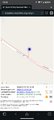
The point on a topographic map: [1]
Participants
Expedition
We were in Kuusamo at Easter, having a long weekend, and I noticed that this hashpoint was in a rather lucky spot. It was reasonably near and next to a road that would likely be kept open in the winter, and I felt like going adventuring and driving to it. After other activities today, I left late in the afternoon but early enough to have sufficient daylight for taking photos.
As I went, I found out that the road was indeed open and easy to traverse by car. It was snowing a little, not so much that the car would get stuck but enough to make the countryside roads slightly slippery. To my surprise, when I was on the final stretch approaching the hashpoint, there was a herd of reindeer blocking the road. Reindeer are populous in Northern Finland and mostly roam around freely in herds, but in the winter they stay in pens where they are fed. There was apparently such a pen right here, and the reindeer were free to walk around in the vicinity, including across the road. I had to wait for a while until the road was clear.
I drove past the hashpoint and found a place where I could turn the car around. Maybe I could have done so on the spot had I been careful, but I wanted to play it safe. Despite the road looking pretty wide, the fringes were potentially soft, and the car might very well get stuck there. I then stopped on the road, making sure I did not block it, and went to visit the hashpoint which turned out to be 15 metres off the road. The forest was covered in almost a metre of snow, which I could manage wearing tall rubber boots. Going further would have been easy enough with snowshoes or short skis, at least in level terrain like this.
I then drove back to the town and refuelled the car. 95-octane (RON) gasoline cost 2.00 EUR per litre (for Americans, 8.18 USD per gallon) today, argh. Still not nearly as expensive as two years ago when the prices skyrocketed after the war in Ukraine escalated.
The length of my trip was about 62 kilometres.
Tracklog
Photos
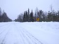
You are being watched... by the national border guard.
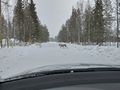
Reindeer temporarily blocking the road.
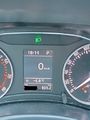
Proof of temperature.
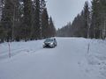
The car parked next to the hashpoint.
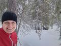
Stupid Grin™
Proof of location, screenshot of QDGN.


Achievements
Kripakko earned the Land geohash achievement
|
Kripakko earned the Frozen Geohash Achievement
|