Difference between revisions of "2024-06-25 58 5"
From Geohashing
(→Photos) |
(→Photos) |
||
| (7 intermediate revisions by the same user not shown) | |||
| Line 8: | Line 8: | ||
And DON'T FORGET to add your expedition and the best photo you took to the gallery on the Main Page! We'd love to read your report, but that means we first have to discover it! :) | And DON'T FORGET to add your expedition and the best photo you took to the gallery on the Main Page! We'd love to read your report, but that means we first have to discover it! :) | ||
-->{{meetup graticule|date=2024-06-25|lat=58|lon=5}} | -->{{meetup graticule|date=2024-06-25|lat=58|lon=5}} | ||
| − | + | <!-- edit as necessary --> | |
[[Image:20240625 090827.jpg|thumb|left]] | [[Image:20240625 090827.jpg|thumb|left]] | ||
== Location == | == Location == | ||
| Line 26: | Line 26: | ||
== Expedition == | == Expedition == | ||
<!-- how it all turned out. your narrative goes here. --> | <!-- how it all turned out. your narrative goes here. --> | ||
| + | |||
| + | This geohash was located on an island in Hafrsfjord, near Tananger, Rogaland, Norway. Fortunately, there is a tractor road over to the island. The only living creatures I met on the island were a flock of sheep and two horses. | ||
== Tracklog == | == Tracklog == | ||
| Line 39: | Line 41: | ||
Image:2024-06-25_58_5_Pica42_1719299418659.jpg|Hafrsfjord [https://openstreetmap.org/?mlat=58.92796520&mlon=5.63417590&zoom=16 @58.9280,5.6342] | Image:2024-06-25_58_5_Pica42_1719299418659.jpg|Hafrsfjord [https://openstreetmap.org/?mlat=58.92796520&mlon=5.63417590&zoom=16 @58.9280,5.6342] | ||
| − | Image:20240625 58 5 S.jpg|thumb | + | Image:20240625 58 5 S.jpg|thumb|View to the south |
| − | + | Image:20240625 58 5 E.jpg|thumb|View to the east | |
| − | + | Image:20240625_58 5 N.jpg|thumb|View to the north | |
| − | + | Image:20240625 58 5 W.jpg|thumb|View to the west | |
| + | Image:20240625 091946.jpg|thumb|A beautiful horse grazing. | ||
</gallery> | </gallery> | ||
| Line 49: | Line 52: | ||
<!-- Add any achievement ribbons you earned below, or remove this section --> | <!-- Add any achievement ribbons you earned below, or remove this section --> | ||
| − | + | {{land geohash |name=[[User:Pica42|Pica42]] |date=2024-06-25 |latitude=58 |longitude=5 }} | |
| − | |||
| − | |||
| − | [[ | ||
| − | |||
| − | |||
| − | |||
| − | |||
| − | |||
| − | |||
| − | |||
[[Category:Expeditions]] | [[Category:Expeditions]] | ||
| − | |||
[[Category:Expeditions with photos]] | [[Category:Expeditions with photos]] | ||
| − | |||
| − | |||
| − | |||
| − | |||
[[Category:Coordinates reached]] | [[Category:Coordinates reached]] | ||
| + | {{location|NO|11}} | ||
| − | + | __NOTOC__ | |
| − | |||
| − | |||
| − | |||
| − | |||
| − | |||
| − | |||
| − | |||
| − | |||
| − | |||
| − | |||
| − | |||
| − | |||
Latest revision as of 17:30, 29 June 2024
| Tue 25 Jun 2024 in 58,5: 58.9279647, 5.6341936 geohashing.info google osm bing/os kml crox |

Location
On the island of Hagøyna in Sola municipality in the fjord Hafrsfjord, Norway.
Participants
Plans
Expedition
This geohash was located on an island in Hafrsfjord, near Tananger, Rogaland, Norway. Fortunately, there is a tractor road over to the island. The only living creatures I met on the island were a flock of sheep and two horses.
Tracklog
Photos

Hafrsfjord @58.9280,5.6342
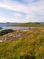
View to the south
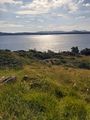
View to the east
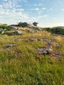
View to the north
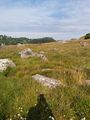
View to the west
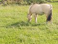
A beautiful horse grazing.


Achievements
Pica42 earned the Land geohash achievement
|