Difference between revisions of "2024-07-21 47 7"
m (Location) |
(→Expedition: Add section) |
||
| (One intermediate revision by the same user not shown) | |||
| Line 5: | Line 5: | ||
}} | }} | ||
== Location == | == Location == | ||
| − | In a | + | In a harvested field in [[wikipedia:Rouffach|Rouffach]]. |
== Participants == | == Participants == | ||
| Line 12: | Line 12: | ||
== Plans == | == Plans == | ||
[[User:Baarde|Baarde]] will take the train to Rouffach, then cycle to the coordinates. He expects to arrive at 23:20. | [[User:Baarde|Baarde]] will take the train to Rouffach, then cycle to the coordinates. He expects to arrive at 23:20. | ||
| + | |||
| + | == Expedition == | ||
| + | I had spent the day in Strasbourg, then taken half the evening making preparations for the coming week. It was now time for any reasonable person to go to the bed. But I'm not a reasonable person. | ||
| + | |||
| + | I decided to take the last trains to and from Rouffach with 50 minutes of layover time, which was enough to visit the coordinates and account for minor difficulties, such as a slight train delay, taking a few wrong turns, and being asked for directions by a German taxi driver. | ||
| + | |||
| + | The coordinates weren't located in a cornfield, as the satellite image suggested. So instead of walking 200 meters between rows of cornstalks, I was able to cycle across a harvested wheatfield up to the hashpoint. I recorded proof, then cycled back to the train station. | ||
| + | |||
| + | It was a fun expedition. Gravel cycling in the dark was a little bit scary but also exhilarating. | ||
| + | |||
| + | == Photos == | ||
| + | <gallery> | ||
| + | File:2024-07-21 47 7 01.jpg | In Rouffach | ||
| + | File:2024-07-21 47 7 02.jpg | My bicycle at the geohash | ||
| + | File:2024-07-21 47 7 03.jpg | Surroundings (South-East) | ||
| + | File:2024-07-21 47 7 04.jpg | Surroundings (North-West) | ||
| + | File:2024-07-21 47 7 05.png | Coordinates reached | ||
| + | File:2024-07-21 47 7 06.jpg | Stupid grin | ||
| + | </gallery> | ||
| + | |||
| + | == Achievements == | ||
| + | {{#vardefine:ribbonwidth|100%}} | ||
| + | {{land geohash | ||
| + | | latitude = 47 | ||
| + | | longitude = 7 | ||
| + | | date = 2024-07-21 | ||
| + | | name = [[User:Baarde|Baarde]] | ||
| + | }} | ||
__NOTOC__ | __NOTOC__ | ||
[[Category:Expeditions]] | [[Category:Expeditions]] | ||
| + | [[Category:Expeditions with photos]] | ||
| + | [[Category:Coordinates reached]] | ||
{{location|FR|68}} | {{location|FR|68}} | ||
Latest revision as of 12:23, 24 July 2024
| Sun 21 Jul 2024 in 47,7: 47.9326059, 7.2731786 geohashing.info google osm bing/os kml crox |
Location
In a harvested field in Rouffach.
Participants
Plans
Baarde will take the train to Rouffach, then cycle to the coordinates. He expects to arrive at 23:20.
Expedition
I had spent the day in Strasbourg, then taken half the evening making preparations for the coming week. It was now time for any reasonable person to go to the bed. But I'm not a reasonable person.
I decided to take the last trains to and from Rouffach with 50 minutes of layover time, which was enough to visit the coordinates and account for minor difficulties, such as a slight train delay, taking a few wrong turns, and being asked for directions by a German taxi driver.
The coordinates weren't located in a cornfield, as the satellite image suggested. So instead of walking 200 meters between rows of cornstalks, I was able to cycle across a harvested wheatfield up to the hashpoint. I recorded proof, then cycled back to the train station.
It was a fun expedition. Gravel cycling in the dark was a little bit scary but also exhilarating.
Photos
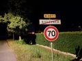
In Rouffach
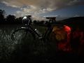
My bicycle at the geohash
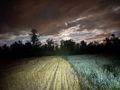
Surroundings (South-East)
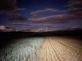
Surroundings (North-West)

Coordinates reached
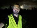
Stupid grin


Achievements
Baarde earned the Land geohash achievement
|