Difference between revisions of "2024-07-20 -37 145"
Felix Dance (talk | contribs) (An expedition message sent via Geohash Droid for Android.) |
m (Location) |
||
| (8 intermediate revisions by 4 users not shown) | |||
| Line 1: | Line 1: | ||
| − | + | [[Image:2024-07-20_-37_145_Felix Dance _1721878660312.jpg|thumb|left]] | |
| − | + | {{meetup graticule|date=2024-07-20|lat=-37|lon=145}} | |
| − | [[Image: | ||
| − | |||
| − | |||
| − | |||
| − | |||
| − | |||
| − | |||
== Location == | == Location == | ||
| − | + | Just off the Lilydale-Warburton Rail Trail. | |
== Participants == | == Participants == | ||
| − | + | *[[User:Gimcrack|Gimcrack]] | |
| − | |||
| − | |||
| − | |||
| − | |||
== Expedition == | == Expedition == | ||
| − | + | I went to this geohash in the rain. I was on a tight timetable, passing through towards the city, so drove to the closest road crossing, which is Burgi Hill Rd. I must have crossed this road hundreds of times before on my bike, but this is the first time to get there in a car! There were streams running down Burgi Hill Rd, and numerous small lakes along the rail trail, so no surprise that I had it to myself as I jogged the 200 m up the trail to the hash. For those of you familiar with the rail trail, the hash was close to the derelict flower farm (as depicted below). My umbrella seemed to provide the perfect marker for the spot, despite the obvious risk of getting a bit rained on in the meantime. | |
| − | + | Hash in the bag, I hightailed it back to the car and the comfort of climate control. | |
| − | |||
== Photos == | == Photos == | ||
| − | |||
| − | |||
| − | |||
<gallery perrow="5"> | <gallery perrow="5"> | ||
| + | Image:2024-07-20_-37_145_Gimcrack_Screenshot_20240720-135417.png|Proof | ||
| + | Image:2024-07-22_-37_145_Gimcrack_View towards the hash.jpg|Damp day on the trail | ||
| + | Image:2024-07-20_-37_145_Felix Dance _1721878660312.jpg|Umbrella near the hash | ||
| + | Image:2024-07-20_-37_145_Gimcrack_Derelict flower farm.jpg|The derelict tunnels of the flower farm | ||
</gallery> | </gallery> | ||
== Achievements == | == Achievements == | ||
| − | |||
| − | |||
| − | |||
| − | |||
| − | |||
| − | |||
| − | |||
| − | |||
| − | |||
| − | |||
| − | |||
| − | |||
[[Category:Expeditions]] | [[Category:Expeditions]] | ||
| − | |||
[[Category:Expeditions with photos]] | [[Category:Expeditions with photos]] | ||
| − | |||
| − | |||
| − | |||
| − | |||
[[Category:Coordinates reached]] | [[Category:Coordinates reached]] | ||
| − | + | {{location|AU|VIC|YR}} | |
| − | |||
| − | |||
| − | |||
| − | |||
| − | |||
| − | |||
| − | |||
| − | |||
| − | |||
| − | |||
| − | |||
| − | |||
| − | |||
Latest revision as of 21:42, 25 July 2024

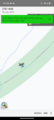
| Sat 20 Jul 2024 in -37,145: -37.7758697, 145.4415353 geohashing.info google osm bing/os kml crox |
Location
Just off the Lilydale-Warburton Rail Trail.
Participants
Expedition
I went to this geohash in the rain. I was on a tight timetable, passing through towards the city, so drove to the closest road crossing, which is Burgi Hill Rd. I must have crossed this road hundreds of times before on my bike, but this is the first time to get there in a car! There were streams running down Burgi Hill Rd, and numerous small lakes along the rail trail, so no surprise that I had it to myself as I jogged the 200 m up the trail to the hash. For those of you familiar with the rail trail, the hash was close to the derelict flower farm (as depicted below). My umbrella seemed to provide the perfect marker for the spot, despite the obvious risk of getting a bit rained on in the meantime.
Hash in the bag, I hightailed it back to the car and the comfort of climate control.
Photos
Proof
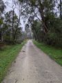
Damp day on the trail
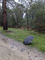
Umbrella near the hash
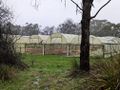
The derelict tunnels of the flower farm


