Difference between revisions of "2024-07-25 40 -84"
From Geohashing
m (→Participants) |
m (Location) |
||
| (7 intermediate revisions by one other user not shown) | |||
| Line 1: | Line 1: | ||
| − | + | {{meetup graticule|date=2024-07-25|lat=40|lon=-84}} | |
| − | |||
| − | |||
| − | |||
| − | |||
| − | |||
| − | |||
| − | |||
| − | |||
== Location == | == Location == | ||
<!-- where you've surveyed the hash to be --> | <!-- where you've surveyed the hash to be --> | ||
| + | On a road in Allen, Indiana | ||
== Participants == | == Participants == | ||
| Line 18: | Line 11: | ||
== Plans == | == Plans == | ||
<!-- what were the original plans --> | <!-- what were the original plans --> | ||
| + | After my last failed expedition, I was willing to drive a bit further to get a publicly-accessible hash. | ||
== Expedition == | == Expedition == | ||
<!-- how it all turned out. your narrative goes here. --> | <!-- how it all turned out. your narrative goes here. --> | ||
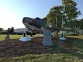
| + | [[User:Ironeagl|Ironeagl]] ([[User talk:Ironeagl|talk]]) : I left after work, and drove for quite a while. Near the hashpoint, I passed through Monroeville (unfortunately named after a U.S. President rather then Our Holy Founder). The hash was on the road, and I passed right over it! I did not stop long, though, as I had arrived just behind the owner of the property that fronted it, and I really did not want to be suspicious again. On the way back, I stopped at a display of an F84-F fighter-bomber outside Monroeville, which was interesting. | ||
| − | |||
| − | |||
== Tracklog == | == Tracklog == | ||
<!-- if your GPS device keeps a log, you may use Template:Tracklog, post a link here, or both --> | <!-- if your GPS device keeps a log, you may use Template:Tracklog, post a link here, or both --> | ||
| Line 33: | Line 26: | ||
--> | --> | ||
<gallery perrow="5"> | <gallery perrow="5"> | ||
| + | Image:2024-07-25 40 -84 Airplane.jpg | An airplane | ||
</gallery> | </gallery> | ||
| Line 40: | Line 34: | ||
__NOTOC__ | __NOTOC__ | ||
| − | |||
| − | |||
| − | |||
| − | |||
| − | |||
| − | |||
| − | |||
| − | |||
[[Category:Expeditions]] | [[Category:Expeditions]] | ||
| − | |||
[[Category:Expeditions with photos]] | [[Category:Expeditions with photos]] | ||
| − | |||
| − | |||
| − | |||
| − | |||
[[Category:Coordinates reached]] | [[Category:Coordinates reached]] | ||
| − | + | {{location|US|IN|AL}} | |
| − | |||
| − | |||
| − | |||
| − | |||
| − | |||
| − | |||
| − | |||
| − | |||
| − | |||
| − | |||
| − | |||
| − | |||
| − | |||
Latest revision as of 22:42, 26 July 2024
| Thu 25 Jul 2024 in 40,-84: 40.9505238, -84.8241047 geohashing.info google osm bing/os kml crox |
Location
On a road in Allen, Indiana
Participants
Plans
After my last failed expedition, I was willing to drive a bit further to get a publicly-accessible hash.
Expedition
Ironeagl (talk) : I left after work, and drove for quite a while. Near the hashpoint, I passed through Monroeville (unfortunately named after a U.S. President rather then Our Holy Founder). The hash was on the road, and I passed right over it! I did not stop long, though, as I had arrived just behind the owner of the property that fronted it, and I really did not want to be suspicious again. On the way back, I stopped at a display of an F84-F fighter-bomber outside Monroeville, which was interesting.
Tracklog
Photos
An airplane
