Difference between revisions of "2024-07-25 66 28"
m (Location) |
|||
| (One intermediate revision by one other user not shown) | |||
| Line 7: | Line 7: | ||
== Participants == | == Participants == | ||
* [[User:Kripakko|Kripakko]] | * [[User:Kripakko|Kripakko]] | ||
| − | * Kripakko | + | * Kripakko’s fiancée |
== Expedition == | == Expedition == | ||
| − | + | We had gone [https://en.wikipedia.org/wiki/Rubus_chamaemorus cloudberry] | |
| + | picking earlier today and got a very nice yield. | ||
| + | The day was sunny and hot (up to 27 °C), | ||
| + | and since we were pretty sweaty after spending several hours in the bog, | ||
| + | we went swimming in a lake afterwards. | ||
| + | On the way back to Kuusamo we made a quick stop so I could visit this hashpoint | ||
| + | that was conveniently almost next to the main road. | ||
| + | Fiancée drove up to the intersection of the radio mast, | ||
| + | and I walked the remaining short distance alone | ||
| + | first on the forest road and then in the forest. | ||
| + | There was a power line which I could have followed, | ||
| + | but it looked like there was impassable undergrowth under it, | ||
| + | and thus I chose to go through the forest which was not too easy to traverse either. | ||
| + | At the hashpoint, I saw that the line was clear after all and chose to follow it back to the forest road. | ||
| + | It turned out that there were bushy knolls only next to the forest road, | ||
| + | and I could make my way through them without too much difficulty. | ||
| + | Having just gone swimming, I was only wearing a towel and shoes, | ||
| + | which were not the ideal choice in a dense coniferous forest | ||
| + | with lots of hungry mosquitoes. | ||
== Photos == | == Photos == | ||
| Line 40: | Line 58: | ||
__NOTOC__ | __NOTOC__ | ||
| − | |||
| − | |||
| − | |||
[[Category:Expeditions]] | [[Category:Expeditions]] | ||
[[Category:Expeditions with photos]] | [[Category:Expeditions with photos]] | ||
[[Category:Coordinates reached]] | [[Category:Coordinates reached]] | ||
| − | + | {{location|FI|14}} | |
Latest revision as of 21:42, 27 July 2024
| Thu 25 Jul 2024 in 66,28: 66.0712023, 28.8783776 geohashing.info google osm bing/os kml crox |
Location
In a forest near Mäntyvaara, Kuusamo.
The point on a topographic map: [1]
Participants
- Kripakko
- Kripakko’s fiancée
Expedition
We had gone cloudberry picking earlier today and got a very nice yield. The day was sunny and hot (up to 27 °C), and since we were pretty sweaty after spending several hours in the bog, we went swimming in a lake afterwards. On the way back to Kuusamo we made a quick stop so I could visit this hashpoint that was conveniently almost next to the main road. Fiancée drove up to the intersection of the radio mast, and I walked the remaining short distance alone first on the forest road and then in the forest. There was a power line which I could have followed, but it looked like there was impassable undergrowth under it, and thus I chose to go through the forest which was not too easy to traverse either. At the hashpoint, I saw that the line was clear after all and chose to follow it back to the forest road. It turned out that there were bushy knolls only next to the forest road, and I could make my way through them without too much difficulty. Having just gone swimming, I was only wearing a towel and shoes, which were not the ideal choice in a dense coniferous forest with lots of hungry mosquitoes.
Photos
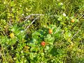
Ripe and delicious cloudberries (Rubus chamaemorus).
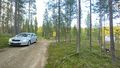
Where I continued on foot, about 160 metres to go.
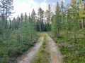
Forest road towards the hashpoint.
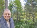
Selfie at the hashpoint.
Proof of location and time, screenshot of QDGN.
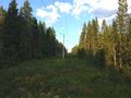
The power line that I followed on the way back.


Achievements
Kripakko earned the Land geohash achievement
|
Kripakko earned the Consecutive geohash achievement
|