Difference between revisions of "2024-07-29 -37 144"
([live picture]GPS proof) |
m (Location) |
||
| (3 intermediate revisions by one other user not shown) | |||
| Line 1: | Line 1: | ||
| − | + | {{meetup graticule|date=2024-07-29|lat=-37|lon=144}} | |
| − | |||
| − | |||
| − | |||
| − | |||
| − | |||
| − | |||
| − | |||
| − | |||
== Location == | == Location == | ||
| − | + | Lawrie Emmins Reserve, Laverton | |
== Participants == | == Participants == | ||
| − | + | [[User:Johnwrw|John]] | |
| − | |||
== Plans == | == Plans == | ||
| − | + | Very gettable geohash. It was only 350m or so from a [[2023-06-14_-37_144|successful hash]] of mine from last year, in the very same park. (Thanks Felix for that bare bones report, I don't know if it's ever getting a more comprehensive write up). What could go wrong? Not much. The weekend had been another damp and miserable one, but Monday's forecast looked better even if there might still be showers around. I planned to ride out first thing, so as to get home for still a reasonably productive day of thesisizing. | |
== Expedition == | == Expedition == | ||
| − | + | I got up at 8, and checked the BOM rain radar (located very close to today's hash location, as discovered on last year's mission). Looking good! Showers around, but none heading my direction. I started making some tea and preparing a breakfast. I then happened to glance out the window and got an unpleasant surprise. It was wet. The rain was apparently light enough to not be picked up by the radar, but exist it definitely did. | |
| + | |||
| + | By this point, I was too invested to back out. I put on a rainproof jacket and set off anyway. Maybe the mizzle would burn off soon, since it was evidently not significant enough for radar detection. It did not burn off. It even got stronger at times as I rode down to West Footscray station and then up the service lanes of Geelong Rd. Reaching the Newport-Sunshine railway line, I underpassed the Geelong Rd bridge using the service lane, and then underpassed the train line itself using the damp and dingy pedestrian tunnel. Now with not far until the Federation trail junction, I decided to be naughty and stay on this side of the road and go the wrong way up the service lane. But I discovered that the service lane here is actually two-ways, so I was not being naughty at all! But then the service lane ended, and I had to go up the footpath for the last little section. | ||
| + | |||
| + | I got on the Federation trail eventually and the ride from here was uneventful. Defining my previous experiences of this trail is smelliness. But today, it was for the most part unobjectionable to my nostrils. There was just one short section of odour (though it was quite bad for that short section). | ||
| + | |||
| + | As I neared the hash, the rain did finally start to ease up. My torso was still nice and warm under my jacket, but my lower limbs had not been so fortunate. My legs were cold and wet, while my brain hadn't received any reports of sensation at all from my toes in quite some time, my questionable choice of shoes and socks having been soaked through. | ||
| + | |||
| + | I reached the park and had about 400m to go across a grassy expanse. Inspired by the olympic mountain bikers I had watched last night, I decided I could cross country it on my road bike. And surprisingly, this turned out fine. I got to within about 40m of the hash, and then I thought I had to head into a patch of longer grass dotted with African Boxthorns. So I duly did this, the wet grass providing no respite for my ice-block feet despite the fact that it had stopped raining. I reached the point, and as it turned out, I could have just gone around the worst of the long grass, but oh well. I snapped a couple of pics, my selfie documenting a considerable number of water droplets suspended in my beard as I noticed only later. | ||
| − | + | I rode home back the way I came, and as I got closer, the rain returned. I arrived home very much a drowned rat. So, I had a hot shower and coaxed some tingly feeling back into my extremities. | |
| − | |||
== Photos == | == Photos == | ||
| − | + | ||
| − | + | <gallery heights="300px" mode="packed"> | |
| − | |||
| − | <gallery | ||
Image:2024-07-29_-37_144_Johnwrw_1722218460446.jpg|Success | Image:2024-07-29_-37_144_Johnwrw_1722218460446.jpg|Success | ||
| Line 39: | Line 35: | ||
== Achievements == | == Achievements == | ||
{{#vardefine:ribbonwidth|100%}} | {{#vardefine:ribbonwidth|100%}} | ||
| − | + | {{Drowned rat geohash | |
| + | | latitude = -37 | ||
| + | | longitude = 144 | ||
| + | | date = 2024-07-29 | ||
| + | | name = John | ||
| + | | reason = hydrometeors | ||
| + | }} | ||
| + | |||
| + | {{bicycle geohash|date=2024-07-29|latitude=-37|longitude=144|name=[[User:Johnwrw|Johnwrw]]|distance=33.8km|bothways=yes}} | ||
__NOTOC__ | __NOTOC__ | ||
| − | |||
| − | |||
| − | |||
| − | |||
| − | |||
| − | |||
| − | |||
| − | + | ||
[[Category:Expeditions]] | [[Category:Expeditions]] | ||
| − | + | ||
[[Category:Expeditions with photos]] | [[Category:Expeditions with photos]] | ||
| − | |||
| − | |||
| − | |||
| − | |||
| − | |||
| − | |||
| − | |||
| − | |||
| − | |||
| − | + | [[Category:Coordinates reached]] | |
| − | + | {{location|AU|VIC|WY}} | |
| − | |||
| − | |||
| − | [[Category: | ||
| − | |||
| − | |||
Latest revision as of 08:42, 29 July 2024
| Mon 29 Jul 2024 in -37,144: -37.8508491, 144.7588332 geohashing.info google osm bing/os kml crox |
Location
Lawrie Emmins Reserve, Laverton
Participants
Plans
Very gettable geohash. It was only 350m or so from a successful hash of mine from last year, in the very same park. (Thanks Felix for that bare bones report, I don't know if it's ever getting a more comprehensive write up). What could go wrong? Not much. The weekend had been another damp and miserable one, but Monday's forecast looked better even if there might still be showers around. I planned to ride out first thing, so as to get home for still a reasonably productive day of thesisizing.
Expedition
I got up at 8, and checked the BOM rain radar (located very close to today's hash location, as discovered on last year's mission). Looking good! Showers around, but none heading my direction. I started making some tea and preparing a breakfast. I then happened to glance out the window and got an unpleasant surprise. It was wet. The rain was apparently light enough to not be picked up by the radar, but exist it definitely did.
By this point, I was too invested to back out. I put on a rainproof jacket and set off anyway. Maybe the mizzle would burn off soon, since it was evidently not significant enough for radar detection. It did not burn off. It even got stronger at times as I rode down to West Footscray station and then up the service lanes of Geelong Rd. Reaching the Newport-Sunshine railway line, I underpassed the Geelong Rd bridge using the service lane, and then underpassed the train line itself using the damp and dingy pedestrian tunnel. Now with not far until the Federation trail junction, I decided to be naughty and stay on this side of the road and go the wrong way up the service lane. But I discovered that the service lane here is actually two-ways, so I was not being naughty at all! But then the service lane ended, and I had to go up the footpath for the last little section.
I got on the Federation trail eventually and the ride from here was uneventful. Defining my previous experiences of this trail is smelliness. But today, it was for the most part unobjectionable to my nostrils. There was just one short section of odour (though it was quite bad for that short section).
As I neared the hash, the rain did finally start to ease up. My torso was still nice and warm under my jacket, but my lower limbs had not been so fortunate. My legs were cold and wet, while my brain hadn't received any reports of sensation at all from my toes in quite some time, my questionable choice of shoes and socks having been soaked through.
I reached the park and had about 400m to go across a grassy expanse. Inspired by the olympic mountain bikers I had watched last night, I decided I could cross country it on my road bike. And surprisingly, this turned out fine. I got to within about 40m of the hash, and then I thought I had to head into a patch of longer grass dotted with African Boxthorns. So I duly did this, the wet grass providing no respite for my ice-block feet despite the fact that it had stopped raining. I reached the point, and as it turned out, I could have just gone around the worst of the long grass, but oh well. I snapped a couple of pics, my selfie documenting a considerable number of water droplets suspended in my beard as I noticed only later.
I rode home back the way I came, and as I got closer, the rain returned. I arrived home very much a drowned rat. So, I had a hot shower and coaxed some tingly feeling back into my extremities.
Photos
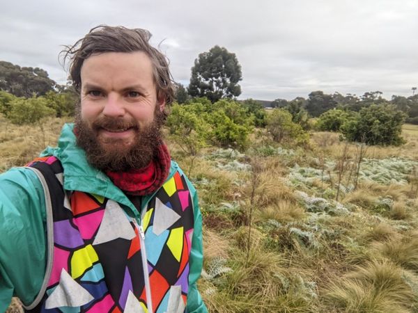
Success
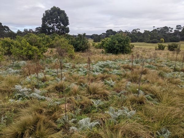
Long wet grass
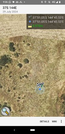
GPS proof


Achievements
John earned the Drowned Rat Geohash Achievement
|
Johnwrw earned the Bicycle geohash achievement
|