Difference between revisions of "2024-07-29 58 5"
From Geohashing
([live picture]SAND ES [https://openstreetmap.org/?mlat=58.85084610&mlon=5.75882820&zoom=16 @58.8508,5.7588]) |
(→Achievements) |
||
| (12 intermediate revisions by the same user not shown) | |||
| Line 8: | Line 8: | ||
And DON'T FORGET to add your expedition and the best photo you took to the gallery on the Main Page! We'd love to read your report, but that means we first have to discover it! :) | And DON'T FORGET to add your expedition and the best photo you took to the gallery on the Main Page! We'd love to read your report, but that means we first have to discover it! :) | ||
-->{{meetup graticule|date=2024-07-29|lat=58|lon=5}} | -->{{meetup graticule|date=2024-07-29|lat=58|lon=5}} | ||
| + | |||
| + | [[Image:20240729 58 5 Me.jpg|thumb|left]] | ||
== Location == | == Location == | ||
<!-- where you've surveyed the hash to be --> | <!-- where you've surveyed the hash to be --> | ||
| + | |||
| + | On the mountain Skjeraberget in the Hana district, Sandnes, Norway | ||
== Participants == | == Participants == | ||
<!-- who attended: If you link to your wiki user name in this section, your expedition will be picked up by the various statistics generated for geohashing. You may use three tildes ~ as a shortcut to automatically insert the user signature of the account you are editing with. | <!-- who attended: If you link to your wiki user name in this section, your expedition will be picked up by the various statistics generated for geohashing. You may use three tildes ~ as a shortcut to automatically insert the user signature of the account you are editing with. | ||
--> | --> | ||
| + | |||
| + | *[[User:Pica42|Pica42]] | ||
| + | * pica42's wife | ||
== Plans == | == Plans == | ||
| Line 20: | Line 27: | ||
== Expedition == | == Expedition == | ||
<!-- how it all turned out. your narrative goes here. --> | <!-- how it all turned out. your narrative goes here. --> | ||
| + | |||
| + | Today I had forgotten that I planned to find a Geohash. Fortunately, my wife has a better memory than I do. The trip was about 13 km by car, then a little more than a hundred meters to walk. Not far from ground zero is a sign with a wolf. | ||
== Tracklog == | == Tracklog == | ||
| Line 32: | Line 41: | ||
Image:2024-07-29_58_5_Pica42_1722241494458.jpg|Sandnes [https://openstreetmap.org/?mlat=58.85085710&mlon=5.75884630&zoom=16 @58.8509,5.7588] | Image:2024-07-29_58_5_Pica42_1722241494458.jpg|Sandnes [https://openstreetmap.org/?mlat=58.85085710&mlon=5.75884630&zoom=16 @58.8509,5.7588] | ||
| − | Image:2024-07-29_58_5_Pica42_1722241596247.jpg| | + | Image:2024-07-29_58_5_Pica42_1722241596247.jpg|Sandnes [https://openstreetmap.org/?mlat=58.85084610&mlon=5.75882820&zoom=16 @58.8508,5.7588] |
| + | Image:20240729 58 5 NW.jpg|thumb|View to the northwest | ||
| + | Image:20240729 58 5 SW.jpg|thumb|View to the southwest | ||
| + | Image:20240729 58 5 SE.jpg|thumb|View to the southeast | ||
| + | Image:20240729 58 5 NE.jpg|thumb|View to the northeast | ||
| + | Image:20240729 58 5 Ulv.jpg|thumb|Wolf | ||
</gallery> | </gallery> | ||
| Line 39: | Line 53: | ||
<!-- Add any achievement ribbons you earned below, or remove this section --> | <!-- Add any achievement ribbons you earned below, or remove this section --> | ||
| − | + | {{land geohash |name=[[User:Pica42|Pica42]] |date=2024-07-29 |latitude=58 |longitude=5 }} | |
| − | |||
| − | |||
| − | [[ | ||
| − | |||
| − | |||
| − | |||
| − | |||
| − | |||
| − | |||
| − | |||
[[Category:Expeditions]] | [[Category:Expeditions]] | ||
| − | |||
[[Category:Expeditions with photos]] | [[Category:Expeditions with photos]] | ||
| − | |||
| − | |||
| − | |||
| − | |||
[[Category:Coordinates reached]] | [[Category:Coordinates reached]] | ||
| + | {{location|NO|11}} | ||
| − | |||
| − | |||
| − | |||
| − | |||
| − | |||
| − | |||
| − | |||
| − | + | __NOTOC__ | |
| − | |||
| − | |||
| − | |||
Latest revision as of 15:55, 29 July 2024
| Mon 29 Jul 2024 in 58,5: 58.8508491, 5.7588332 geohashing.info google osm bing/os kml crox |

Location
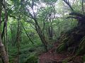
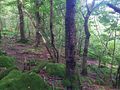
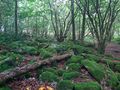
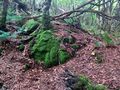
On the mountain Skjeraberget in the Hana district, Sandnes, Norway
Participants
- Pica42
- pica42's wife
Plans
Expedition
Today I had forgotten that I planned to find a Geohash. Fortunately, my wife has a better memory than I do. The trip was about 13 km by car, then a little more than a hundred meters to walk. Not far from ground zero is a sign with a wolf.
Tracklog
Photos

Sandnes @58.8509,5.7588

Sandnes @58.8508,5.7588
View to the northwest
View to the southwest
View to the southeast
View to the northeast
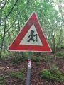
Wolf


Achievements
Pica42 earned the Land geohash achievement
|