Difference between revisions of "2024-07-29 58 5"
From Geohashing
(→Photos) |
(→Achievements) |
||
| (2 intermediate revisions by the same user not shown) | |||
| Line 27: | Line 27: | ||
== Expedition == | == Expedition == | ||
<!-- how it all turned out. your narrative goes here. --> | <!-- how it all turned out. your narrative goes here. --> | ||
| + | |||
| + | Today I had forgotten that I planned to find a Geohash. Fortunately, my wife has a better memory than I do. The trip was about 13 km by car, then a little more than a hundred meters to walk. Not far from ground zero is a sign with a wolf. | ||
== Tracklog == | == Tracklog == | ||
| Line 44: | Line 46: | ||
Image:20240729 58 5 SE.jpg|thumb|View to the southeast | Image:20240729 58 5 SE.jpg|thumb|View to the southeast | ||
Image:20240729 58 5 NE.jpg|thumb|View to the northeast | Image:20240729 58 5 NE.jpg|thumb|View to the northeast | ||
| − | + | Image:20240729 58 5 Ulv.jpg|thumb|Wolf | |
</gallery> | </gallery> | ||
| Line 51: | Line 53: | ||
<!-- Add any achievement ribbons you earned below, or remove this section --> | <!-- Add any achievement ribbons you earned below, or remove this section --> | ||
| − | + | {{land geohash |name=[[User:Pica42|Pica42]] |date=2024-07-29 |latitude=58 |longitude=5 }} | |
| − | |||
| − | |||
| − | [[ | ||
| − | |||
| − | |||
| − | |||
| − | |||
| − | |||
| − | |||
| − | |||
[[Category:Expeditions]] | [[Category:Expeditions]] | ||
| − | |||
[[Category:Expeditions with photos]] | [[Category:Expeditions with photos]] | ||
| − | |||
| − | |||
| − | |||
| − | |||
[[Category:Coordinates reached]] | [[Category:Coordinates reached]] | ||
| + | {{location|NO|11}} | ||
| − | |||
| − | |||
| − | |||
| − | |||
| − | |||
| − | |||
| − | |||
| − | + | __NOTOC__ | |
| − | |||
| − | |||
| − | |||
Latest revision as of 15:55, 29 July 2024
| Mon 29 Jul 2024 in 58,5: 58.8508491, 5.7588332 geohashing.info google osm bing/os kml crox |

Location
On the mountain Skjeraberget in the Hana district, Sandnes, Norway
Participants
- Pica42
- pica42's wife
Plans
Expedition
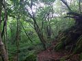
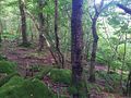
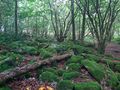
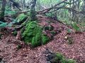
Today I had forgotten that I planned to find a Geohash. Fortunately, my wife has a better memory than I do. The trip was about 13 km by car, then a little more than a hundred meters to walk. Not far from ground zero is a sign with a wolf.
Tracklog
Photos

Sandnes @58.8509,5.7588

Sandnes @58.8508,5.7588
View to the northwest
View to the southwest
View to the southeast
View to the northeast
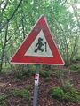
Wolf


Achievements
Pica42 earned the Land geohash achievement
|