Difference between revisions of "2024-08-01 47 -122"
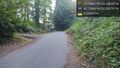
([live picture]Sideways again, hrmmph. West of hash point. [https://openstreetmap.org/?mlat=47.72941500&mlon=-122.32743700&zoom=16 @47.7294,-122.3274]) |
|||
| (6 intermediate revisions by the same user not shown) | |||
| Line 1: | Line 1: | ||
| − | + | {{meetup graticule|date=2024-08-01|lat=47|lon=-122 | |
| − | + | | graticule_name=Seattle | |
| − | + | | graticule_link=Seattle, Washington }} | |
| − | |||
| − | |||
| − | |||
| − | |||
| − | |||
| − | |||
== Location == | == Location == | ||
| − | + | North Seattle neighborhood, at the Y between two diverging streets. | |
== Participants == | == Participants == | ||
| − | + | * [[User:Thomcat|Thomcat]] | |
| − | |||
== Plans == | == Plans == | ||
| − | + | Stop by when back in town | |
== Expedition == | == Expedition == | ||
| − | < | + | I've been on vacation in north eastern Washington, with inaccessible hashpoints around me (< 20km) each day. I noted this point was a possibility before beginning my 500km return trip on Thursday morning. |
| + | |||
| + | The two dimensional top down map made this look like a gentle break between two roads; the aerial view showed some foliage. A simple tree to duck under perhaps? The neighborhood is near some construction, and quite close to Interstate 5. There is a concrete sound barrier wall, but it is wholly insufficient to mask Thursday late rush hour traffic noise. | ||
| + | |||
| + | What was 2D on the map was a relatively steep downhill in person. The battered sign showing the two streets seemed backwards to me - perhaps confusing to delivery drivers. What looked like foliage was a tree and a whole lot of sticker-guarded berries below. I wondered if I could lean in close, but rarely got below 5 meters distant. Mother nature... | ||
| + | |||
| + | Just south of the point is Lakeside middle school, and just north Lakeside high school, the alma mater of a certain Redmond based billionaire. | ||
== Tracklog == | == Tracklog == | ||
| Line 31: | Line 30: | ||
Image:2024-08-01_47_-122_thomcat_1722565344793.jpg|Sideways again, hrmmph. West of hash point. [https://openstreetmap.org/?mlat=47.72941500&mlon=-122.32743700&zoom=16 @47.7294,-122.3274] | Image:2024-08-01_47_-122_thomcat_1722565344793.jpg|Sideways again, hrmmph. West of hash point. [https://openstreetmap.org/?mlat=47.72941500&mlon=-122.32743700&zoom=16 @47.7294,-122.3274] | ||
| + | |||
| + | Image:2024-08-01_47_-122_thomcat_1722565420948.jpg|Bet this confuses delivery drivers... [https://openstreetmap.org/?mlat=47.72958100&mlon=-122.32709697&zoom=16 @47.7296,-122.3271] | ||
| + | |||
| + | Image:2024-08-01_47_-122_thomcat_1722565510907.jpg|Stickers & berries [https://openstreetmap.org/?mlat=47.72964400&mlon=-122.32680797&zoom=16 @47.7296,-122.3268] | ||
| + | |||
| + | Image:2024-08-01_47_-122_thomcat_1722565602820.jpg|Geohasher [https://openstreetmap.org/?mlat=47.72962700&mlon=-122.32678400&zoom=16 @47.7296,-122.3268] | ||
| + | |||
| + | Image:2024-08-01_47_-122_thomcat_1722565627244.jpg|View east, towards freeway [https://openstreetmap.org/?mlat=47.72962400&mlon=-122.32678797&zoom=16 @47.7296,-122.3268] | ||
| + | |||
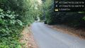
| + | Image:2024-08-01_47_-122_thomcat_1722565690001.jpg|View west / up hill, to hashcar [https://openstreetmap.org/?mlat=47.72962400&mlon=-122.32678797&zoom=16 @47.7296,-122.3268] | ||
| + | |||
| + | Image:2024-08-01_47_-122_thomcat_1722565907493.jpg|Nearby school [https://openstreetmap.org/?mlat=47.73177400&mlon=-122.32882100&zoom=16 @47.7318,-122.3288] | ||
</gallery> | </gallery> | ||
| Line 38: | Line 49: | ||
__NOTOC__ | __NOTOC__ | ||
| − | |||
| − | |||
| − | |||
| − | |||
| − | |||
| − | |||
| − | |||
| − | |||
| − | |||
| − | |||
[[Category:Expeditions]] | [[Category:Expeditions]] | ||
| − | |||
[[Category:Expeditions with photos]] | [[Category:Expeditions with photos]] | ||
| − | |||
| − | |||
| − | |||
| − | |||
| − | |||
| − | |||
[[Category:Coordinates not reached]] | [[Category:Coordinates not reached]] | ||
| − | |||
| − | |||
[[Category:Not reached - Mother Nature]] | [[Category:Not reached - Mother Nature]] | ||
| − | + | {{location|US|WA|KN}} | |
| − | |||
| − | |||
| − | |||
| − | |||
| − | |||
| − | |||
| − | |||
Latest revision as of 17:12, 2 August 2024
| Thu 1 Aug 2024 in Seattle: 47.7296678, -122.3267523 geohashing.info google osm bing/os kml crox |
Location
North Seattle neighborhood, at the Y between two diverging streets.
Participants
Plans
Stop by when back in town
Expedition
I've been on vacation in north eastern Washington, with inaccessible hashpoints around me (< 20km) each day. I noted this point was a possibility before beginning my 500km return trip on Thursday morning.
The two dimensional top down map made this look like a gentle break between two roads; the aerial view showed some foliage. A simple tree to duck under perhaps? The neighborhood is near some construction, and quite close to Interstate 5. There is a concrete sound barrier wall, but it is wholly insufficient to mask Thursday late rush hour traffic noise.
What was 2D on the map was a relatively steep downhill in person. The battered sign showing the two streets seemed backwards to me - perhaps confusing to delivery drivers. What looked like foliage was a tree and a whole lot of sticker-guarded berries below. I wondered if I could lean in close, but rarely got below 5 meters distant. Mother nature...
Just south of the point is Lakeside middle school, and just north Lakeside high school, the alma mater of a certain Redmond based billionaire.
Tracklog
Photos
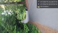
Sideways again, hrmmph. West of hash point. @47.7294,-122.3274
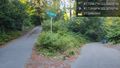
Bet this confuses delivery drivers... @47.7296,-122.3271
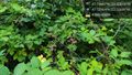
Stickers & berries @47.7296,-122.3268

Geohasher @47.7296,-122.3268
View east, towards freeway @47.7296,-122.3268
View west / up hill, to hashcar @47.7296,-122.3268

Nearby school @47.7318,-122.3288


