Difference between revisions of "2024-08-05 58 5"
From Geohashing
(An expedition message sent via Geohash Droid for Android.) |
(→Tracklog) |
||
| (15 intermediate revisions by the same user not shown) | |||
| Line 8: | Line 8: | ||
And DON'T FORGET to add your expedition and the best photo you took to the gallery on the Main Page! We'd love to read your report, but that means we first have to discover it! :) | And DON'T FORGET to add your expedition and the best photo you took to the gallery on the Main Page! We'd love to read your report, but that means we first have to discover it! :) | ||
-->{{meetup graticule|date=2024-08-05|lat=58|lon=5}} | -->{{meetup graticule|date=2024-08-05|lat=58|lon=5}} | ||
| + | |||
| + | [[Image:20240805_58 5 Me.jpg|thumb|left]] | ||
== Location == | == Location == | ||
<!-- where you've surveyed the hash to be --> | <!-- where you've surveyed the hash to be --> | ||
| + | |||
| + | In a mountain pasture for sheeps and cows at Myrland, Sandnes, Norway. | ||
== Participants == | == Participants == | ||
<!-- who attended: If you link to your wiki user name in this section, your expedition will be picked up by the various statistics generated for geohashing. You may use three tildes ~ as a shortcut to automatically insert the user signature of the account you are editing with. | <!-- who attended: If you link to your wiki user name in this section, your expedition will be picked up by the various statistics generated for geohashing. You may use three tildes ~ as a shortcut to automatically insert the user signature of the account you are editing with. | ||
--> | --> | ||
| + | |||
| + | *[[User:Pica42|Pica42]] | ||
== Plans == | == Plans == | ||
| Line 20: | Line 26: | ||
== Expedition == | == Expedition == | ||
<!-- how it all turned out. your narrative goes here. --> | <!-- how it all turned out. your narrative goes here. --> | ||
| + | |||
| + | On this day I was unsure if the weather would be good enough to find a hash point, it was. In addition to the geohash, I also found three geocaches in the area. | ||
== Tracklog == | == Tracklog == | ||
<!-- if your GPS device keeps a log, you may use Template:Tracklog, post a link here, or both --> | <!-- if your GPS device keeps a log, you may use Template:Tracklog, post a link here, or both --> | ||
| + | |||
| + | {{tracklog |Activity 16678922467.gpx}} | ||
== Photos == | == Photos == | ||
| Line 29: | Line 39: | ||
--> | --> | ||
<gallery perrow="5"> | <gallery perrow="5"> | ||
| + | |||
| + | Image:2024-08-05_58_5_Pica42_1722846157868.jpg|Myrland [https://openstreetmap.org/?mlat=58.92003660&mlon=5.91971690&zoom=16 @58.9200,5.9197] | ||
| + | Image:20240805 58 5 NE.jpg|thumb|View to the northeast | ||
| + | Image:20240805 58 5 NW.jpg|thumb|View to the northwest | ||
| + | Image:20240805 58 5 SW.jpg|thumb|View to the southwest | ||
| + | Image:20240805 58 5 SE.jpg|thumb|View to the southeast | ||
</gallery> | </gallery> | ||
| Line 35: | Line 51: | ||
<!-- Add any achievement ribbons you earned below, or remove this section --> | <!-- Add any achievement ribbons you earned below, or remove this section --> | ||
| − | + | {{land geohash |name=[[User:Pica42|Pica42]] |date=2024-08-05 |latitude=58 |longitude=5 }} | |
| − | |||
| − | |||
| − | [[ | ||
| − | |||
| − | |||
| − | |||
| − | |||
| − | |||
| − | |||
| − | |||
[[Category:Expeditions]] | [[Category:Expeditions]] | ||
| − | |||
[[Category:Expeditions with photos]] | [[Category:Expeditions with photos]] | ||
| − | |||
| − | |||
| − | |||
| − | |||
[[Category:Coordinates reached]] | [[Category:Coordinates reached]] | ||
| + | {{location|NO|11}} | ||
| − | |||
| − | |||
| − | |||
| − | |||
| − | |||
| − | + | __NOTOC__ | |
| − | |||
| − | |||
| − | |||
| − | |||
| − | |||
| − | |||
Latest revision as of 14:57, 9 August 2024
| Mon 5 Aug 2024 in 58,5: 58.9200070, 5.9197153 geohashing.info google osm bing/os kml crox |

Location
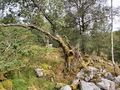
In a mountain pasture for sheeps and cows at Myrland, Sandnes, Norway.
Participants
Plans
Expedition
On this day I was unsure if the weather would be good enough to find a hash point, it was. In addition to the geohash, I also found three geocaches in the area.
Tracklog
Photos

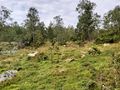
Myrland @58.9200,5.9197
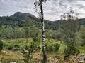
View to the northeast
View to the northwest
View to the southwest
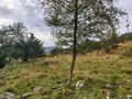
View to the southeast


Achievements
Pica42 earned the Land geohash achievement
|