Difference between revisions of "2024-08-09 51 6"
Coyotebush (talk | contribs) ([live picture]never mind about the creek path [https://openstreetmap.org/?mlat=51.48701111&mlon=6.97999167&zoom=16 @51.4870,6.9800]) |
m (Location) |
||
| (7 intermediate revisions by one other user not shown) | |||
| Line 21: | Line 21: | ||
*Transferring at Oberhausen. ETA 13:00 unless I stop for lunch first. -- [[User:Coyotebush|Coyotebush]] ([[User talk:Coyotebush|talk]]) [https://openstreetmap.org/?mlat=51.47465118&mlon=6.85206669&zoom=16 @51.4747,6.8521] 12:32, 9 August 2024 (GMT+02:00) | *Transferring at Oberhausen. ETA 13:00 unless I stop for lunch first. -- [[User:Coyotebush|Coyotebush]] ([[User talk:Coyotebush|talk]]) [https://openstreetmap.org/?mlat=51.47465118&mlon=6.85206669&zoom=16 @51.4747,6.8521] 12:32, 9 August 2024 (GMT+02:00) | ||
| + | |||
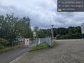
| + | I biked from the Bergeborbeck station. Garmin routed me straight up Hafenstraße, while Google suggested possibly using the path along the creek. Hafenstraße had a bike lane to start, but that disappeared at the first intersection and the ride got more stressful. I located the creek path and found it thoroughly closed - oh well. | ||
| + | |||
| + | I turned onto, then crossed, Vogelheimer Straße and entered the park. Garmin led me on the paths right to the point - no walking needed. | ||
| + | |||
| + | Now I was definitely hungry, so I returned to Vogelheimer Straße and found a döner shop. Soon after I ordered, it started raining, and the very friendly shopkeeper offered to let me move my bike into the building hallway. By the time I finished eating, it was mostly dry out again. | ||
| + | |||
| + | I tried another Google-suggested back route that could have also led to Altenessen for a wider selection of trains, but this also hit a closure, so I had to go down Hafenstraße to the Bergeborbeck station again. | ||
| + | |||
== Photos == | == Photos == | ||
<!-- | <!-- | ||
| Line 29: | Line 38: | ||
Image:2024-08-09_51_6_coyotebush_1723202963923.jpg|never mind about the creek path [https://openstreetmap.org/?mlat=51.48701111&mlon=6.97999167&zoom=16 @51.4870,6.9800] | Image:2024-08-09_51_6_coyotebush_1723202963923.jpg|never mind about the creek path [https://openstreetmap.org/?mlat=51.48701111&mlon=6.97999167&zoom=16 @51.4870,6.9800] | ||
| + | |||
| + | Image:2024-08-09_51_6_coyotebush_1723203017991.jpg|reached by bike [https://openstreetmap.org/?mlat=51.49179444&mlon=6.98803889&zoom=16 @51.4918,6.9880] | ||
| + | |||
| + | Image:2024-08-09_51_6_coyotebush_1723203028668.jpg|grin [https://openstreetmap.org/?mlat=51.49178056&mlon=6.98798056&zoom=16 @51.4918,6.9880] | ||
| + | |||
| + | Image:2024-08-09_51_6_coyotebush_1723203047717.jpg|map screenshot | ||
| + | |||
| + | Image:2024-08-09_51_6_coyotebush_1723203775484.jpg|Döner in the rain [https://openstreetmap.org/?mlat=51.49083271&mlon=6.98932060&zoom=16 @51.4908,6.9893] | ||
| + | |||
| + | Image:2024-08-09_51_6_coyotebush_1723206742018.jpg|no access here either [https://openstreetmap.org/?mlat=51.48810556&mlon=6.98519722&zoom=16 @51.4881,6.9852] | ||
</gallery> | </gallery> | ||
| − | |||
| − | |||
__NOTOC__ | __NOTOC__ | ||
| − | |||
| − | |||
| − | |||
[[Category:Expeditions]] | [[Category:Expeditions]] | ||
| Line 45: | Line 59: | ||
[[Category:Coordinates reached]] | [[Category:Coordinates reached]] | ||
| − | + | {{location|DE|NW|E}} | |
| − | |||
| − | |||
| − | |||
| − | |||
| − | |||
| − | |||
| − | |||
Latest revision as of 17:43, 19 August 2024
| Fri 9 Aug 2024 in 51,6: 51.4918039, 6.9879966 geohashing.info google osm bing/os kml crox |
Location
A park in the Vogelheim district of Essen.
Participants
Plans
Train to nearby station Bergeborbeck or Altenessen, then bike.
Expedition
- Transferring at Oberhausen. ETA 13:00 unless I stop for lunch first. -- Coyotebush (talk) @51.4747,6.8521 12:32, 9 August 2024 (GMT+02:00)
I biked from the Bergeborbeck station. Garmin routed me straight up Hafenstraße, while Google suggested possibly using the path along the creek. Hafenstraße had a bike lane to start, but that disappeared at the first intersection and the ride got more stressful. I located the creek path and found it thoroughly closed - oh well.
I turned onto, then crossed, Vogelheimer Straße and entered the park. Garmin led me on the paths right to the point - no walking needed.
Now I was definitely hungry, so I returned to Vogelheimer Straße and found a döner shop. Soon after I ordered, it started raining, and the very friendly shopkeeper offered to let me move my bike into the building hallway. By the time I finished eating, it was mostly dry out again.
I tried another Google-suggested back route that could have also led to Altenessen for a wider selection of trains, but this also hit a closure, so I had to go down Hafenstraße to the Bergeborbeck station again.
Photos
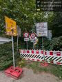
never mind about the creek path @51.4870,6.9800
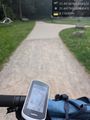
reached by bike @51.4918,6.9880
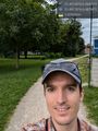
grin @51.4918,6.9880
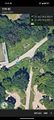
map screenshot
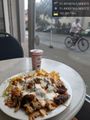
Döner in the rain @51.4908,6.9893
no access here either @51.4881,6.9852


