Difference between revisions of "2024-08-05 58 5"
From Geohashing
(→Photos) |
(→Tracklog) |
||
| (2 intermediate revisions by the same user not shown) | |||
| Line 31: | Line 31: | ||
== Tracklog == | == Tracklog == | ||
<!-- if your GPS device keeps a log, you may use Template:Tracklog, post a link here, or both --> | <!-- if your GPS device keeps a log, you may use Template:Tracklog, post a link here, or both --> | ||
| + | |||
| + | {{tracklog |Activity 16678922467.gpx}} | ||
== Photos == | == Photos == | ||
| Line 41: | Line 43: | ||
Image:20240805 58 5 NE.jpg|thumb|View to the northeast | Image:20240805 58 5 NE.jpg|thumb|View to the northeast | ||
Image:20240805 58 5 NW.jpg|thumb|View to the northwest | Image:20240805 58 5 NW.jpg|thumb|View to the northwest | ||
| − | + | Image:20240805 58 5 SW.jpg|thumb|View to the southwest | |
| − | + | Image:20240805 58 5 SE.jpg|thumb|View to the southeast | |
</gallery> | </gallery> | ||
Latest revision as of 14:57, 9 August 2024
| Mon 5 Aug 2024 in 58,5: 58.9200070, 5.9197153 geohashing.info google osm bing/os kml crox |

Location
In a mountain pasture for sheeps and cows at Myrland, Sandnes, Norway.
Participants
Plans
Expedition
On this day I was unsure if the weather would be good enough to find a hash point, it was. In addition to the geohash, I also found three geocaches in the area.
Tracklog
Photos

Myrland @58.9200,5.9197
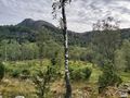
View to the northeast
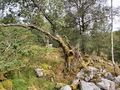
View to the northwest
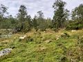
View to the southwest
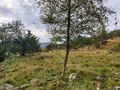
View to the southeast


Achievements
Pica42 earned the Land geohash achievement
|