Difference between revisions of "2024-08-16 58 5"
From Geohashing
(→Expedition) |
|||
| (7 intermediate revisions by the same user not shown) | |||
| Line 27: | Line 27: | ||
== Expedition == | == Expedition == | ||
<!-- how it all turned out. your narrative goes here. --> | <!-- how it all turned out. your narrative goes here. --> | ||
| + | |||
| + | This was a nice trip among cows and sheep. The hash point was in a grazing area and was easy to get to. | ||
== Tracklog == | == Tracklog == | ||
| Line 38: | Line 40: | ||
Image:2024-08-16_58_5_Pica42_1723801335416.jpg|Sviland [https://openstreetmap.org/?mlat=58.82838110&mlon=5.80412940&zoom=16 @58.8284,5.8041] | Image:2024-08-16_58_5_Pica42_1723801335416.jpg|Sviland [https://openstreetmap.org/?mlat=58.82838110&mlon=5.80412940&zoom=16 @58.8284,5.8041] | ||
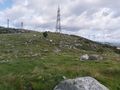
| − | + | Image:20240816 58 5 N.jpg|thumb|View to the north | |
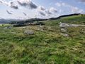
| + | Image:20240816 58 5 W.jpg|thumb|View to the west | ||
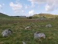
| + | Image:20240816 58 5 S.jpg|thumb|View to the south | ||
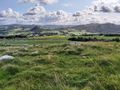
| + | Image:20240816 58 5 E.jpg|thumb|View to the east | ||
| + | Image:20240816 58 5 Friends.jpg|thumb|Friends | ||
</gallery> | </gallery> | ||
| Line 45: | Line 51: | ||
<!-- Add any achievement ribbons you earned below, or remove this section --> | <!-- Add any achievement ribbons you earned below, or remove this section --> | ||
| − | + | {{land geohash |name=[[User:Pica42|Pica42]] |date=2024-08-16 |latitude=58 |longitude=5 }} | |
| − | |||
| − | |||
| − | [[ | ||
| − | |||
| − | |||
| − | |||
| − | |||
| − | |||
| − | |||
| − | |||
[[Category:Expeditions]] | [[Category:Expeditions]] | ||
| − | |||
[[Category:Expeditions with photos]] | [[Category:Expeditions with photos]] | ||
| − | |||
| − | |||
| − | |||
| − | |||
[[Category:Coordinates reached]] | [[Category:Coordinates reached]] | ||
| + | {{location|NO|11}} | ||
| − | |||
| − | |||
| − | |||
| − | |||
| − | |||
| − | |||
| − | |||
| − | + | __NOTOC__ | |
| − | |||
| − | |||
| − | |||
Latest revision as of 16:21, 22 August 2024
| Fri 16 Aug 2024 in 58,5: 58.8284010, 5.8041823 geohashing.info google osm bing/os kml crox |

Location
Vindberget, Sviland, Sandnes, Norway
Participants
Plans
Expedition
This was a nice trip among cows and sheep. The hash point was in a grazing area and was easy to get to.
Tracklog
Photos

Sviland @58.8284,5.8041
View to the north
View to the west
View to the south
View to the east
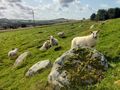
Friends


Achievements
Pica42 earned the Land geohash achievement
|