Difference between revisions of "2024-08-20 52 5"
MyrtleGlacy (talk | contribs) |
m (Location) |
||
| (9 intermediate revisions by 3 users not shown) | |||
| Line 1: | Line 1: | ||
| − | + | {{meetup graticule|date=2024-08-20|lat=52|lon=5}} | |
| − | |||
| − | |||
| − | |||
| − | |||
| − | |||
| − | |||
| − | |||
| − | |||
== Location == | == Location == | ||
In the paleispark Het Loo. | In the paleispark Het Loo. | ||
== Participants == | == Participants == | ||
| + | *[[User:coyotebush|coyotebush]] | ||
*[[User:MyrtleGlacy|MyrtleGlacy]] | *[[User:MyrtleGlacy|MyrtleGlacy]] | ||
== Plans == | == Plans == | ||
| + | ===coyotebush=== | ||
| + | Maybe visit before catching an IC train to Germany. | ||
| + | ===MyrtleGlacy=== | ||
| + | Pointed out the interesting location, saw coyotebush's experience. | ||
== Expedition == | == Expedition == | ||
| − | + | ===coyotebush=== | |
| + | I started my day's travels an hour early, giving me that much time in Apeldoorn - hopefully enough to bike to the hash and back plus grab some food. From the station I biked north, avoiding pedestrian areas Garmin suggested but failing to avoid bumpy brick roads. Google Maps made it look like I could navigate up the road just west of the point, so I entered that way, after also seeing a closed bike path and missing the east parking lot entrance. The road was narrow for two-way traffic, and soon it was clear that nothing actually intersected it from the east. So I walked into the forest, finding plenty of blackberry vines in the undergrowth. Unfortunately, before I reached the point, a fence topped with barbed wire appeared. | ||
| + | |||
| + | I shared these findings with MyrtleGlacy then started to retrace my route, watching the fence through the trees. When I saw other cyclists using the bike entrance to the parking lot, I decided to follow and see if there was an entrance. There was a map posted which clearly showed the fence to the west and south of the point. It was also very clear that entry with a bicycle was forbidden, though I didn't notice that a fee would have also been required. Walking 1km each way would have made me very late to [[2024-08-20 52 8|52 8]], so I headed back to the station. This was much easier to navigate via wayfinding signs. Even had a few minutes to buy a prepackaged wrap before catching the IC train. | ||
| + | |||
| + | ===MyrtleGlacy=== | ||
| + | Sent an e-mail to office of the palace to check whether the park was open. Got on the train when they told me it was. Bought a 2 euro ticket. Walked onto a path that wasn't a path, and got the hash. More info to come. | ||
== Tracklog == | == Tracklog == | ||
| − | + | coyotebush's bike: | |
| + | |||
| + | {{tracklog|2024-08-20 52 5 coyotebush bike.gpx}} | ||
== Photos == | == Photos == | ||
| Line 29: | Line 34: | ||
--> | --> | ||
<gallery perrow="5"> | <gallery perrow="5"> | ||
| + | |||
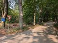
| + | Image:2024-08-20_52_5_coyotebush_1724262543077.jpg|entrance to small road | ||
| + | |||
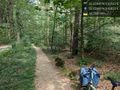
| + | Image:2024-08-20_52_5_coyotebush_1724262580245.jpg|bike parked [https://openstreetmap.org/?mlat=52.22889444&mlon=5.92875000&zoom=16 @52.2289,5.9288] | ||
Image:2024-08-20_52_5_coyotebush_1724148866516.jpg|Fence hidden by blackberries [https://openstreetmap.org/?mlat=52.22899167&mlon=5.92894722&zoom=16 @52.2290,5.9289] | Image:2024-08-20_52_5_coyotebush_1724148866516.jpg|Fence hidden by blackberries [https://openstreetmap.org/?mlat=52.22899167&mlon=5.92894722&zoom=16 @52.2290,5.9289] | ||
| + | |||
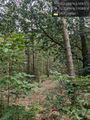
| + | Image:2024-08-20_52_5_coyotebush_1724154505911.jpg|Closest approach from the west | ||
Image:2024-08-20_52_5_coyotebush_1724150048291.jpg|Map at parking lot [https://openstreetmap.org/?mlat=52.22887500&mlon=5.94189444&zoom=16 @52.2289,5.9419] | Image:2024-08-20_52_5_coyotebush_1724150048291.jpg|Map at parking lot [https://openstreetmap.org/?mlat=52.22887500&mlon=5.94189444&zoom=16 @52.2289,5.9419] | ||
| − | |||
</gallery> | </gallery> | ||
| Line 46: | Line 56: | ||
</gallery> | </gallery> | ||
| + | |||
== Achievements == | == Achievements == | ||
{{#vardefine:ribbonwidth|100%}} | {{#vardefine:ribbonwidth|100%}} | ||
<!-- Add any achievement ribbons you earned below, or remove this section --> | <!-- Add any achievement ribbons you earned below, or remove this section --> | ||
| + | {{White Rabbit | latitude = 52 | longitude = 5 | date = 2024-08-20 | name = coyotebush }} | ||
| + | {{Admit One geohash | latitude = 52 | longitude = 5 | date = 2024-08-20 | price = €2 | venue = Het Loo Palace | name = MyrtleGlacy }} | ||
__NOTOC__ | __NOTOC__ | ||
| − | |||
| − | |||
| − | |||
| − | |||
| − | |||
| − | |||
| − | |||
| − | |||
| − | |||
| − | |||
[[Category:Expeditions]] | [[Category:Expeditions]] | ||
| − | |||
[[Category:Expeditions with photos]] | [[Category:Expeditions with photos]] | ||
| − | |||
| − | |||
| − | |||
| − | |||
[[Category:Coordinates reached]] | [[Category:Coordinates reached]] | ||
| − | + | {{location|NL|GE}} | |
| − | |||
| − | |||
| − | |||
| − | |||
| − | |||
| − | |||
| − | |||
| − | |||
| − | |||
| − | |||
| − | |||
| − | |||
| − | |||
Latest revision as of 07:43, 22 August 2024
| Tue 20 Aug 2024 in 52,5: 52.2288004, 5.9292350 geohashing.info google osm bing/os kml crox |
Location
In the paleispark Het Loo.
Participants
Plans
coyotebush
Maybe visit before catching an IC train to Germany.
MyrtleGlacy
Pointed out the interesting location, saw coyotebush's experience.
Expedition
coyotebush
I started my day's travels an hour early, giving me that much time in Apeldoorn - hopefully enough to bike to the hash and back plus grab some food. From the station I biked north, avoiding pedestrian areas Garmin suggested but failing to avoid bumpy brick roads. Google Maps made it look like I could navigate up the road just west of the point, so I entered that way, after also seeing a closed bike path and missing the east parking lot entrance. The road was narrow for two-way traffic, and soon it was clear that nothing actually intersected it from the east. So I walked into the forest, finding plenty of blackberry vines in the undergrowth. Unfortunately, before I reached the point, a fence topped with barbed wire appeared.
I shared these findings with MyrtleGlacy then started to retrace my route, watching the fence through the trees. When I saw other cyclists using the bike entrance to the parking lot, I decided to follow and see if there was an entrance. There was a map posted which clearly showed the fence to the west and south of the point. It was also very clear that entry with a bicycle was forbidden, though I didn't notice that a fee would have also been required. Walking 1km each way would have made me very late to 52 8, so I headed back to the station. This was much easier to navigate via wayfinding signs. Even had a few minutes to buy a prepackaged wrap before catching the IC train.
MyrtleGlacy
Sent an e-mail to office of the palace to check whether the park was open. Got on the train when they told me it was. Bought a 2 euro ticket. Walked onto a path that wasn't a path, and got the hash. More info to come.
Tracklog
coyotebush's bike:
Photos
coyotebush
entrance to small road
bike parked @52.2289,5.9288
Fence hidden by blackberries @52.2290,5.9289
Closest approach from the west
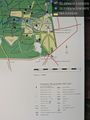
Map at parking lot @52.2289,5.9419


MyrtleGlacy
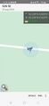
made it!
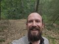
Happy face :)
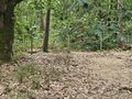
The east side of the fence


Achievements
coyotebush earned the White Rabbit consolation prize
|
MyrtleGlacy earned the Admit One Achievement
|