Difference between revisions of "2024-08-27 53 9"
From Geohashing
Coyotebush (talk | contribs) ([live picture]bicycles [https://openstreetmap.org/?mlat=53.93253611&mlon=9.78353611&zoom=16 @53.9325,9.7835]) |
m (Location) |
||
| (2 intermediate revisions by one other user not shown) | |||
| Line 18: | Line 18: | ||
== Expedition == | == Expedition == | ||
| + | === coyotebush === | ||
| + | Regional express train to Wrist, scheduled arrival 15:57, actual 16:00. Constant traffic on the Hauptstraße meant nobody was able to leave the station until the crossing gates closed for the next train. I took the bike path on the south side of the road, then had to cross the road for the final turns to the point. There I found π π π and his bike already waiting. | ||
| + | |||
| + | Quick dance around some trees and blackberry bushes, which I thankfully didn't have to step into. We chatted about travel for a short time, then biked out to the main road together and parted ways. I retraced my route to catch a 16:59 train back south. | ||
| Line 30: | Line 34: | ||
Image:2024-08-27_53_9_coyotebush_1724771430950.jpg|bicycles [https://openstreetmap.org/?mlat=53.93253611&mlon=9.78353611&zoom=16 @53.9325,9.7835] | Image:2024-08-27_53_9_coyotebush_1724771430950.jpg|bicycles [https://openstreetmap.org/?mlat=53.93253611&mlon=9.78353611&zoom=16 @53.9325,9.7835] | ||
| + | |||
| + | Image:2024-08-27_53_9_coyotebush_1724776413664.jpg|hashers [https://openstreetmap.org/?mlat=53.93253611&mlon=9.78353611&zoom=16 @53.9325,9.7835] | ||
</gallery> | </gallery> | ||
| Line 35: | Line 41: | ||
== Achievements == | == Achievements == | ||
{{#vardefine:ribbonwidth|100%}} | {{#vardefine:ribbonwidth|100%}} | ||
| + | {{meet-up|date=2024-08-27|latitude=53|longitude=9|name=[[User:coyotebush|coyotebush]] and [[User:π π π|π π π]]|other=each other|image=2024-08-27 53 9 coyotebush 1724776413664.jpg}} | ||
__NOTOC__ | __NOTOC__ | ||
| − | |||
| − | |||
| − | |||
| − | |||
[[Category:Expeditions]] | [[Category:Expeditions]] | ||
| Line 46: | Line 49: | ||
[[Category:Coordinates reached]] | [[Category:Coordinates reached]] | ||
| − | + | {{location|DE|SH|SE}} | |
| − | |||
| − | |||
| − | |||
| − | |||
| − | |||
| − | |||
| − | |||
Latest revision as of 13:42, 29 August 2024
| Tue 27 Aug 2024 in 53,9: 53.9325065, 9.7836644 geohashing.info google osm bing/os kml crox |
Location
Corner of a field near Wrist.
Participants
Plans
Arrive 16:10 at the point.
Expedition
coyotebush
Regional express train to Wrist, scheduled arrival 15:57, actual 16:00. Constant traffic on the Hauptstraße meant nobody was able to leave the station until the crossing gates closed for the next train. I took the bike path on the south side of the road, then had to cross the road for the final turns to the point. There I found π π π and his bike already waiting.
Quick dance around some trees and blackberry bushes, which I thankfully didn't have to step into. We chatted about travel for a short time, then biked out to the main road together and parted ways. I retraced my route to catch a 16:59 train back south.
Photos
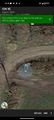
map screenshot
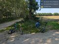
bicycles @53.9325,9.7835
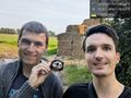
hashers @53.9325,9.7835


Achievements
coyotebush and π π π earned the Meet-up achievement
|