Difference between revisions of "2024-09-08 55 12"
Coyotebush (talk | contribs) |
m (Location) |
||
| (7 intermediate revisions by one other user not shown) | |||
| Line 16: | Line 16: | ||
== Expedition == | == Expedition == | ||
| + | I packed up early in Copenhagen and took a crowded A line S-train north from Østerport to Allerød. | ||
| + | From the station, I biked directly out the aptly named Tokkekøbvej to the forest entrance. Decided to follow Garmin's routing along more major trails, which was good because I didn't see evidence of OSM's purported trail directly west of the point. These trails were still fairly rough for Brompton wheels. A man with a dog sat down on a bench as I made a right turn onto a larger trail busy with runners and mountain bikes, but fortunately the corner was out of sight by the time I neared the point. | ||
| + | Walked into a clear part of the forest, adjusted by turning south, then re-emerged between two large trees to reach the point. | ||
| + | |||
| + | Biked back the same way, just in time to see a southbound train depart. So a 10-minute wait for the next one, and a short time to try to find food near the Copenhagen central station before boarding my train to Germany. | ||
| + | |||
| + | == Tracklog == | ||
| + | :{{square|00a}} Bike | ||
| + | :{{square|a00}} Foot | ||
| + | {{tracklog|2024-09-08 55 12 track.gpx}} | ||
== Photos == | == Photos == | ||
| Line 25: | Line 35: | ||
<gallery perrow="5"> | <gallery perrow="5"> | ||
| + | |||
| + | Image:2024-09-08_55_12_coyotebush_1725782875274.jpg|Grin [https://openstreetmap.org/?mlat=55.87759722&mlon=12.36766944&zoom=16 @55.8776,12.3677] | ||
| + | |||
| + | Image:2024-09-08_55_12_coyotebush_1725792399615.jpg|Tokkekøbvej | ||
| + | |||
| + | Image:2024-09-08_55_12_coyotebush_1725794062832.jpg|bike parked [https://openstreetmap.org/?mlat=55.87761667&mlon=12.36739722&zoom=16 @55.8776,12.3674] | ||
| + | |||
| + | Image:2024-09-08_55_12_coyotebush_1725794098323.jpg|looking the other way towards the point [https://openstreetmap.org/?mlat=55.87765000&mlon=12.36751389&zoom=16 @55.8776,12.3675] | ||
| + | |||
| + | Image:2024-09-08_55_12_coyotebush_1725794150033.jpg|map screenshot | ||
</gallery> | </gallery> | ||
| Line 32: | Line 52: | ||
__NOTOC__ | __NOTOC__ | ||
| − | |||
| − | |||
| − | |||
[[Category:Expeditions]] | [[Category:Expeditions]] | ||
| Line 41: | Line 58: | ||
[[Category:Coordinates reached]] | [[Category:Coordinates reached]] | ||
| − | + | {{location|DK|84}} | |
| − | |||
| − | |||
| − | |||
| − | |||
| − | |||
| − | |||
| − | |||
Latest revision as of 20:42, 17 September 2024
| Sun 8 Sep 2024 in 55,12: 55.8775949, 12.3676644 geohashing.info google osm bing/os kml crox |
Location
In the forest Tokkekøb Hegn.
Participants
Plans
Maybe visit in the morning.
Expedition
I packed up early in Copenhagen and took a crowded A line S-train north from Østerport to Allerød.
From the station, I biked directly out the aptly named Tokkekøbvej to the forest entrance. Decided to follow Garmin's routing along more major trails, which was good because I didn't see evidence of OSM's purported trail directly west of the point. These trails were still fairly rough for Brompton wheels. A man with a dog sat down on a bench as I made a right turn onto a larger trail busy with runners and mountain bikes, but fortunately the corner was out of sight by the time I neared the point.
Walked into a clear part of the forest, adjusted by turning south, then re-emerged between two large trees to reach the point.
Biked back the same way, just in time to see a southbound train depart. So a 10-minute wait for the next one, and a short time to try to find food near the Copenhagen central station before boarding my train to Germany.
Tracklog
- Bike
- Foot
Photos
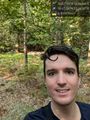
Grin @55.8776,12.3677
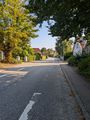
Tokkekøbvej
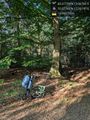
bike parked @55.8776,12.3674
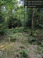
looking the other way towards the point @55.8776,12.3675
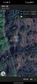
map screenshot


