Difference between revisions of "2024-09-08 64 25"
(Created page with "{{subst: expedition}}") |
m (Location) |
||
| (4 intermediate revisions by one other user not shown) | |||
| Line 1: | Line 1: | ||
| − | + | {{meetup graticule|date=2024-09-08|lat=64|lon=25}} | |
| + | == Location == | ||
| + | At the shoreline of the Liminganlahti bay. Inside the bay area nature reserve but legal to access at this time of year. | ||
| − | [ | + | The point on a topographic map: [https://kripakko.neocities.org/geohash_maplink?{{#replace:{{SUBPAGENAME}}| |_}}K] |
| − | + | == Participants == | |
| − | + | * [[User:Kripakko|Kripakko]] | |
| − | + | == Expedition == | |
| − | + | I was not sure how reaching this hashpoint would turn out, but it looked simple enough. According to the topographic map, there was a trail that would lead from a public road to the shoreline, and I could either cycle or walk there. Depending on the current seawater level, I could maybe wade to the hashpoint wearing rubber boots, or I might need to take them off and wet my feet, but it should be pretty shallow anyway. In the latter case, I could dry myself before returning. Should not be too difficult, right? | |
| − | |||
| − | |||
| − | + | I did get to the border of the nature reserve with the mountain bike, but then it got more difficult. The trail just turned into a muddy track and then disappeared, and I had to abandon the bike and continue on foot. The hashpoint was still 1.2 kilometres away. I tried to find any trace of the trail thereafter but couldn't. There was about two-meter-tall [https://en.wikipedia.org/wiki/Phragmites_australis reed] growing thickly everywhere, and it was very slow to walk through. Some small trees were growing in lines where there were small ditches, but otherwise it was all the same. I guess what used to be a trail or a track had long since overgrown. I had trouble staying on course and ended up taking stupid wrong turns. | |
| − | |||
| − | -- | ||
| − | + | After traversing about 300 metres in about 15 minutes, I concluded that the vegetation was too much. It would take me two hours to walk the whole distance, and I did not even know if the hashpoint would be on solid land. It was already miserable enough when I did not need to worry about getting wet. Thus, I decided to turn back and spend my time doing something else. | |
| − | |||
| − | + | According to the GPS receiver, I ended up cycling 36.3 km and walking 1.2 km. | |
| − | |||
== Tracklog == | == Tracklog == | ||
| − | < | + | <span style="color:#0000ff">Blue = cycling</span>, |
| + | <span style="color:#ff0000">red = walking</span>. | ||
| + | |||
| + | {{tracklog|2024-09-08 64 25 tracklog.gpx}} | ||
== Photos == | == Photos == | ||
| − | |||
| − | |||
| − | |||
<gallery perrow="5"> | <gallery perrow="5"> | ||
| + | Image:2024-09-08_64_25_01-bicycle1.jpg | Entering the gravel road towards the hashpoint. | ||
| + | Image:2024-09-08_64_25_02-bicycle2.jpg | View to some fields in another direction. | ||
| + | Image:2024-09-08_64_25_03-bicycle3.jpg | Where I had to stop cycling and continue on foot. | ||
| + | Image:2024-09-08_64_25_04-vegetation.jpg | Walking through the thick and tall vegetation. | ||
| + | Image:2024-09-08_64_25_05-faraway.jpg | This is where I gave up and turned back. The hashpoint was somewhere there about 900 metres away. | ||
</gallery> | </gallery> | ||
== Achievements == | == Achievements == | ||
| − | {{ | + | {{done with nature | name = [[User:Kripakko|Kripakko]] | latitude = 64 | longitude = 25 | date = 2024-09-08 | excuse = Thick and tall vegetation was too much for him }} |
| − | |||
__NOTOC__ | __NOTOC__ | ||
| − | |||
| − | |||
| − | |||
| − | |||
| − | |||
| − | |||
| − | |||
| − | |||
| − | |||
[[Category:Expeditions]] | [[Category:Expeditions]] | ||
| − | |||
[[Category:Expeditions with photos]] | [[Category:Expeditions with photos]] | ||
| − | |||
| − | |||
| − | |||
| − | |||
| − | |||
| − | |||
| − | |||
[[Category:Coordinates not reached]] | [[Category:Coordinates not reached]] | ||
| − | |||
| − | |||
[[Category:Not reached - Mother Nature]] | [[Category:Not reached - Mother Nature]] | ||
| − | + | {{location|FI|14}} | |
| − | |||
| − | |||
| − | |||
| − | |||
| − | |||
| − | |||
| − | |||
Latest revision as of 19:42, 19 September 2024
| Sun 8 Sep 2024 in 64,25: 64.8775949, 25.3676644 geohashing.info google osm bing/os kml crox |
Location
At the shoreline of the Liminganlahti bay. Inside the bay area nature reserve but legal to access at this time of year.
The point on a topographic map: [1]
Participants
Expedition
I was not sure how reaching this hashpoint would turn out, but it looked simple enough. According to the topographic map, there was a trail that would lead from a public road to the shoreline, and I could either cycle or walk there. Depending on the current seawater level, I could maybe wade to the hashpoint wearing rubber boots, or I might need to take them off and wet my feet, but it should be pretty shallow anyway. In the latter case, I could dry myself before returning. Should not be too difficult, right?
I did get to the border of the nature reserve with the mountain bike, but then it got more difficult. The trail just turned into a muddy track and then disappeared, and I had to abandon the bike and continue on foot. The hashpoint was still 1.2 kilometres away. I tried to find any trace of the trail thereafter but couldn't. There was about two-meter-tall reed growing thickly everywhere, and it was very slow to walk through. Some small trees were growing in lines where there were small ditches, but otherwise it was all the same. I guess what used to be a trail or a track had long since overgrown. I had trouble staying on course and ended up taking stupid wrong turns.
After traversing about 300 metres in about 15 minutes, I concluded that the vegetation was too much. It would take me two hours to walk the whole distance, and I did not even know if the hashpoint would be on solid land. It was already miserable enough when I did not need to worry about getting wet. Thus, I decided to turn back and spend my time doing something else.
According to the GPS receiver, I ended up cycling 36.3 km and walking 1.2 km.
Tracklog
Blue = cycling, red = walking.
Photos
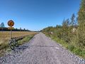
Entering the gravel road towards the hashpoint.
View to some fields in another direction.
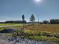
Where I had to stop cycling and continue on foot.
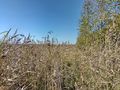
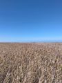
Walking through the thick and tall vegetation.
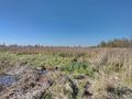
This is where I gave up and turned back. The hashpoint was somewhere there about 900 metres away.


Achievements
Kripakko earned the Done with Nature consolation prize
|