Difference between revisions of "2024-09-16 48 11"
(→Location) |
m (Location) |
||
| (6 intermediate revisions by one other user not shown) | |||
| Line 15: | Line 15: | ||
<!-- who attended: If you link to your wiki user name in this section, your expedition will be picked up by the various statistics generated for geohashing. You may use three tildes ~ as a shortcut to automatically insert the user signature of the account you are editing with. | <!-- who attended: If you link to your wiki user name in this section, your expedition will be picked up by the various statistics generated for geohashing. You may use three tildes ~ as a shortcut to automatically insert the user signature of the account you are editing with. | ||
--> | --> | ||
| + | [[User:Fenula|Fenula]] ([[User talk:Fenula|talk]]) | ||
== Plans == | == Plans == | ||
<!-- what were the original plans --> | <!-- what were the original plans --> | ||
| + | I will take the S-Bahn to Buchenhain and walk from there at around 14:00. | ||
== Expedition == | == Expedition == | ||
<!-- how it all turned out. your narrative goes here. --> | <!-- how it all turned out. your narrative goes here. --> | ||
| + | "What better way to clear my head than to take a walk in the forest?" I thought. "It will be fun" I thought. | ||
| − | + | This hash was in a pretty forest with wildlife, near a place I used to live. After attending a lecture in tax law, I was looking forward to a nostalgic and relaxing break. At first I quite enjoyed the walk, breathing fresh air and listening to raindrops pitter-patter on my umbrella. | |
| − | + | ||
| + | Until I spotted a wild boar in the bushes, just before it ran away. Excited about this encounter I continued on, only to see another (or the same?) boar disappear into the undergrowth. It didn't bother me, since boars generally aren't dangerous as long as they are not protecting piglets. | ||
| + | |||
| + | So I continued until I saw two more boars walking on the road. I approached slowly at a safe distance, expecting them to flee as well. They suddenly started walking towards me and grunting, followed by at least three more boars in the woods. It was time for a tactical retreat. The sounder followed me for a while until giving up the chase. | ||
| + | |||
| + | My first attemt at geohashing has already been thwarted by nature. At least it wasn't only the rain. | ||
== Photos == | == Photos == | ||
| Line 30: | Line 38: | ||
--> | --> | ||
<gallery perrow="5"> | <gallery perrow="5"> | ||
| + | Image:2024-09-16 road.jpg | road towards the hashpoint | ||
| + | Image:2024-09-16 boar.jpg | the bully | ||
| + | Image:2024-09-16 sounder.jpg | backup has arrived | ||
| + | Image:2024-09-16 sign.jpg | tactical retreat | ||
| + | Image:2024-09-16 train.jpg | escape | ||
</gallery> | </gallery> | ||
== Achievements == | == Achievements == | ||
{{#vardefine:ribbonwidth|100%}} | {{#vardefine:ribbonwidth|100%}} | ||
| − | + | {{done with nature | |
| + | | latitude = 48 | ||
| + | | longitude = 11 | ||
| + | | date = 2024-09-16 | ||
| + | | excuse = Blocked by boars | ||
| + | | name = [[user:Fenula|Fenula]] | ||
| + | | image = 2024-09-16 sounder.jpg | ||
| + | }} | ||
__NOTOC__ | __NOTOC__ | ||
| − | |||
| − | |||
| − | |||
| − | |||
| − | |||
| − | |||
| − | |||
| − | |||
| − | |||
| − | |||
[[Category:Expeditions]] | [[Category:Expeditions]] | ||
| − | |||
[[Category:Expeditions with photos]] | [[Category:Expeditions with photos]] | ||
| − | |||
| − | |||
| − | |||
| − | |||
| − | |||
| − | |||
| − | |||
[[Category:Coordinates not reached]] | [[Category:Coordinates not reached]] | ||
| − | |||
| − | |||
[[Category:Not reached - Mother Nature]] | [[Category:Not reached - Mother Nature]] | ||
| − | + | {{location|DE|BY|M}} | |
| − | |||
| − | |||
| − | |||
| − | |||
| − | |||
| − | |||
| − | |||
Latest revision as of 19:42, 16 September 2024
| Mon 16 Sep 2024 in 48,11: 48.0499639, 11.4767641 geohashing.info google osm bing/os kml crox |
Location
Forest in Forstenrieder Park, München
Participants
Plans
I will take the S-Bahn to Buchenhain and walk from there at around 14:00.
Expedition
"What better way to clear my head than to take a walk in the forest?" I thought. "It will be fun" I thought.
This hash was in a pretty forest with wildlife, near a place I used to live. After attending a lecture in tax law, I was looking forward to a nostalgic and relaxing break. At first I quite enjoyed the walk, breathing fresh air and listening to raindrops pitter-patter on my umbrella.
Until I spotted a wild boar in the bushes, just before it ran away. Excited about this encounter I continued on, only to see another (or the same?) boar disappear into the undergrowth. It didn't bother me, since boars generally aren't dangerous as long as they are not protecting piglets.
So I continued until I saw two more boars walking on the road. I approached slowly at a safe distance, expecting them to flee as well. They suddenly started walking towards me and grunting, followed by at least three more boars in the woods. It was time for a tactical retreat. The sounder followed me for a while until giving up the chase.
My first attemt at geohashing has already been thwarted by nature. At least it wasn't only the rain.
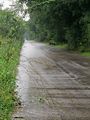
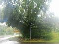
Photos
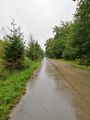
road towards the hashpoint
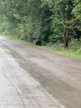
the bully
backup has arrived
tactical retreat
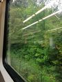
escape


Achievements
Fenula earned the Done with Nature consolation prize
|