Difference between revisions of "2024-10-13 65 25"
(Created page with "{{subst:expedition}}") |
m (Location) |
||
| (3 intermediate revisions by 2 users not shown) | |||
| Line 1: | Line 1: | ||
| − | + | {{meetup graticule|date=2024-10-13|lat=65|lon=25}} | |
| + | == Location == | ||
| + | In a forest in Isokangas nature reserve. | ||
| + | |||
| + | The point on a topographic map: [https://kripakko.neocities.org/geohash_maplink?{{#replace:{{SUBPAGENAME}}| |_}}K] | ||
| − | [[ | + | == Participants == |
| + | *[[User:Kripakko|Kripakko]] | ||
| − | + | == Expedition == | |
| − | + | I went cycling on a pretty autumn Sunday. | |
| + | This hashpoint was in a nice location, | ||
| + | and I would also be able to visit [[2024-10-14 65 25|tomorrow's hashpoint]] on the way, | ||
| + | which I would not be able to do on that day. | ||
| + | I believe the temperature was around 5 °C during the day, | ||
| + | which is quite comfortable for cycling, | ||
| + | though I would prefer 10–15 °C. | ||
| − | + | I followed the obvious road route towards the hashpoint | |
| − | + | and visited a few geocaches and the [[2024-10-14 65 25|reverse retrohash]]. | |
| − | + | I was not allowed to cycle on the trails in the nature reserve, | |
| − | + | so I had to leave the bicycle to the parking area and walk the last 900 metres or so. | |
| + | It had been raining on the previous days, | ||
| + | which had made the forest and especially the swamps damp, | ||
| + | and I could not avoid getting my shoes and feet wet. | ||
| + | Thankfully it was not any colder, | ||
| + | or my feet could have got cold, | ||
| + | but this was still manageable. | ||
| − | + | On the way back I noticed a beautiful patch of sparse forest | |
| − | + | where a lot of lichen was growing on the ground, | |
| − | + | and I took a short detour to it and took some photographs. | |
| + | I also went to the lakeshore to take pictures, | ||
| + | and there the soil was even more wet and my feet got properly soaked. Oh well. | ||
| + | When I would soon continue cycling, the muscle work would keep me warm. | ||
| − | + | To make the return home more interesting, | |
| − | + | I chose an alternative route via small forest roads and a private road. | |
| + | I was on the mountain bike today, | ||
| + | and it felt like I was not going any slower there than on the paved roads. | ||
| + | Besides, there was way less car traffic to mind and avoid, | ||
| + | and I could concentrate on enjoying the scenery | ||
| + | which, admittedly, was mostly unvaried forest. | ||
| + | I finally got back home after being out for about four hours. | ||
| − | + | According to the GPS receiver, I cycled 45.7 kilometres and walked 2.5 kilometres during the trip. | |
| − | + | I happened to cross the 65° parallel several times, which you can see in the tracklog. | |
== Tracklog == | == Tracklog == | ||
| − | < | + | <span style="color:#0000ff">Blue = cycling</span>, |
| + | <span style="color:#ff0000">red = walking</span>; | ||
| + | <span style="color:#aaaa00">yellow = the 65° parallel</span>. | ||
| + | |||
| + | I removed parts of the tracklog so I would not reveal the final locations | ||
| + | of a mystery geocache and two multicaches that I visited. | ||
| + | |||
| + | {{Tracklog|2024-10-13 65 25 tracklog.gpx}} | ||
== Photos == | == Photos == | ||
| − | < | + | <gallery perrow="14"> |
| − | Image:2024- | + | Image:2024-10-13_65_25_01-road.jpg | At the beginning of Sanginjoentie road. |
| − | -- | + | Image:2024-10-13_65_25_02-river.jpg | View to the Sanginjoki river. |
| − | + | Image:2024-10-13_65_25_03-retro_gpsr.jpg | Visiting the [[2024-10-14 65 25|reverse retrohash]]: the GPS receiver at the point. | |
| + | Image:2024-10-13_65_25_04-retro-area.jpg | Visiting the [[2024-10-14 65 25|reverse retrohash]]: the surroundings. | ||
| + | Image:2024-10-13_65_25_05-huntingsign.jpg | There may be moose hunting in this area currently... good to know. | ||
| + | Image:2024-10-13_65_25_06-info1.jpg | Information board about the nature reserve, also in English. | ||
| + | Image:2024-10-13_65_25_07-info2.jpg | Another information board about mire restoration in the area. | ||
| + | Image:2024-10-13_65_25_08-parkingarea.jpg | Where I parked the bicycle and continued on foot. | ||
| + | Image:2024-10-13_65_25_09-gpsr1.jpg | Proof of location. | ||
| + | Image:2024-10-13_65_25_10-gpsr2.jpg | Proof of date and time. | ||
| + | Image:2024-10-13_65_25_11-selfie.jpg | Stupid Grin™ | ||
| + | Image:2024-10-13_65_25_12-forest.jpg | Calm forest in the nature reserve. | ||
| + | Image:2024-10-13_65_25_13-lake.jpg | View to lake Isonkankaanjärvi. | ||
| + | Image:2024-10-13_65_25_14-colours.jpg | Trees in autumn colours in the city. | ||
</gallery> | </gallery> | ||
== Achievements == | == Achievements == | ||
| − | {{ | + | {{Land geohash | name = [[User:Kripakko|Kripakko]] | latitude = 65 | longitude = 25 | date = 2024-10-13}} |
| − | + | {{Bicycle geohash | name = [[User:Kripakko|Kripakko]] | latitude = 65 | longitude = 25 | date = 2024-10-13 | distance = 45.7 km | bothways = true}} | |
__NOTOC__ | __NOTOC__ | ||
| − | |||
| − | |||
| − | |||
| − | |||
| − | |||
| − | |||
| − | |||
| − | |||
| − | |||
| − | |||
[[Category:Expeditions]] | [[Category:Expeditions]] | ||
| − | |||
[[Category:Expeditions with photos]] | [[Category:Expeditions with photos]] | ||
| − | |||
| − | |||
| − | |||
| − | |||
[[Category:Coordinates reached]] | [[Category:Coordinates reached]] | ||
| − | + | {{location|FI|14}} | |
| − | |||
| − | |||
| − | |||
| − | |||
| − | |||
| − | |||
| − | |||
| − | |||
| − | |||
| − | |||
| − | |||
| − | |||
| − | |||
Latest revision as of 23:44, 1 November 2024
| Sun 13 Oct 2024 in 65,25: 65.0049865, 25.8765568 geohashing.info google osm bing/os kml crox |
Location
In a forest in Isokangas nature reserve.
The point on a topographic map: [1]
Participants
Expedition
I went cycling on a pretty autumn Sunday. This hashpoint was in a nice location, and I would also be able to visit tomorrow's hashpoint on the way, which I would not be able to do on that day. I believe the temperature was around 5 °C during the day, which is quite comfortable for cycling, though I would prefer 10–15 °C.
I followed the obvious road route towards the hashpoint and visited a few geocaches and the reverse retrohash. I was not allowed to cycle on the trails in the nature reserve, so I had to leave the bicycle to the parking area and walk the last 900 metres or so. It had been raining on the previous days, which had made the forest and especially the swamps damp, and I could not avoid getting my shoes and feet wet. Thankfully it was not any colder, or my feet could have got cold, but this was still manageable.
On the way back I noticed a beautiful patch of sparse forest where a lot of lichen was growing on the ground, and I took a short detour to it and took some photographs. I also went to the lakeshore to take pictures, and there the soil was even more wet and my feet got properly soaked. Oh well. When I would soon continue cycling, the muscle work would keep me warm.
To make the return home more interesting, I chose an alternative route via small forest roads and a private road. I was on the mountain bike today, and it felt like I was not going any slower there than on the paved roads. Besides, there was way less car traffic to mind and avoid, and I could concentrate on enjoying the scenery which, admittedly, was mostly unvaried forest. I finally got back home after being out for about four hours.
According to the GPS receiver, I cycled 45.7 kilometres and walked 2.5 kilometres during the trip. I happened to cross the 65° parallel several times, which you can see in the tracklog.
Tracklog
Blue = cycling, red = walking; yellow = the 65° parallel.
I removed parts of the tracklog so I would not reveal the final locations of a mystery geocache and two multicaches that I visited.
Photos
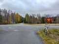
At the beginning of Sanginjoentie road.
View to the Sanginjoki river.
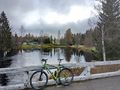
Visiting the reverse retrohash: the GPS receiver at the point.
Visiting the reverse retrohash: the surroundings.
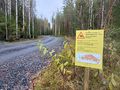
There may be moose hunting in this area currently... good to know.
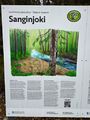
Information board about the nature reserve, also in English.
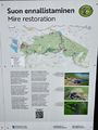
Another information board about mire restoration in the area.
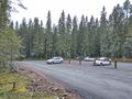
Where I parked the bicycle and continued on foot.
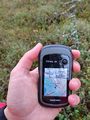
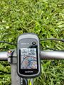
Proof of location.
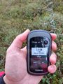
Proof of date and time.
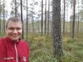
Stupid Grin™
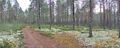
Calm forest in the nature reserve.
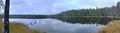
View to lake Isonkankaanjärvi.
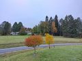
Trees in autumn colours in the city.


Achievements
Kripakko earned the Land geohash achievement
|
Kripakko earned the Bicycle geohash achievement
|