Difference between revisions of "2024-10-18 35 -97"
(rewriting this too, i was never really proud of it) |
|||
| (4 intermediate revisions by the same user not shown) | |||
| Line 1: | Line 1: | ||
{{meetup graticule|date=2024-10-18|lat=35|lon=-97}} | {{meetup graticule|date=2024-10-18|lat=35|lon=-97}} | ||
== Location == | == Location == | ||
| − | A crop field | + | A crop field just off US 81, north of Union City, OK |
== Participants == | == Participants == | ||
| Line 10: | Line 10: | ||
== Expedition == | == Expedition == | ||
| − | Oklahoma is | + | Oklahoma - not what you expect from a suburban dweller like me. My father lives here and is most proud to call this home. It was my 8th time staying over, and things were normal, really... aside from that getting out of Florida was now inevitable. The trip, therefore, was mainly for reassurance purposes, and this didn't do much because, almost at the last minute, I chose to live in California instead. Anyway, I was here for the time being. |
| − | + | Then I saw this in the morning. Union City. I've been there, mostly for the thoroughfare to Mustang. A bit far, but that's everywhere here anyway. Satellite and Street View showed it could be done; there was an opening among the fences, likely because a railroad runs through it. Any Midwestern geohasher will know this and call it blatantly obvious, but what I had figured out now: most other points are fully fenced, and every landowner is proud of their land, so often you find the signs that haunt geohashers. That and often there's no Street View coverage, so I can only assume in that case that it's not worth it. | |
| − | + | I had done quite a bit of manual labor the previous days and figured I'd have to do more this day, and I already knew the Mazda wasn't there, so I waited for my father to come home, and wanted to make the trip quick. A few minutes after the door squeaked, I exclaimed my want for exploration, and only that; I haven't told him about, and don't think he'll ever understand geohashing, not especially the "where exactly" part. He's got the landowner attribute in him, too. | |
| − | + | So off I went, turning on the new eTrex a few hundred yards in. County roads, county roads, astoundingly vertical county roads, county roads. I actually know this route just by turns. It's one of two ways we get onto OK-152, which makes a good example of state highways in the Midwest. Speed limit: 65 mph, which means people drive at least 70. Two lanes, one each direction, each barely wider than a semi, practically no shoulder most of the way. No turning lanes. Vehicle passing rules change, but no one really pays attention to them. People actually live in homes by the highway. And I was used to all of this, so I can say only small things happened. | |
| − | + | OK-152 runs to Union City (which is officially a town), then turns to Mustang just as it hits town limits<ref>Although at the time this segment of 152 was closed for maintenance.</ref>. All I had to do is keep going straight, and I was now on course to El Reno, probably a more famous name in Oklahoma. Of course, where the hashpoint sits was between the two, so I went into a left turn lane, and I was now on course to the hashpoint. | |
| − | + | And then slight panic. Approaching the crossing, lots of dust, and I couldn't see from where. ''Wait, they're doing work on it right now?'' I thought the tractors were raging at the edge of the field and therefore the trip would be for nothing. 500 feet later, though, I discovered this wasn't true. First, a pickup... then semis carrying oversized loads. I've seen many of these on interstates, but on a county road, this was the first time<ref>I have seen slightly similar, though: a few months earlier, I was taking the same route to Union City, and coming up on a very steep incline, I noticed a huge box emanating from the apex... which turned out to be a huge tractor taking up the entire road. Somehow, there was a driveway that I could pull to.</ref>. Oddly enough, a train beat the both of us, so as I came up I tried moving over to give the convoy some breathing room once they did pass. We only had to wait a minute, though; the train consisted of 4 cars, locomotive included. When I checked out the clearing, it turned out, rather than the problem I expected, to be the clearing that I cherished on Street View; no doors, no signs, just a fencepost. Inward the field was the only thing that was different: hay bales along the actual fence. | |
| − | + | So I parked near that clearing on a ditch. I now wish I hadn't; it looked like the Mazda was about to tip over. Then I phased through the clearing, followed the GPS, and there I was. And it's as hasty as it sounds. I stepped on some crops trying to find my way through, and I never bothered to take photos of the point itself, relying instead on video I took. And the haste was worsened when I got there. Oklahoma, being a thoroughly conservative and agrarian state, is a haven for arms, people who have only three emotions, and harsh punishments, so as soon as I figured I was there, I got out, fearing that the two pickups that passed were potentially landowners. That small unluck never hit, but I didn't want to run past it again, so I just took photos of the field once I was outside. | |
| − | + | Now that was done, I went home, same way. Only other thing that happened: on a county road, two kids on the side of the road, and a dad running across. The haste did, however, prove effective; trying to write about this, I was called over to the barn. | |
| − | + | "Where did you go?" "Union City. I didn't realize it was that far." And then I got to work. | |
<references /> | <references /> | ||
Latest revision as of 21:52, 8 March 2025
| Fri 18 Oct 2024 in 35,-97: 35.4350572, -97.9540501 geohashing.info google osm bing/os kml crox |
Location
A crop field just off US 81, north of Union City, OK
Participants
Plans
Kind of on impulse, really: camera, eTrex Solar, go.
Expedition
Oklahoma - not what you expect from a suburban dweller like me. My father lives here and is most proud to call this home. It was my 8th time staying over, and things were normal, really... aside from that getting out of Florida was now inevitable. The trip, therefore, was mainly for reassurance purposes, and this didn't do much because, almost at the last minute, I chose to live in California instead. Anyway, I was here for the time being.
Then I saw this in the morning. Union City. I've been there, mostly for the thoroughfare to Mustang. A bit far, but that's everywhere here anyway. Satellite and Street View showed it could be done; there was an opening among the fences, likely because a railroad runs through it. Any Midwestern geohasher will know this and call it blatantly obvious, but what I had figured out now: most other points are fully fenced, and every landowner is proud of their land, so often you find the signs that haunt geohashers. That and often there's no Street View coverage, so I can only assume in that case that it's not worth it.
I had done quite a bit of manual labor the previous days and figured I'd have to do more this day, and I already knew the Mazda wasn't there, so I waited for my father to come home, and wanted to make the trip quick. A few minutes after the door squeaked, I exclaimed my want for exploration, and only that; I haven't told him about, and don't think he'll ever understand geohashing, not especially the "where exactly" part. He's got the landowner attribute in him, too.
So off I went, turning on the new eTrex a few hundred yards in. County roads, county roads, astoundingly vertical county roads, county roads. I actually know this route just by turns. It's one of two ways we get onto OK-152, which makes a good example of state highways in the Midwest. Speed limit: 65 mph, which means people drive at least 70. Two lanes, one each direction, each barely wider than a semi, practically no shoulder most of the way. No turning lanes. Vehicle passing rules change, but no one really pays attention to them. People actually live in homes by the highway. And I was used to all of this, so I can say only small things happened.
OK-152 runs to Union City (which is officially a town), then turns to Mustang just as it hits town limits[1]. All I had to do is keep going straight, and I was now on course to El Reno, probably a more famous name in Oklahoma. Of course, where the hashpoint sits was between the two, so I went into a left turn lane, and I was now on course to the hashpoint.
And then slight panic. Approaching the crossing, lots of dust, and I couldn't see from where. Wait, they're doing work on it right now? I thought the tractors were raging at the edge of the field and therefore the trip would be for nothing. 500 feet later, though, I discovered this wasn't true. First, a pickup... then semis carrying oversized loads. I've seen many of these on interstates, but on a county road, this was the first time[2]. Oddly enough, a train beat the both of us, so as I came up I tried moving over to give the convoy some breathing room once they did pass. We only had to wait a minute, though; the train consisted of 4 cars, locomotive included. When I checked out the clearing, it turned out, rather than the problem I expected, to be the clearing that I cherished on Street View; no doors, no signs, just a fencepost. Inward the field was the only thing that was different: hay bales along the actual fence.
So I parked near that clearing on a ditch. I now wish I hadn't; it looked like the Mazda was about to tip over. Then I phased through the clearing, followed the GPS, and there I was. And it's as hasty as it sounds. I stepped on some crops trying to find my way through, and I never bothered to take photos of the point itself, relying instead on video I took. And the haste was worsened when I got there. Oklahoma, being a thoroughly conservative and agrarian state, is a haven for arms, people who have only three emotions, and harsh punishments, so as soon as I figured I was there, I got out, fearing that the two pickups that passed were potentially landowners. That small unluck never hit, but I didn't want to run past it again, so I just took photos of the field once I was outside.
Now that was done, I went home, same way. Only other thing that happened: on a county road, two kids on the side of the road, and a dad running across. The haste did, however, prove effective; trying to write about this, I was called over to the barn.
"Where did you go?" "Union City. I didn't realize it was that far." And then I got to work.
- ↑ Although at the time this segment of 152 was closed for maintenance.
- ↑ I have seen slightly similar, though: a few months earlier, I was taking the same route to Union City, and coming up on a very steep incline, I noticed a huge box emanating from the apex... which turned out to be a huge tractor taking up the entire road. Somehow, there was a driveway that I could pull to.
Photos
Passing train
Oversizes and a glance of the field
It begins, and this time I can use autofocus
Still open
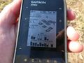
Blank map, track, and point
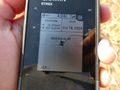
Satellite readings

Point distance (since the Solar ends routing at 10m)
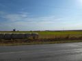
Field from afar

Aclose
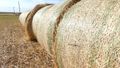
Still from video: the new hay bales

Still from video: coming rather close

Still from video: ground


Achievements
10d100h earned the Two to the N achievement
|