Difference between revisions of "2024-10-26 44 -1"
| (18 intermediate revisions by the same user not shown) | |||
| Line 7: | Line 7: | ||
[[User:Beltxarga|Beltxarga]] ([[User talk:Beltxarga|talk]]) | [[User:Beltxarga|Beltxarga]] ([[User talk:Beltxarga|talk]]) | ||
| + | |||
| + | == Plans == | ||
| + | |||
| + | On 2024-10-25 (yeah, I'm an [https://en.wikipedia.org/wiki/ISO_8601 ISO 8601] fan), I noticed that the geohash point fell within an unlocked graticule next to mine (there were still 7 of them at that time!). My first plan was to make the trip by bicycle — a 130 km round-trip almost entirely along bike lanes, and I announced it on Discord ([https://discord.gg/BvRfGat join us]!). But since I’m on holiday, I thought it’d be a great chance to bivouac there and go for the [[Camping geohash achievement]] (one of my [[User:Beltxarga#Cool_achievements_I.27d_like_to_get|target achievements]]). So, I packed up my gear and settled in for a patient wait until the next day. | ||
== Expedition == | == Expedition == | ||
| − | |||
| − | |||
Here's the tracklog. (Note that it's not an actual recording of my GPS position, but a GPX I prepared in advance to guide me, thanks to the wonderful [https://gpx.studio/ gpx.studio]. Also, for privacy reasons, it starts from Bordeaux although I don't live there.) | Here's the tracklog. (Note that it's not an actual recording of my GPS position, but a GPX I prepared in advance to guide me, thanks to the wonderful [https://gpx.studio/ gpx.studio]. Also, for privacy reasons, it starts from Bordeaux although I don't live there.) | ||
| Line 45: | Line 47: | ||
</gallery> | </gallery> | ||
| − | Back near my bike, about 200 meters from the geohash, I set up my tent in the rain and finally relaxed a bit: a change of clothes, and of course, meal prep! On the menu: buckwheat bread with butter (forgot the radishes!) and freeze-dried chicken curry. Not the most photogenic, but | + | Back near my bike, about 200 meters from the geohash and in almost pitch black (thank God for headlamps), I set up my tent in the still-pouring rain and finally relaxed a bit: a change of clothes, and of course, meal prep! On the menu: buckwheat bread with butter (forgot the radishes!) and freeze-dried chicken curry. Not the most photogenic (see below), but delicious — and definitely welcome after the afternoon’s efforts! |
| + | |||
| + | |||
| + | <gallery heights="200px" mode="packed"> | ||
| + | Image:2024-10-26_44_-1_13.jpg|Camping distance, proof #1. | ||
| + | Image:2024-10-26_44_-1_14.jpg|Camping distance, proof #2. | ||
| + | Image:2024-10-26_44_-1_15.jpg|Dinner #1: buckwheat bread with butter (forgot the radishes!). | ||
| + | Image:2024-10-26_44_-1_16.jpg|Dinner #2: freeze-dried chicken curry. Notice the [[Picnic achievement|colourful plastic tableware]] 🙃 | ||
| + | </gallery> | ||
| + | |||
| + | After a good night’s sleep (extended by an hour thanks to the switch to winter time) and a hearty breakfast, it was time to get back in the saddle for the ride home. | ||
| − | + | <gallery heights="200px" mode="packed"> | |
| + | Image:2024-10-26_44_-1_17.jpg|Breakfast #1, and proof I was there in the morning. | ||
| + | Image:2024-10-26_44_-1_18.jpg|Breakfast #2. | ||
| + | </gallery> | ||
| − | + | A great experience — and perhaps the first in a long series of “Camping geohash achievements”! 😊 | |
== Achievements == | == Achievements == | ||
| + | {{#vardefine:ribbonwidth|100%}} | ||
| + | |||
| + | {{Land geohash | latitude = 44 | longitude = -1 | date = 2024-10-26 | name = Beltxarga}} | ||
| + | {{Bicycle geohash | latitude = 44 | longitude = -1 | date = 2024-10-26 | name = Beltxarga}} | ||
| + | |||
| + | {{Camping geohash | ||
| + | | latitude = 44 | ||
| + | | longitude = -1 | ||
| + | | date = 2024-10-26 | ||
| + | | name = Beltxarga | ||
| + | | arrival = 7pm | ||
| + | | departure = 9am | ||
| + | | residence = a tent | ||
| + | | distance = 200 meters from | ||
| + | }} | ||
| + | |||
| + | {{Graticule unlocked | latitude = 44 | longitude = -1 | date = 2024-10-26 | name = Beltxarga}} | ||
| + | {{Minesweeper geohash | graticule = Bordeaux, France | ranknumber = 1 | w = true | name = Beltxarga}} | ||
| + | {{Minesweeper geohash | graticule = Arcachon, France | ranknumber = 1 | e = true | name = Beltxarga}} | ||
| + | {{Picnic | latitude = 44 | longitude = -1 | date = 2024-10-26 | name = Beltxarga | food = freeze-dried chicken curry}} | ||
| + | |||
| + | === Notes === | ||
| + | |||
| + | Although I didn't have dinner/breakfast RIGHT at the geohash, but in my tent, sheltered from the bad weather, I will still grant myself the [[Picnic achievement]]. | ||
| + | |||
| + | Theoretically, this could also have qualified for the [[Midnight Geohash]], but 1. I was 200 meters away and thus not close enough for a "Geohash"-type achievement and 2. I don't think the "second midnight" is good enough. I want the hash to "land on me". So I simply didn't bother. | ||
[[Category:Expeditions]] | [[Category:Expeditions]] | ||
Latest revision as of 20:55, 15 November 2024
| Sat 26 Oct 2024 in 44,-1: 44.8819721, -1.1690804 geohashing.info google osm bing/os kml crox |
Location
In a pine forest near Le Porge.
Participants
Plans
On 2024-10-25 (yeah, I'm an ISO 8601 fan), I noticed that the geohash point fell within an unlocked graticule next to mine (there were still 7 of them at that time!). My first plan was to make the trip by bicycle — a 130 km round-trip almost entirely along bike lanes, and I announced it on Discord (join us!). But since I’m on holiday, I thought it’d be a great chance to bivouac there and go for the Camping geohash achievement (one of my target achievements). So, I packed up my gear and settled in for a patient wait until the next day.
Expedition
Here's the tracklog. (Note that it's not an actual recording of my GPS position, but a GPX I prepared in advance to guide me, thanks to the wonderful gpx.studio. Also, for privacy reasons, it starts from Bordeaux although I don't live there.)
I departed on 2024-10-26, around 2 pm, with all my gear: tent, sleeping bag, sleeping pad, rain equipment, stove, food, etc. It's nice to be comfy!
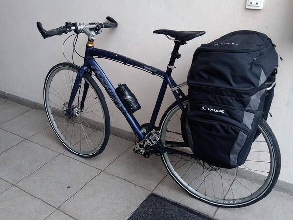
Ready to go!

The route was pleasant and mostly uneventful — almost perfect, though I would have preferred it without the rain.

Break #1.
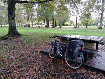
Break #2.
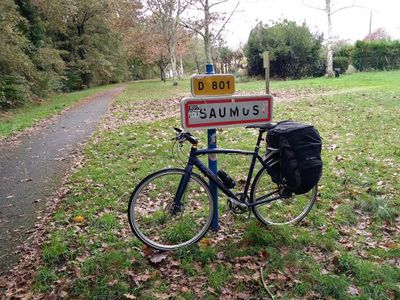
Break #3., in Saumos.
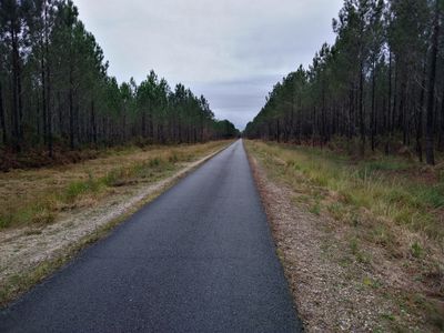
This kind of road can get boring rather quickly.
Time to pull out the rain covers.


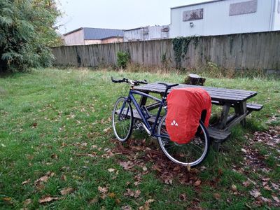
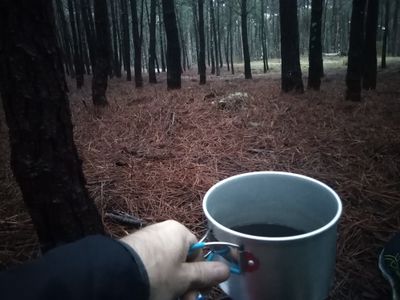
Upon arriving near the geohash, I made the mistake of dismounting to take a sandy path, which, unsurprisingly, the rain had made even less passable... After thoroughly mucking up my bike and shoes, I decided to head back to the bike path and continue until reaching the closest point to the geohash. Since this spot qualified for the "camping achievement" I left my bike there and set off on foot toward the geohash. Second setback: no signal! Geohash Droid couldn’t guide me. So, I turned back to my bike and rode nearly a kilometer to find enough reception to load the geohash in the app. Back at my future bivouac point, I left my bike again and finally ventured into the pine forest, guided by the app this time. Success!
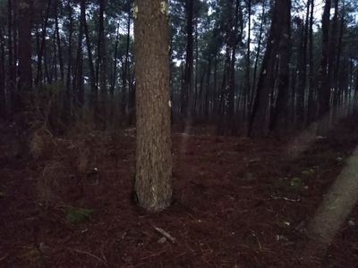
View from geohash #1.
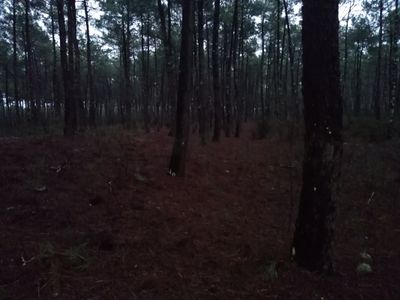
View from geohash #2.
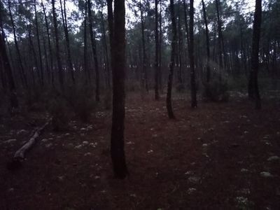
View from geohash #3.

View from geohash #4 (ARE YOU NOT ENTERTAINED?).
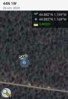
GPS proof #1.

GPS proof #2.


Back near my bike, about 200 meters from the geohash and in almost pitch black (thank God for headlamps), I set up my tent in the still-pouring rain and finally relaxed a bit: a change of clothes, and of course, meal prep! On the menu: buckwheat bread with butter (forgot the radishes!) and freeze-dried chicken curry. Not the most photogenic (see below), but delicious — and definitely welcome after the afternoon’s efforts!

Camping distance, proof #1.

Camping distance, proof #2.
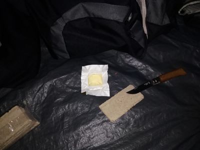
Dinner #1: buckwheat bread with butter (forgot the radishes!).

Dinner #2: freeze-dried chicken curry. Notice the colourful plastic tableware 🙃


After a good night’s sleep (extended by an hour thanks to the switch to winter time) and a hearty breakfast, it was time to get back in the saddle for the ride home.
Breakfast #1, and proof I was there in the morning.

Breakfast #2.


A great experience — and perhaps the first in a long series of “Camping geohash achievements”! 😊
Achievements
Beltxarga earned the Land geohash achievement
|
Beltxarga earned the Bicycle geohash achievement
|
Beltxarga earned the Camping geohash achievement
|
Beltxarga earned the Graticule Unlocked Achievement
|
Beltxarga achieved level 1 of the Minesweeper Geohash achievement
|
Beltxarga achieved level 1 of the Minesweeper Geohash achievement
|
Beltxarga earned the Picnic achievement
|
Notes
Although I didn't have dinner/breakfast RIGHT at the geohash, but in my tent, sheltered from the bad weather, I will still grant myself the Picnic achievement.
Theoretically, this could also have qualified for the Midnight Geohash, but 1. I was 200 meters away and thus not close enough for a "Geohash"-type achievement and 2. I don't think the "second midnight" is good enough. I want the hash to "land on me". So I simply didn't bother.
- Meetup on 2024-10-26
- Meetup in 44 -1
- Expeditions with tracklogs
- Land geohash achievement
- Bicycle geohash achievement
- Camping geohash achievement
- Graticule unlocked achievement
- Minesweeper geohash achievement
- Picnic achievement
- Expeditions
- Expeditions with photos
- Coordinates reached
- Meetup in Département de la Gironde